Weiser's Gravesite

OP
OP
Idahodutch

Idahodutch

Bronze Member
Sep 25, 2019
1,848
4,785
Idaho
Detector(s) used
Whites MXT
Gold Legend
Primary Interest:
Other
The Hidden Camp

We did not get to everything we wanted to get to. Too short of a trip.
I didn’t look for indications of Weiser’s grave.
I spent most of my time investigating the LDM.
My youngest, the workout guy, headed up to check out the shaft mine..... after several hours, he was not able to get to the spot, due to very heavy shrubbery and super thick scrub oak ... tears you up.
My other son, and my old childhood buddy, looked for one of the caches.... but it appears to have been emptied.
It’s location was a shallow impression.... about 4’ x 4’.
That cache was not buried according to info.

The hidden camp is that spot talked about.
I spent time in it. It has suffered severe damage ..... perhaps during all the activity with the tunnel audits, as a large amount of dirt/mud/rocks came down and buried about 2/3 of the two room rock house. The room I could see was about 3-1/2’ wide, and went back 4 to 5 feet, until the inflow of material, that absorbed most of the shallow cave.
The retaining wall of boulders that were used to level that area out, are still intact. Some of that grassy flat, in front of the shallow cave, have some erosion, but still mostly there.
 

OP
OP
Idahodutch

Idahodutch

Bronze Member
Sep 25, 2019
1,848
4,785
Idaho
Detector(s) used
Whites MXT
Gold Legend
Primary Interest:
Other
Dave,
Bicknell’s 1895 article is spot on!
The descriptions waltz told to Julia are accurate.

Only Weiser is still in question.
I really don’t think Waltz could have moved ALL the boulders and large rocks that were used to cover the LDM. .... by his self. :dontknow:

The rest of the article tells how to find LDM, if you know where hidden camp is.
I really don’t see anybody, being able to do any more than what we did..... which is look in awe, at the precise stacking of boulders, to replicate the shape of what the natural landscape was originally.
It would be statistically impossible for boulders to randomly stack themselves, just in that spot... on an outcropping.
... after some 140 years, that the shrubbery has still not reclaimed that area.

I checked out the outcrop, and where the brush stops, the original outcrop was taken down, ... dug down, and the rocks filled back.

That is my assessment....... done by man.

Traversing that outcropping of boulders and rocks.... a small slip of footing, where a leg slides just enough between boulders...... and broken leg time.
It’s a rough place.
 

Last edited:
OP
OP
Idahodutch

Idahodutch

Bronze Member
Sep 25, 2019
1,848
4,785
Idaho
Detector(s) used
Whites MXT
Gold Legend
Primary Interest:
Other
Bicknell’s also tells of the path, to the shaft mine.
If someone wants to find that one, it is very extreme spot.
No chainsaws ..... so lots of thick clothes, sharp hand saws, very strong legs, to stay in place on that slope, while trying to gain access.

So, again. Not much worry of it getting cleaned out anytime soon either.
Just be prepared, it is very dangerous.... the whole ravine is.

I look like I was shot in the hand and arms with a shotgun.
My clothes were not thick enough.
 

coazon de oro

Bronze Member
May 7, 2010
1,623
3,858
texas
Primary Interest:
All Treasure Hunting
Howdy Idahodutch,

Sure am happy for you, and your team. Glad that you got to check your solve, and made it out with a memory to share with all. You seem to be in better shape than I. Can't wait to see the pictures. :occasion14:

Homar
 

OP
OP
Idahodutch

Idahodutch

Bronze Member
Sep 25, 2019
1,848
4,785
Idaho
Detector(s) used
Whites MXT
Gold Legend
Primary Interest:
Other
Howdy Idahodutch,

Sure am happy for you, and your team. Glad that you got to check your solve, and made it out with a memory to share with all. You seem to be in better shape than I. Can't wait to see the pictures. :occasion14:

Homar

Homar,
Thank you for the kind words ...
I’m glad we made it in and back out.
My friend I grew up with, has bad knees. One had some work done to it a long time ago, but needs replaced according to doctors. He wore a brace on that knee while hiking, and it did ok.
His other knee popped a couple times on the way out, less than 1/2 mile from the trailhead parking lot. He is suffering as it swelled up some.

On 2nd day, is when we hiked over the east side of Boulder canyon, heading SE and entered the ravine from the West side.

By the time we hiked over that one canyon wall, We were realizing just how much we were weakened from the heavy pack hike in. We went slow.

I went across the ravine, staying at that elevation, as my youngest (mr workout) was already way ahead of me. I think I must have stopped and was just taking everything in for a bit. When I snapped out of it, I went first to the Covered outcrop and was there for a while. It is overwhelming. Anyway, then continued hiking across to the hidden camp. It was still there, but was filled in quite a bit. The spillover material, was well covered in growth. .... and mr workout, he had already made his way up into the upper left corner under the shelf.... but too much trees and brush to get all the way.
On his way coming back down a little, and then he climbed to the East a little, and back up to the top of that shelf, that overhangs that corner.

On his way, I got another container of water. All I had done, was go across the ravine once + the hike to the ravine .... and I was almost depleted physically.
I made it back over to the coveted outcrop, and spent more time investigating it, then finally made back over to a great shade spot we had noticed, when first getting to the ravine. Everybody else had been there for half an hour, by time I got there too.
I was used up, and so was everybody except for mr workout. He was able to get a pretty good look, up In that corner except for under all the brush ..... the higher up in the ravine you go ... the bigger the brush, and lots more trees. I saw a pretty good sized juniper, but it had been dead for some time.

I rested in that shade ... we all did, including my youngest, until the afternoon started to cool down. Then we hiked back to our Boulder canyon camp.

I was concerned about being strong enough to hike back out without misshapening.
We decided to get some water and filter it, and spend the next day, just recovering.
Shade, water, test, food, sleep.

I am glad we made the day for rest.
The hike out was how it should be, except for the knee thing with my friend.

So Homar .... I don’t know if we did much better than you would :)
I did see one of the pics that mr workout got ... it was taken from our Boulder camp ... about 4:45 pm, a bright light appeared on the east side of Palomino mountain.... it was Aylor’s Arch, and was easily seen. I post some pics when we get home.
We’ll see what he got ;)
 

Last edited:
OP
OP
Idahodutch

Idahodutch

Bronze Member
Sep 25, 2019
1,848
4,785
Idaho
Detector(s) used
Whites MXT
Gold Legend
Primary Interest:
Other
Homar,
After the initial hike in, after resting for the afternoon, Boulder canyon was shaded, and we hiked up to where the Military trail bends to the south.

I saw lots of rock formations ... several looked like a man ... did see a really good rock man, just to the west of our Boulder camp ..... almost directly across from the mouth of needle canyon. I’ve thought about it .... well, I don’t have a definitive answer, ... but realistically, it is all to get up to the confirmation view of 4 peaks.

I don’t know if there would be a way to prove “which” rock man, that Waltz was looking at.
Idahodutch
 

Mc4500

Full Member
Mar 7, 2013
115
101
Arizona
Homar,
After the initial hike in, after resting for the afternoon, Boulder canyon was shaded, and we hiked up to where the Military trail bends to the south.

I saw lots of rock formations ... several looked like a man ... did see a really good rock man, just to the west of our Boulder camp ..... almost directly across from the mouth of needle canyon. I’ve thought about it .... well, I don’t have a definitive answer, ... but realistically, it is all to get up to the confirmation view of 4 peaks.

I don’t know if there would be a way to prove “which” rock man, that Waltz was looking at.
Idahodutch

Any pictures of Weisers grave?
 

coazon de oro

Bronze Member
May 7, 2010
1,623
3,858
texas
Primary Interest:
All Treasure Hunting
Homar,
After the initial hike in, after resting for the afternoon, Boulder canyon was shaded, and we hiked up to where the Military trail bends to the south.

I saw lots of rock formations ... several looked like a man ... did see a really good rock man, just to the west of our Boulder camp ..... almost directly across from the mouth of needle canyon. I’ve thought about it .... well, I don’t have a definitive answer, ... but realistically, it is all to get up to the confirmation view of 4 peaks.

I don’t know if there would be a way to prove “which” rock man, that Waltz was looking at.
Idahodutch

I have thought about that, and wondered if an infrared image would show it had been worked on after more than 130 years. Waltz said he rode up to it one day, and worked on it with his pick to make it look more like a mans face. Infrared images do show if a rock has been messed with, but I have no idea if it would still show after so many years of weather. :dontknow:

Homar
 

OP
OP
Idahodutch

Idahodutch

Bronze Member
Sep 25, 2019
1,848
4,785
Idaho
Detector(s) used
Whites MXT
Gold Legend
Primary Interest:
Other
Any pictures of Weisers grave?

Mc4500,
I don’t believe so, but it was not as high on the priority list as other things.
The commodity most rare during our time in the ravine.... physical energy :icon_scratch:
Hiking in that ravine is like being in a wrestling match ... get tired, very quick :laughing7:
I think we had not fully recovered from the backpack in, the day before.
 

OP
OP
Idahodutch

Idahodutch

Bronze Member
Sep 25, 2019
1,848
4,785
Idaho
Detector(s) used
Whites MXT
Gold Legend
Primary Interest:
Other
We also didn’t go up to photograph the view of 4-peaks.
It was something I wanted to do, if had time, but was not a priority for me .... I’ve already seen it. :laughing7:

Maybe next trip, if there is time.
I still think Weiser could be buried in there.
Just going to have to start eating wheaties I guess. :)
 

dredgernaut

Hero Member
Dec 27, 2012
560
1,444
wisconsin
Detector(s) used
whites mxt, tesoro lobo super trac., monster1000
Primary Interest:
All Treasure Hunting
hi russ.. finally you got your trip.. with some success.. happy for ya.. nothing better than the first shower after getting out.. lol. way to go bud.. looking forward to seeing your pics..
 

skyhawk1251

Sr. Member
Nov 9, 2018
312
669
Kingman, AZ
Detector(s) used
Fisher Gold Bug Pro
Primary Interest:
Prospecting
Let me add my congratulations for your successful adventure. If I was in your place, I would begin a new thread, with a polished, detailed account of your trip. For starters, GE images with GPS coordinates for your camp site and main areas of exploration will give viewers an overview of your adventure. Getting photos from a cell phone to a computer can sometimes be a problem, but I'm hopeful that those photos won't be lost, and that you'll have some on-the-ground photos to describe and boast about. From what you've written thus far, I consider this to be a "recon" trip on your part. Much more could be done, with the ultimate prize being ore samples from the mine.
 

OP
OP
Idahodutch

Idahodutch

Bronze Member
Sep 25, 2019
1,848
4,785
Idaho
Detector(s) used
Whites MXT
Gold Legend
Primary Interest:
Other
Skyhawk,
Thanks for the congrats, but as you say, there are many things unfinished.

Thoughts for all of us ...
I know many or perhaps even most everyone, has a distrust of the “Waltz Map”,
and I get that.

The symbols used on the enlarged views, are a mix of landscape features, and directions.
It is important to know that the ravine location as well as the confirmation view of 4 peaks, was with me for 12 years before I really looked at the waltz map.

The hidden camp location is shown, and symbols used for the LDM outcrop on the map, are representing actual features that are seen on site. It pinpoints the center of the mine in relation to the giant pile of boulders, that now cover the end of that outcrop.
The star is representative of a sun with rays and is part of the outcrop boulder placements..
Among other things, I packed in a 2’ crow bar :laughing7: ... what a joke, .... 8’ crow bars would most likely just bend :)
Point is this, everything in that ravine, seems to be called out on that map... and accurately.
I still don’t think Waltz drew it, because it indicates Weiser being moved out of the LDM crop mine.
There is no record or tale of Waltz going back into that mine, after he buried and covered it.

I don’t know how in the world the arrangement of boulders was accomplished, but it is not nature that did it.
Climbing around on that outcrop? Is a broken leg waiting to happen. I guess the point I’m trying to get at is this:
If someone goes in and attempts to move things, they may inadvertent disrupt the secret symbols that show where things are located.
Not to mention the danger of dislodging boulders on a steep slope.

We just got back to Idaho about 11:00 today, and mr workout is still sleeping.
All of the pictures are on his phone, taken by him. He didn’t want us messing with his new phone.
I don’t think he got one of the hidden camp, or of the area around the shaft mine as he didn’t want to lose the phone.
There are a lot of trees up high in the part of the ravine under the shelf of the low ridge.
Mr workout did get to the corner in there. ...
He dropped into it from above, then had to crawl out on belly, under massively thick trees and shrubs that block entry to that corner.
In my opinion, he was within 5’ to 10’ from the shaft mine, and it lies under that wad of thick trees and brush, up in that corner.

I’m really thing about going back in November, provided we have decent monsoons.
More time, more water, get packed in, so basically fresh physically to engage the ravine.

I will share what pictures we have... give me a bit :)
 

OP
OP
Idahodutch

Idahodutch

Bronze Member
Sep 25, 2019
1,848
4,785
Idaho
Detector(s) used
Whites MXT
Gold Legend
Primary Interest:
Other
There are two caches marked on the Waltz Map, but Waltz already collected the two small caches.
We were able to locate what we believe to have been one of the small caches, but it was already gone.
We did not have time or strength to go check for the other cache.

If it is also gone, then maybe Waltz did make the map ... idk
If it is there, then Waltz didn’t make the Map.
I know, what difference does it make .... probably not much, other than more twists to stuff.

How can this go forward, so that it isn’t wrecked???
I think that Dutch Hunters, would be wise to come up with a plan for dealing with this.

We all going to see about collecting samples, and hope that each other doesn’t wreck the place, or what?
I’m open to helping however I can.

Something to think about ... how do you all want to see it unfold? Or do we finish unfolding it at all?
Maybe leave as is and shut up.... see how it plays out ?

I wouldn’t mind ending up with a chunk of nice ore, but in all honesty, it was the hunt that had me.
Now,.... I do want to wreck it.
 

OP
OP
Idahodutch

Idahodutch

Bronze Member
Sep 25, 2019
1,848
4,785
Idaho
Detector(s) used
Whites MXT
Gold Legend
Primary Interest:
Other
Here is one of the pics from our camp in boulder canyon.
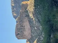
It is looking south at Palomino Mountain, and a little to the left of the big V notch at the top, is Aylors Arch lit up by the setting sun.

Just one of those cool things in there. Right now, it is lighting up about 4:45 pm until the setting sun is blocked....then the light goes out :)


Aylor's Arch from Boulder Camp.jpeg

It wasn't sideways on my computer ..... sorry but don't know how to fix.
 

Last edited:

skyhawk1251

Sr. Member
Nov 9, 2018
312
669
Kingman, AZ
Detector(s) used
Fisher Gold Bug Pro
Primary Interest:
Prospecting
I don't think you need to be concerned about sharing GPS coordinates and other information about your adventure with some trusted friends, and I can readily tell that many of the regular posters to this sub-forum can be considered "trusted friends" who would never do anything to vandalize historic sites. So, I would say that you should feel free to PM or e-mail as many of those "trusted friends" as possible. What is important is that any site of possible historic importance be thoroughly searched and documented, not just set aside to be forgotten. Only by enlisting the aid of some allies can your "site of interest" be proven or disproven. From your description of your adventure, it's obvious that only the most dedicated and motivated individuals will ever get to your "site of interest", and once they get there they won't be rolling boulders around for fun and enjoyment. Please do anything necessary to bring your search forward. Doing otherwise will just make your adventure look like just another sightseeing trip.
 

OP
OP
Idahodutch

Idahodutch

Bronze Member
Sep 25, 2019
1,848
4,785
Idaho
Detector(s) used
Whites MXT
Gold Legend
Primary Interest:
Other
Good morning/afternoon Skyhawk.
I agree, and think that documenting the site as much as possible, is a good way to preserve details of what is what, before things change.

Time changes most things, and I’m not expecting the site to stay as is, but it would be good to capture what can be captured before they change.

Lots of photos would be good.

Perhaps as you suggest, but why not a group of Dutch hunters to work together, documenting the site. A lot of actual history about the happenings in there, can come to light.

Maybe a group trek right after Rendezvous ??
I would enjoy participating in efforts like that. Just not so sure I’m the guy to head something like that up.

Skyhawk, maybe you are the guy ?? Idk
Sincerely
Idahodutch
 

skyhawk1251

Sr. Member
Nov 9, 2018
312
669
Kingman, AZ
Detector(s) used
Fisher Gold Bug Pro
Primary Interest:
Prospecting
It didn't take much Googling to discover that many people have been to Palomino Mountain/Aylor's Arch. Click on the first link below to find that its author mentions a mine dump on the slopes of Palomino Mountain. It's his opinion that the dump consists of dynamited debris. Could Aylor have been responsible for this?

https://hikearizona.com/decoder.php?ZTN=226

https://www.stavislost.com/hikes/trail/black-top-mesa-and-palomino-mountain

Some very interesting reading in the hike summary, and many photos in the second link.

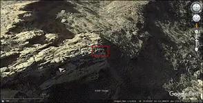
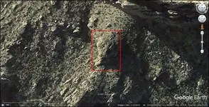
I found an arch on Palomino Mountain using GE, and a horsehead rock formation. Photos provided below with GPS coordinates at the bottom of the images.

002.png

003.png

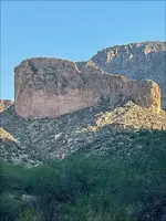
And I rotated Idahodutch's photo. Thanks Idahodutch. Hope more photos will be on the way.

C.jpg
 

Top Member Reactions

Users who are viewing this thread

Top