Re: What's this?
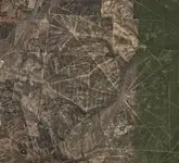
That part of the area, is flat, and also, trees were not tall enough to have a major logging operation. The area generally consisted of live oak, which soe do not grow very tall. If you look into the center of the upper web and the center of the lower web. The octagon shape in the lower right and the one in the upper left has trees around it as if it was a fort or mission wall. In the octagon one, you see square patterns that could be either a walls and outline of buildings. I don't have any explanation as the spider web design, but my unit during some time away from the unit we would tour some of the mission ruins around San Antonio, etc. I would lay money, (almost) that those squares are definitely a rock wall with trees and shrubs surrounding it. Some of the mission ruins we went to, the park quide would tell how the garden areas were walled off with only one entrance in it. Some of the gardens, etc were placed on the outside walls of the mission. Some of those smaller squares could be storeage building foundations, or also some of the missions would have different areas walled off as one would build there own fence like around thier own home property. The only thing I could figure about the spider web design could be paths cut, to show the mission from a distance from all directions so one could find it. I don't know but this is what I guess without actually going to it. Maybe it could be a fort foundations as well from the octagon outline wtih an outer wall and an inner wall surrounding the fort, mission ,etc and structure. I wouldn't mind scoping it out if you want someone to check it out with you. The Octagon one is only 3.89 miles from IH 35 and the other one is less than 2 miles.