DanielWestman
Jr. Member
What's this?
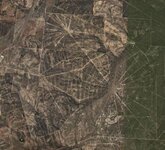
Was looking around in Google Earth when I saw this spiderweb pattern on the ground.
Anyone know what it is? Some kind of agriculture site?
Was looking around in Google Earth when I saw this spiderweb pattern on the ground.
Anyone know what it is? Some kind of agriculture site?