Why so little erosion at Treasure coast (My theory)

cache sniper 1715

Tenderfoot
Joined
Sep 4, 2007
Messages
5
Reaction score
0
Golden Thread
0
Location
Melbourne Beach
Well so far I have only seen one report of Florida wreck coins found during this wind event. Now I know that more postings would be here if things were being found out there so it got me thinking more...

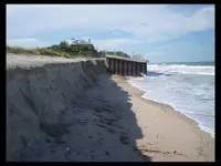
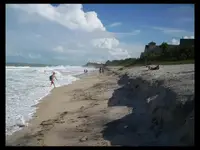
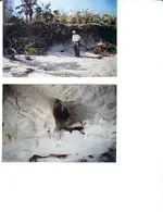
I was able to devote a good amount of time to observe the latest coastal wind event and from my observations, a cursory examination of webcams, and reports to my weather office it looks like we escaped this episode relatively unscathed from an erosion standpoint. Conventional wisdom using past events with a long duration of strong onshore component flow and large waves would argue that we should have had more erosion than what actually occurred; however, there were some subtle observed differences that may have kept the erosion minimized. The first thing that was different about this episode seems to have been the angle of incidence of wind and fetch generation area. Instead of a traditional "Nor'easter" which has winds on the order of 030-050 azimuth the winds in this case were mainly from 050-060 during the event. This small azimuthal difference lessened the effects of Eckman turning of the swell component resulting in more onshore directing of wave energy (almost perpendicular to the coast.) With coastal orientation from about 340-160 azimuth and this direct onshore focusing of wave energy I did not observe any significant waveform appearing "cuts" on the beach which one more commonly sees in the more traditional nor'easter events as wave energy focused downstream in the surf zone produces a wave like appearance to the beach. What dune erosion I did see was minor undercutting of the dune base in areas of narrower beachfronts. More disturbing than the erosion was the significant number of turtle nests that became exposed. As the turtles in most cases lay their eggs just below the base of the dune.

These are my opinions only
Comments, observations welcome

Best wishes John
 
Upvote 0
Nice observations John. You are correct that the wave energy was focused directly on shore. I talked with some surfers for a bit, and they made a similar statement about the difference of the waves. They claimed that normally in a good nor'easter, they would almost always turn south as they rode a wave along the shoreline. This time there wasn't a clear direction that was better, and most generally surfed towards the shore instead of parallel to it.

Sorry to take your scientific meteorological post and add surfer talk of "dude, these waves are bogus" to it. :D But there is some "knowledge" that can be gleened from their comments. Some stretches of beah that are angled a bit from the regular north / south coastline may have some erosion that doesn't normally exist from a standard nor'easter, no? The south shore of the cape, which is normally protected from a nor'easter, would probably have seen the same type of erosion typical of other beaches in typical nor'easters.

Thanks for the post, it put my mind to work.

Jason
 
Interesting observations. I used to keep track of the tides, winds, etc for the areas I was at years ago and thoughtg of driving to the best areas. I found this to be fun but to much over thinking a good thing. Now I just go do it when the old legs can get out to enjoy hunting.
 
I'm a newbie, all I know is shore line is getting pounded, since all reports from Treasure coast area is that there is still a lot of replenished sand down there I'm headed to beaches farther north.
 
Hey cache! According to your observations, I would be looking for a "cove" beach, and hit the middle of it down low. Don't know if there are any cove beaches in FL though.

Good info!.........HH
 
Another component that may have some bearing is that the "renourished" beaches are much coarser material than the natural sand. This coarse crap is less likely to move. It also forms steeper beaches, as it absorbs the inflow of water/waves rather than being transported.

Beach mechanics is a complex system, and all the aforementioned criteria definitely play into the results. There is no simple answer, but the major influences can be identified. In this case, wave angle is a significant factor, in my opinion.
 
Some of the beaches along the Jacksonville area that were hit by the nor'easter this week have more sand than before. I checked two sites in St. John's County this evening and there was so much sand that I was sinking near the low tide lane. The storm took 1-2 feet from the top and pushed it down over the rest of the beach.

Moe
 
Hutchinson Island's Bathtub Beach appears to be the only beach hit hard. They are trucking in sand daily in an attempt to strengthen the dunes and save some beachfront homes.
http://www.tcpalm.com/news/2007/oct/01/no-headline-02tweather/
bathtub beach sand berm 2007.webp

"Bathtub Reef Park, a popular beach hangout on Hutchinson Island in Martin County, remained one of the hardest-hit areas, with more sand being sent in for an emergency dune repair. And the rough conditions wiped out sea turtle nets across the area, created a 10-foot dropoff at Wabasso Beach Park in Indian River County and left water lapping at lifeguard stands and picnic tables in St. Lucie County."
 
I just went by bathtub an hour ago. The erosion there is a localized phenomenon, not indicitive of erosion elsewhere on the Martin County coast. Have spent the last few evenings at beaches from Brooks Beach (the Neives) south to Martin County. There has been essentially no erosion in these areas. And no, I didn't find anything significant.
 
Jupiter Inlet Park Beach - Undercut the restrooms and some sidewalk. As of 10/3
 
I went early this morning to a couple of beaches in Flagler County and there was lots of fresh sand at low tide. The storm brought a foot or more of new sand. No erosion visible. In some areas the incline is steep but again lots of fresh sand (soft). Also we have a red tide warning in this area. You can feel it in your throat (air).

Will have to wait for the next storm to take some sand away.

Moe
 
heres wabasso beach on tuesday next to the lifeguard tower looking north.next pic is looking south.last pic is a mile south of turtle trail.the only thing i found this whole stretch of beach was a ball of tin foil,a beer can and 1 1977 dime.
 

Attachments

  • wabassobeach.webp
    wabassobeach.webp
    23.5 KB · Views: 544
  • wabassosouth.webp
    wabassosouth.webp
    27.1 KB · Views: 549
  • turtletrailsouth.webp
    turtletrailsouth.webp
    43.4 KB · Views: 546
I was at John Brooks Park today....lots of sand is gone from the last time I was there 3 weeks ago, but still theres alot of sand....all I found and found plenty of was chewed up aluminum cans from the dredges.....
 
John: thanks for posting the pics. It still looks like all that has come off is the renourishment sand. We need a few more days of 25k+ winds (but later this fall please!)
 
That first pic at wabasso.there was 15 to 20 foot waves there.the wind at times during the night was over 60 mph.i know,i was on my boat since last saturday afternoon.it was fun,lots of rain,4-5 foot swells in the ICW at night.sunday an monday night we heard freight train like sounds every now an then.couldnt see the dock lights 10 feet away due to the rain comming in sideways.lots of lightning everywhere.now i really know my boat doesnt leak.the fishing sure was good the next day.water was really reddish brown from the st sebastian river.seems everytime they open the flood gates there the water gets real dirty.a few more storms like this an the new sand will go away faster then they can put new sand back.wont need a hurricane to do it.
 

Attachments

  • blackdrumblackdrum.webp
    blackdrumblackdrum.webp
    11.6 KB · Views: 525
EVERY THREE FEET of TREASURE BEACH at a depth of 2 1/2 -3 1/2 feet has treasure.

Please...don't believe me

Cappy,

I dont believe you.if treasure was there i would have found it.my MD can detect a 8 reale at a 4 1/2 foot depth.the dime i found was at 2 feet.until the fill sand comes off the beach all the way up or past the dune line.15-18 feet straight down.no one is going to find anything unless it washes up from the ocean.
 
just got home from the "treasure coast". seagrape walkover had about shoulder high cut at the dune line with black sand at the foot. i found a quarter 1985 and a few iron nails. next i went to a the beach just north of the salvor camp . 10- 12 foot cut on the beach about 20 feet from dune . i found a penny and loads of SHREDDED BEER CANS. mostly the tops and bottoms. i had to dig deep for some of them and it was not fun. about a foot and a half below the sand was a blueish clay. one more thing, at low tide i was still many feet west of the shore line i was hunting a couple months ago. mabe the next lowest tide of the month if its flat, could be good. i think we need another storm right away.
 
FISHEYE said:
EVERY THREE FEET of TREASURE BEACH at a depth of 2 1/2 -3 1/2 feet has treasure.

Please...don't believe me

Cappy,

I dont believe you.if treasure was there i would have found it...until the fill sand comes off the beach all the way up or past the dune line.15-18 feet straight down.no one is going to find anything unless it washes up from the ocean.
Fisheye is right. When a storm really cuts into the dunes, past all the renourishment, we will see more roots exposed, like in this old picture i took. The only thing washing out right now is renourishment dirt, and not enough of it. To make things worse, it appears to be laying at the low tide line and in the shallows burying anything that might be there. Hopefully coins will wash up from the ocean. A find was made, so it is possible. Thats about the only chance right now.dunes after hurricane.webp Notice how much whiter the original beach sand was before renourishment.
 

Attachments

  • dunes after hurricane.webp
    dunes after hurricane.webp
    56.2 KB · Views: 485
FISHEYE said:
EVERY THREE FEET of TREASURE BEACH at a depth of 2 1/2 -3 1/2 feet has treasure.

Please...don't believe me

Cappy,

I dont believe you.if treasure was there i would have found it.my MD can detect a 8 reale at a 4 1/2 foot depth.the dime i found was at 2 feet.until the fill sand comes off the beach all the way up or past the dune line.15-18 feet straight down.no one is going to find anything unless it washes up from the ocean.

an 8 reale at 4-1/2 feet ???
you are kidding right?
maybe you are just saying that to go along with the other comments made so far, if not...I would have made a killing this past week with it. Will you lend me it? I will split my finds with you, but I must hunt alone? Deal?
 
Trez,

Im not kidding,its for real.we did a test with my MD and a aqua pulse.we buried a 8 reale 5 feet down in the sand on the beach.the aqua pulse picked it up.my md didnt.so we moved the 8 reale up a half a foot.my MD picked it up.we even tried the reale on edge an mine and the aqua pulse picked it up.mine at 4 1/2 foot,the aqua pulse at 5 feet.my MD is a florida american electronics MAC 1 plus turbo.no longer made.if you can find one.buy it at any price you can.its well worth whatever you pay for it.i paid $600 for mine.the day after i bought it i found a zircon diamond ring.i cant remember the caret size but it was 3/8" in diameter.the ring was 24k gold.it was so big i could put it on my big toe an spin it around.a jeweler gave me $2500 for it.this was after i hit many pawn shops an other jewelry shops to get it tested.no one ever saw a zircon diamond that big.this was 8 yrs ago.i found the ring underwater 2 feet down in the sand at a well known natural spring in the swimming area.now they can make diamonds at any size.theres a factory near me that even makes the pink diamonds.not make,i guess they grow them.my dad knows the owner of the company,hes going to get me in for a tour of the factory to see how they do it.i wont ever lend out the MD.did that with the one i had before this one an never got it back.
 

Users who are viewing this thread

Back
Top Bottom