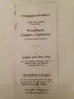
Woodbury Cabin

Oroblanco

Gold Member
Jan 21, 2005
7,838
9,830
DAKOTA TERRITORY
Detector(s) used
Tesoro Lobo Supertraq, (95%) Garrett Scorpion (5%)
roy...you have the thickest skull i ever saw...lol.....i think everyone else here understands why the guys at the pit mine are silent...why is that so hard for you to grasp?

Dave what makes you think that I do NOT "grasp" the reason(s) why the guys are silent?

They are not even "silent" about it. They let is slip in whispers around the campfire, wink-wink nudge nudge, or even speaking direct on live TV to the whole country, hint hint. If the IRS or USFS or some other entity were going to prosecute, they would have by now.


Just take that anonymous rumor to the bank! :tongue3:
 

azdave35

Silver Member
Dec 19, 2008
3,606
8,104
Dave what makes you think that I do NOT "grasp" the reason(s) why the guys are silent?

They are not even "silent" about it. They let is slip in whispers around the campfire, wink-wink nudge nudge, or even speaking direct on live TV to the whole country, hint hint. If the IRS or USFS or some other entity were going to prosecute, they would have by now.


Just take that anonymous rumor to the bank! :tongue3:
roy....i think this is turning into an obsession with you......instead of beating a dead horse on here about the pit mine..why dont you just ask the fella's that worked it and settle it for yourself once and for all
 

sgtfda

Bronze Member
Feb 5, 2004
2,351
3,887
Mesa Arizona
For you Roy

ImageUploadedByTreasureNet.com1431904735.922431.jpg
 

Oroblanco

Gold Member
Jan 21, 2005
7,838
9,830
DAKOTA TERRITORY
Detector(s) used
Tesoro Lobo Supertraq, (95%) Garrett Scorpion (5%)

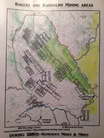
Thanks Sarge, pretty interesting. I would point out that the exact locations are not 100% accurate, as was common for claim records from the 1800s. Especially if you compare that map with the one Cactusjumper Joe posted earlier at:
http://www.treasurenet.com/forums/lost-dutchman-s-mine/200618-pinto-creek.html#post2065690

I wonder if anyone wants to take the position that the Pit mine can not be one of those claims? The mines were basically silver mines, but some nice pockets of gold were found in them. I do not buy it that any of these was ever the Lost Dutchman's gold mine. An example of the records you can pull up on this district:
Rogers District: This district is gradually developing the rich promise of a year ago. The Chloride King; The owners of this mine have contracted to sink shaft No 3, 100 feet deeper which will give the shaft a total depth of 130 feet. The contractors have accepted as a consideration for their work the ore taken out in sinking a fact showing that they consider the ore very valuable. The pay streak is 14 inches wide at the bottom of the present shaft and averages $300 per ton. It is reputed that the pay streak will widen out to 2 feet at a depth of 50 feet as a 50 foot shaft sunk on an extension of the mine shows at the bottom that width of pay streak. The World Beater is a mine of chloride and carbonate ores and has a fair 5 foot vein in the tunnel and both shafts. The work consists of one 32 foot shaft a 20 foot tunnel and a 50 foot shaft . The ore is beautiful and rich assaying frequently $1,300 per ton. The Manhattan is a continuation of the same lead to the north. There are two lodes in fact coming together on this ground It belongs to the company who own the World Beater. The Silver Chief is another mine of this company. It has a shaft of 40 feet another of 70 feet and a tunnel connecting below of 230 feet. The ore is splendid the assay value is said to be from $60 to $1,300 per ton. It is generally a carbonate and there is also galena. A drift 18 feet long which from the bottom of the shaft shows 2 feet of very rich metal is in white quartz. The Silver Chief looks better now than it has done before. The Johnny Crapeau belongs to the same company. It has abundance of magnetic iron. The ores of the World Beater Manhattan Silver Chief and Johnny Crapean are sent to the new smelter recently erected by Donahue Hutchinson & Co the bullion from which will run from $700 to $1,000 in silver per ton and 90 per cent in lead. They can work about 3 tons per day yielding about $1,500 in bullion at a cost of $40 per day. The Goodenough, the Maybell, the Snowbird, the Brown, and the Dickens are valuable locations on this ridge the latter having a shaft 85 feet deep with carbonate of lead ore running 45 per cent lead and $18 in silver. The Selma has a 15 foot shaft ore being carbonate of lead and galena and assaying $520 to $600 per ton silver. The Plato has about the same amount of work as the Selma, the ore being carbonate copper and silver and assaying $516 per ton. On the Robin mine assessment work has been done. The shaft is down 90 feet from the bottom of which they have drifted 35 feet on a pay streak 2 feet wide. There are 30 tons of ore on the dump. On the Snapp mine the owners struck 3 feet of good rock in the tunnel. The tunnel is 80 feet long and strikes the vein about 120 feet below the surface croppings. The ore is principally carbonate and has the appearance of high grade ore. The Monarch has two shafts one 100 feet and one 45 feet deep. The ore is of the same character as that found in the other mines on this lode. Assays of the ore give $400. The Sky Blue lies west of the Snapp and has created much interest on account of its highly colored blue ores.

It is proposed to work the mines of this neighborhood which are near river by pumping water by steam to the ground.
from Report of the Director of the Mint Upon the Production of the Precious Metals, 1883, pp 92-93

I notice there are several named claims and mines mentioned in late 1870s like the Monarch, which are not shown on the map as well, but perhaps they were dropped or re-located and claimed under different names.


Oroblanco
 

cactusjumper

Gold Member
Dec 10, 2005
7,754
5,388
Arizona
In case anyone missed it, or did not understand what was being shown with the actual claim document and the map, I will explain it.

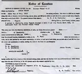
The claim states that the Silver Chief is 3-miles in a N. Westerly direction from Rodgers Trough, and that it endlines with the Silver Chief Claim. The map shows the location of what is being called the Silver Chief and the area where it should be.

Joe Ribaudo
 

Last edited:

sgtfda

Bronze Member
Feb 5, 2004
2,351
3,887
Mesa Arizona
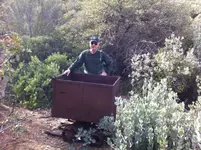
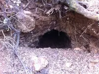
The names on some of the mines changed over the years. Example Sky Blue was a Silver Chief #2,3 or 4. I don't recall. Now nicknamed the Ore Cart mine
ImageUploadedByTreasureNet.com1431956192.147090.jpg ImageUploadedByTreasureNet.com1431956215.349713.jpg
 

OP
OP
Old

Old

Hero Member
Feb 25, 2015
656
1,409
Virginia
Detector(s) used
Whites
Primary Interest:
All Treasure Hunting
Thank you Frank for posting this map. Its a great resource. Puts a lot of perspective into the picture.

I'm a little confused on the scale. Is it just me or does the scale of the locations of the mines seem off in relation to the distance between Roger's Trough and Reavis Creek. Am I correct that the distance between the creeks is roughly 1.25 miles???

I'm mindful it says the mine locations are not accurate. I'm just trying to adjust them as best I can. Seems to me they need to be adjusted down in size about 30%. Sound right?

I could be confused, heck! I have a hard time finding my way home sometimes. If I'm anyway close to right, which description carries more weight? The mine claim or the map?

If its the mine claim, Joe is absolutely right that 3 miles n/w of Roger's Trough moves the whole thing significantly.
 

Last edited:

azdave35

Silver Member
Dec 19, 2008
3,606
8,104
Thank you Frank for posting this map. Its a great resource. Puts a lot of perspective into the picture.

I'm a little confused on the scale. Is it just me or does the scale of the locations of the mines seem off in relation to the distance between Roger's Trough and Reavis Creek. Am I correct that the distance between the creeks is roughly 1.25 miles???

I'm mindful it says the mine locations are not accurate. I'm just trying to adjust them as best I can. Seems to me they need to be adjusted down in size about 30%. Sound right?

I could be confused, heck! I have a hard time finding my way home sometimes. If I'm anyway close to right, which description carries more weight? The mine claim or the map?

If its the mine claim, Joe is absolutely right that 3 miles n/w of Roger's Trough moves the whole thing significantly.

if you are calling the creek with reavis grave reavis creek then yes..its about 1.25 mile from rogers trough...modern mining claims are 1500 foot long but back then they might be different...if it was a heavily claimed area then the claims could be smaller.. and the claims on the map frank posted are hand drawn so they aren't to scale....and like frank says alot of times the claim name changes when it changes owners...another thing to remember....if you stake a claim now you have to include a pretty accurate map of your claim location...but in 1880 all you had to do was give a general direction and distance from a known location..example...3 miles n.w. of rogers trough....back then they didnt have accurate maps so what the claimant thought was 3 miles may be 2 miles...i've tried to locate 100 year old claims on the ground using the description on claim papers and it can be tough....and trying to decipher the handwriting on these old claim notices are hard also as they were written out in cursive and not typed
 

Oroblanco

Gold Member
Jan 21, 2005
7,838
9,830
DAKOTA TERRITORY
Detector(s) used
Tesoro Lobo Supertraq, (95%) Garrett Scorpion (5%)
They were operating under the 1872 Mining Act, so lode claims were the same as now 1500 feet long. As was stated, the location descriptions were just written as the ESTIMATE of the person filling out the claim form, not like a land survey. It has long been the policy in court that the monuments on the ground hold precedence over all written descriptions.

It was also not uncommon for miners to write the wrong location info on their claim documents, deliberately, to mislead possible claim jumpers, knowing that the monuments on the ground are what count if the matter is ever brought to court.

Oroblanco
 

sdcfia

Silver Member
Sep 28, 2014
3,657
8,879
Primary Interest:
Other
Much of the civil law infrastructure in the western states developed originally to mediate mining claim disputes in the remote camps. While it was required to post corners on a lode claim @600'x1500', a lot of multiple overstakings occurred, often at all sorts of crazy quilt angles. The courts decided who was first and who had rights to what ground. Frequently a valid mining claim ended up being a "nuisance fraction" of only a couple hundred square feet or less - the leftover piece of open ground surrounded by claims adjudicated by the court. Some of these fractional claims became extremely valuable whenever they were in the middle of a large group of other producing claims - they had to be purchased to consolidate the larger group's holdings. The Virginia City, NV mining history is full of these types of claim fights.
 

OP
OP
Old

Old

Hero Member
Feb 25, 2015
656
1,409
Virginia
Detector(s) used
Whites
Primary Interest:
All Treasure Hunting
I wonder if anyone wants to take the position that the Pit mine can not be one of those claims? The mines were basically silver mines, but some nice pockets of gold were found in them. I do not buy it that any of these was ever the Lost Dutchman's gold mine.

Oroblanco

Actually, I do take the position that the Pit mine MAY not be one of those claims.

At least it may not be one of the places actually worked on those claims.

Assuming, (yet to be 100% confirmed) that a team of miners worked for 3 summers in the mid 1990's and removed much valuable material using much the same methods as the 1880 miners, I would say that the folks that worked these claims in the latter part of the 1880's were not "on to" the fruits of the Pit Mine. Are we to assume that the 1880 miners were on the very spot and missed it?
 

Oroblanco

Gold Member
Jan 21, 2005
7,838
9,830
DAKOTA TERRITORY
Detector(s) used
Tesoro Lobo Supertraq, (95%) Garrett Scorpion (5%)
Actually, I do take the position that the Pit mine MAY not be one of those claims.

At least it may not be one of the places actually worked on those claims.

Assuming, (yet to be 100% confirmed) that a team of miners worked for 3 summers in the mid 1990's and removed much valuable material using much the same methods as the 1880 miners, I would say that the folks that worked these claims in the latter part of the 1880's were not "on to" the fruits of the Pit Mine. Are we to assume that the 1880 miners were on the very spot and missed it?

I would not assume that 1880's miners would leave rich ore visible, yet sometimes they did. Some old mines which were considered "played out" in the 1800s have been re-opened in our time, and by the use of metal detectors have produced millions of dollars in gold, like the now famous 16 to 1 mine in California. The problem was that if they could not see the gold or silver in 1880, they would only find it by chance. So good pockets could get missed very easily. This is one of the reasons why some of us are so interested in some old mines that were considered all worked out.

Another possibility is that the mining simply stopped when a load of ore was prepped to go. This would fit the Peralta/Ludy story very well, but will also work for the 1880s miners whom did not own their own mill for crushing and processing the ore, it would have to be packed and freighted out to a mill. There would be little sense in mining out more rich ore than you could carry in a trip to the mill, unless you had someone whom could stand guard over it. Otherwise it was just as safe out of sight, still in the mine. Most robbers would prefer to grab gold already mined out, than to have to crack the rock themselves to get it out. Also, some rather unscrupulous mine owners would deliberately leave rich pockets showing in plain sight, so that to sell the mine (which may have very little other ore of value remaining) they could show the potential buyer the nice silver or gold showing, and get a top price for a mine that you could extract all the remaining values in a short time.

Which claim or claims did the Woodbury's have? It may have been posted but if I saw it I forgot and now don't see it. Thank you in advance (to anyone with the answer)

Oroblanco

:coffee2: :coffee: :coffee2:
 

OP
OP
Old

Old

Hero Member
Feb 25, 2015
656
1,409
Virginia
Detector(s) used
Whites
Primary Interest:
All Treasure Hunting
I'm reposting the claim location file below, previously shown by Joe, (I think). I haven't had an opportunity to confirm that the Woodbury's filed on all the "Silver Chief" claims but that's my working theory. Could be wrong.

SILVERCHIEFCLAIM-1.jpg
 

OP
OP
Old

Old

Hero Member
Feb 25, 2015
656
1,409
Virginia
Detector(s) used
Whites
Primary Interest:
All Treasure Hunting
Now, <g> If (big if) the gold ore that has been shown around, some of which has been posted on this site and other sites, which I think all would agree is RICH stuff, came from the Pit Mine. And, it has been bantered about that the Pit mine, and the Silver Chief #2 are the same mine. It would not be too likely that the Woodbury's would have left it un-harvested.

This gets deeper and deeper if, as some of the people involved have reportedly said, this is ALSO the true LDM. There are an awful lot of unanswered questions here.

Either:
the Silver Chief is not the same as the Pit Mine.
The pictures we have seen are not from either mine
or; the Woodbury's were the worst prospectors in the history of Arizona

Also, if the Pit mine and the Silver Chief are the same mine, where's the scraps from the silver extraction?
There many be more questions, but this is just a start.

This would make a lot more sense if I could post the pictures from the Pit mine location, the "supposed" recent dig site <cough, cough> and the Ted Cox photos of the shift from the 1950's. I don't have permission for that but they are out there to see. Just takes a while to collect them all up.
 

cactusjumper

Gold Member
Dec 10, 2005
7,754
5,388
Arizona
Lynda,

I have noticed that Greg Davis has looked in on this subject. I can't imagine that he does not have a ton of information on the Woodbury's. You should try to get him to give some of it up. Perhaps a specific question addressed directly to him.

Good luck,

Joe
 

OP
OP
Old

Old

Hero Member
Feb 25, 2015
656
1,409
Virginia
Detector(s) used
Whites
Primary Interest:
All Treasure Hunting
I have just written to Mr. Davis. I hope he responds but if he doesn't its certainly understandable. He doesn't know me from Adam. Doesn't know if I'm friend or foe. And; is probably fed up with folks mooching on his research.

I'm interested in this purely for the hunt. Wish that I could actually do some on site looking but; alas, that's not to be. About all I can handle, and that's not at cake walk, is to pan a somewhat local creek from time to time. No way I'm a threat to anyone that's a genuine Dutch Hunter.
 

cactusjumper

Gold Member
Dec 10, 2005
7,754
5,388
Arizona
I have just written to Mr. Davis. I hope he responds but if he doesn't its certainly understandable. He doesn't know me from Adam. Doesn't know if I'm friend or foe. And; is probably fed up with folks mooching on his research.

I'm interested in this purely for the hunt. Wish that I could actually do some on site looking but; alas, that's not to be. About all I can handle, and that's not at cake walk, is to pan a somewhat local creek from time to time. No way I'm a threat to anyone that's a genuine Dutch Hunter.

Lynda,

Greg is very generous with his time and his collection......which is massive. If for some reason he can't get back to you, I would suggest you make it a point to come to the next Rendezvous. Greg has not missed one of them. Beyond that, there are many, many very knowledgeable Dutch hunters who will be pleased to speak to you.:lurk:

Good luck,

Joe
 

Top Member Reactions

Users who are viewing this thread

Top