- #1
Thread Owner
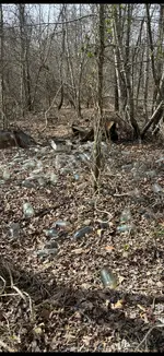
I know rightBe careful and make sure it's not an old well.
I'm going to check it out todayI’m be on that like stink on shyte
It looks like the bottles are all intact. I'd have to paw through there and see how deep and how old it got.It's a trash pit/ bottle dump, that's a lot of surface bottles, I can't imagine how many layers there are
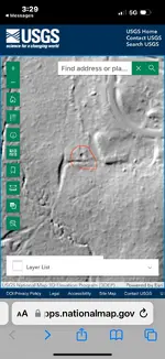
I'm with you there. I can't figure out how to get to lidar. Nathan can you run us through the sidebar menu steps to get to lidar imagery?I’m amazed to see lidar on a USGS site. I hope they have lidar for my area. And I can figure out how to navigate the site.
I will try tomorrowI'm with you there. I can't figure out how to get to lidar. Nathan can you run us through the sidebar menu steps to get to lidar imagery?
Try this for now it should take you right to ithttps://apps.nationalmap.gov/3depdem/I'm with you there. I can't figure out how to get to lidar. Nathan can you run us through the sidebar menu steps to get to lidar imagery?
Thanks. I can't get finer than 1 meter. And it seems my connection is no where near fast enough to get data as would be non irritatingTry this for now it should take you right to ithttps://apps.nationalmap.gov/3depdem/

I have couple spots around here like that. People in the 40s or 50s didn’t want to go to the dump (maybe there wasn’t one) and found a spot in the woods to dump trash. Unfortunately for me, one of those spots is on top of a csa calvary camp. Unfortunate to dig 99 zinc lids/bottle tops per each bullet.It's a trash pit/ bottle dump, that's a lot of surface bottles, I can't imagine how many layers there are