Yankee Jims Road California

infotraker

Full Member
Joined
Dec 20, 2013
Messages
193
Reaction score
282
Golden Thread
0
Location
Ca
Detector(s) used
Whites mxt
Primary Interest:
Prospecting
Does anyone know the condition of Yankee jims road going down to the n. Fork American river ? I heard that the road was in bad shape after all of the rain. Is it drivable from both sides ? Thanks for any info.
 
Upvote 0
only foresthill side open as far as i know. becareful stay out of sight. im told asra is hating on prospectors right now and discouraging people.. when did the Asra turn soley law enforcent? fortunate for us they know very little about the lands they govern and rarely go past a fee box.
 
Thanks for the info.
 
I spoke with an ASRA rep at Mineral Bar about a month ago. She said that they have a guy on a motorcycle that rides across the landslide areas and checks down there and also Ponderosa. The website I checked today said both roads were closed with Ponderosa closed on both sides due to erosion.
 
Colfax side is open, friend drove down yesterday. No large trucks advised. Still checking with park people to see if forest hill side drivable. May go weds.
 
Good to hear infotracker. Thanks for the update. Now if they can just remove the 1'-2' of sterile sand that coated the area in December.....
 
Both sides open, colfax side has some ruts and one 2 ft high dirt PILE IN THE ROAD BUT YOU CAN GET OVER IT SLOWLY. Forest hill side graded where land slides, easy to go thru. Road signs on forest hill side say road closed but is open.
 
I'm not sure how it works in USA but in AUS if there is a road closed sign and you pass it, then damage your vehicle, 99% of the time your insurance company will laugh at you if you claim..

Sent from my GT-I9305 using Tapatalk
 
I'm not sure how it works in USA but in AUS if there is a road closed sign and you pass it, then damage your vehicle, 99% of the time your insurance company will laugh at you if you claim..

Sent from my GT-I9305 using Tapatalk

I'm guessing most of the guys here are like me & only have liability insurance om their mining rigs so we are out of luck anyway!
 
The road is a single lane dirt road most of the way is perched on the side of a steep mountain above a creek. There was much erosion and damage with the big storms along the road and the main washout was an area where the mountain let go a section about 100' high and 50' wide which sent most of the road in that place down into the canyon. The road is dangerous during every rain event and afterwards there are always piles and pieces of jagged rock laying in the road. Your vehicle could easiy get bonked by a thousand pounder or washed over the edge with a slide if you are the unlucky type. Its drying up now and unless we get another heavy storm only small rocks to contend with pelting the road. Stay Safe.
 
and the county can't wait for it to get to the point of total closure
 
The country really worked on the forest hill side, lots of slides but road is back better than before the winter. They put down gravel in many places.
 
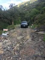
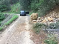
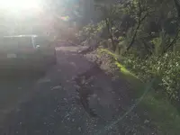
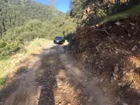
Yankee jims road on its best day is a doosie. I went down the road today and it was rough to say the least. Washouts and landslides made me contemplate turning around a couple of times. I made it and thought about taking the foresthill side home after prospecting but said screw it and went through the gauntlet one more time to get outta there. It was a beautiful day and i got a little bit of gold to add to the pile. ImageUploadedByTreasureNet.com1491093504.910224.webpImageUploadedByTreasureNet.com1491093529.642425.webpImageUploadedByTreasureNet.com1491093558.516916.webpImageUploadedByTreasureNet.com1491093578.483273.webp
The pictures dont do the slope of the mountain justice...if you go off the road, almost certain death. I wouldnt go down that road unless you are experienced and have 4 wheel drive. Oh and watch for ticks, i got 2 today!!
 
Haha, here in the Colorado mountains we'd call that a highway!
 
Haha, here in the Colorado mountains we'd call that a highway!
Same here K in C ... that looks smoother than some of the highways in my neck of the woods.

Sent from my GT-I9305 using Tapatalk
 
I like the look of that country, and I'm with a couple of the other guys in thinking that your road looks mighty passable compared to some of the sketchy trails I drive to get to the gold.

Thanks for the pictures as it's always fun to get a look at new country. All the best,

Lanny
 
No4x needed on this road. It is very passable in dry weather. It just slides out in wet weather and has lots of falling rock. In dry weather it gets so much use that the main problem is collision with someone overdriving the road. Those are the two things that makes it sketchy. Last year on a wet day someone lost their car into the creek. It was their last drive.
 
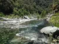
Lanny. Here are a couple of pics for you of the river that this road takes you to. One is above the bridge and one is below the bridge.


IMG_3290.webpIMG_2637.webp
 
Wow. That road looks in much worse shape than I remember it from the early 90s. Good times prospecting and hiking down there back then.


Sent from my iPhone using Tapatalk
 
Has anyone been able to cross shirttail creek at Yankee jims bridge currently ?
 

Users who are viewing this thread

Back
Top Bottom