markmar
Silver Member
- Oct 17, 2012
- 4,120
- 6,263
- Primary Interest:
- All Treasure Hunting
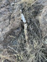
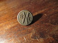
Guano?View attachment 2108840
What do you think they mined here, on Malapai?
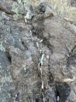
Guano?View attachment 2108840
What do you think they mined here, on Malapai?
Excellent info, thank you. One of the few books I have not read, and it’s leaving me
ill informed. I wouldn’t agree that statement told to Reid proves the 1st set of covered mines occurred on black top Mesa, however.
I do recall reading somewhere that Geronimo Head was also called a black mountain or some other name with black in it. It is also north of the needle, with quite a few interesting options for other covered mines up canyon. From black top mesa, up canyon could only be weavers needle or bluff springs?
It has always felt that a lot of searchers want/wanted the location to be on black top mesa. I do understand there is a wealth of information out there that I won’t ever see or hear. From the limited info I do have to work with, i personally don’t understand the fascination.
Mr. Roberts, would you be willing to draw out privately or publicly the trail long forgotten that heads up malapai you mentioned?Geronimo Head mountain was in the early days known as Lewis Mountain.
It was Malapai that was once known as black mountain.
The Black mountain we know today was formerly known as Charleboise (Charley Boy) mountain.
All these names were changed, moved, switched and added when the official topo maps were updated in the late 50,s early 60's.
Al Reser took over Roy Bradford's camp in upper Deering canyon at the southeast base of Malapai Mountain in about 1960.
There are a few mine diggings in that southeast base of Malapai not far from Reser's camp.
Al showed me those diggings and a trail long forgotten that led up to the top of Malapai that no one would believe possible.
") .
. I have seen those diggings and they dont go very deep but they sure do make you wonder what they were looking for..of course ..that is not an easy place to get to . .and the steep loose gravel is no picnik.....lol..ive been all over that area and there is definatley alot to take in.Geronimo Head mountain was in the early days known as Lewis Mountain.
It was Malapai that was once known as black mountain.
The Black mountain we know today was formerly known as Charleboise (Charley Boy) mountain.
All these names were changed, moved, switched and added when the official topo maps were updated in the late 50,s early 60's.
Al Reser took over Roy Bradford's camp in upper Deering canyon at the southeast base of Malapai Mountain in about 1960.
There are a few mine diggings in that southeast base of Malapai not far from Reser's camp.
Al showed me those diggings and a trail long forgotten that led up to the top of Malapai that no one would believe possible.
Where are they exactly? I would love to visit them on my next trip out there.I have seen those diggings and they dont go very deep but they sure do make you wonder what they were looking for..of course ..that is not an easy place to get to . .and the steep loose gravel is no picnik.....lol..ive been all over that area and there is definatley alot to take in.
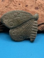
Continuing with the topic of cool things to see…!
Manmade? Great idea if it was, and I’m fairly sure it was! On the hike up to the top of Geronimo head.
Very cool to have it line up with the 4 peaks.
View attachment 2112910
Thanks for sharing your pictures. I miss being out there.
Is the road beyond Tortilla Flat (or Mesquite Flat) still closed? Or has it opened again?
Deducer - as of a couple weeks ago 88 is gated starting just at the top of Fish Creek Hill - right by the entrance to the overlook parking area.Thanks for sharing your pictures. I miss being out there.
Is the road beyond Tortilla Flat (or Mesquite Flat) still closed? Or has it opened again?
Easy to see why, it’s really great country. Felt like home once we got up a bit higher out of the canyons! View attachment 2117649
We took 88 past TF, to the TF trailhead. Signs stated the road was closed ahead but didn’t get far enough to see where it was closed.
TF Trailhead is still open. Nope - not meWas the TF trailhead open?
Also, is that you sitting on the rock?
Yes, the trailhead parking was open, road past it to the ranch was in bad shape, but i understand it has been for awhile.Was the TF trailhead open?
Also, is that you sitting on the rock?
Yeah - the first section of road to the old ranch site is rough - I think the Forest Service likes it that way to be honest - cuts down on the number of people who can drive it.Yes, the trailhead parking was open, road past it to the ranch was in bad shape, but i understand it has been for awhile.
That's a friend on the rock, im in the blue below! View attachment 2117804
I drove FR213 from the Apache Trail to the Tortilla Windmill yesterday for my hike up to Tortilla Peak area, my Jeep Rubicon had no trouble.Yeah - the first section of road to the old ranch site is rough - I think the Forest Service likes it that way to be honest - cuts down on the number of people who can drive it.