Jolly Mon
Hero Member
- Joined
- Sep 3, 2012
- Messages
- 868
- Reaction score
- 631
- Golden Thread
- 0
- Primary Interest:
- All Treasure Hunting
- #1
Thread Owner
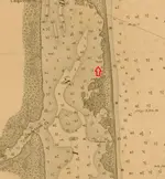
Indian River chart circa 1878 shows "snag" almost directly behind Bonsteel Park
 Click to enlarge.
Of course it could be anything.
This is a fraction of a chart which shows many miles of the Indian River Lagoon system circa 1878.
The only "snag" I could find on the entire chart was this one.
What a coincidence it would be almost directly behind Half-Reale Beach.
 Click to enlarge.
Of course it could be anything.
This is a fraction of a chart which shows many miles of the Indian River Lagoon system circa 1878.
The only "snag" I could find on the entire chart was this one.
What a coincidence it would be almost directly behind Half-Reale Beach.


