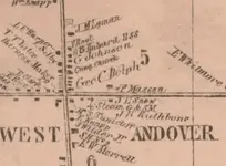
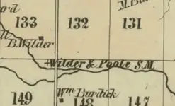
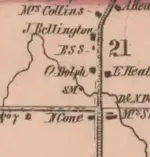
1856 Map... What does SM mean?

Noah_D

Bronze Member
Joined
Dec 14, 2017
Messages
1,593
Reaction score
3,492
Golden Thread
0
Location
Illinois (prev. NE Ohio)
🏆 Honorable Mentions:
1
Detector(s) used
Nokta Makro Simplex+, Garrett ACE 300, Carrot
Primary Interest:
Metal Detecting
Howdy!

I have been perusing this map of ashtabula county from 1856 a lot recently and I can't help but notice something like this "+ SM" in some locations, often by a creek but not always. I have no idea what this means but I am sure someone else does, If you have any idea please respond! I took a few screenshots just now that I will attach.
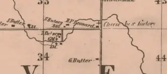
Screen Shot 2019-12-26 at 7.11.15 PM.webpScreen Shot 2019-12-26 at 7.11.26 PM.webpScreen Shot 2019-12-26 at 7.11.48 PM.webpScreen Shot 2019-12-26 at 7.17.22 PM.webp

The "+" symbol is usually next the SM, but sometimes also GM or in one of the screenshots "Cheese box factory"

My thoughts is maybe sawmill and gristmill for the SM and GM, but the problem with that would be that I know some of these creeks barely flow at all.

Thank you for reading!
 

Last edited:
Sorry about the pictures they loaded funny.
 

Thanks U.B.! I appreciate the link... I wonder how much water a sawmill needed back in the day, cause some of these creeks are pretty small. Another topic to research for another day I guess.

yes,I just downloaded a 97 page pdf on map abbreviations...
 

I agree that SM is for saw mill and GM is for grist mill. I have seen this before on old maps of my town & county here in VT
 

Thanks for the confirmation Colonial Digger! Out of curiousity, have you ever gotten a chance to detect one of the old mills like on the map?
 

Some of our smaller creeks down here appear not to have the flow amounts as they once had. I assume it's because of growth in agriculture and water use for crops.
 

Last edited:
Interesting. I am working on getting permission for a site that had one of these old mills right now. I'll see what I can find if I can get my coil over one of these sites.
 

Thanks for the confirmation Colonial Digger! Out of curiousity, have you ever gotten a chance to detect one of the old mills like on the map?

I searched in the river this summer near where I thought some old mills once were but I didn't find much at all. I actually think I was searching in the wrong spot and the mills may have been further down stream.
 

I doubt the "S. M." refers to sawmill. Buildings and structures are usually indicated by a filled in square. Commonly in mapping the plus sign "+" indicates a physical location monument - not a building. I would expect that +SM is actually the location of a surveyors monument. Cartographers include survey monuments to lend credence and accuracy to their mapping.
 

I doubt the "S. M." refers to sawmill. Buildings and structures are usually indicated by a filled in square. Commonly in mapping the plus sign "+" indicates a physical location monument - not a building. I would expect that +SM is actually the location of a surveyors monument. Cartographers include survey monuments to lend credence and accuracy to their mapping.

Thats very interesting, I am reading about surveyors marks and things right now. I do still have a few reservations though, I am still wondering why it would always be by rivers or creeks. And in the townships and settlements that were known to have mills often had these marks, and usually right by the river. Also what would +GM and +Steam SM mean?

I appreciate the comment, its definitely worth looking into. I don't know enough about it yet though to be sure about anything.

Thanks! Noah
 

One screen shot says "Steam G. & SM"
so, steam-driven grist mill and saw mill - both very important in early days...!
 

One screen shot says "Steam G. & SM"
so, steam-driven grist mill and saw mill - both very important in early days...!

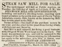
Steam is a remote possibility. I can find no historical reference to a steam powered mill in Ashtabula County but that doesn't mean it didn't happen.

More to the point is that the earliest known steam powered mill in Ohio was at the Algonquin mill. That steam engine was installed in 1890. The Issac Ludwig mill installed steam power in 1908.

The 1856 date on the OP's map is a very early date for steam powered mills anywhere in the territories. Steam power didn't become common in the United States until after the Civil war. I think if there had been a steam powered mill anywhere in Ohio during that period it would be well documented.
 

Thanks U.B.! I appreciate the link... I wonder how much water a sawmill needed back in the day, cause some of these creeks are pretty small. Another topic to research for another day I guess.

yes,I just downloaded a 97 page pdf on map abbreviations...

Can you please post a link?
 

Steam is a remote possibility. I can find no historical reference to a steam powered mill in Ashtabula County but that doesn't mean it didn't happen.

More to the point is that the earliest known steam powered mill in Ohio was at the Algonquin mill. That steam engine was installed in 1890. The Issac Ludwig mill installed steam power in 1908.

The 1856 date on the OP's map is a very early date for steam powered mills anywhere in the territories. Steam power didn't become common in the United States until after the Civil war. I think if there had been a steam powered mill anywhere in Ohio during that period it would be well documented.

https://resources.ohiohistory.org/ohj/search/display.php?page=5&ipp=20&searchterm=shakers&vol=84&pages=5-56

http://leehite.org/documents/Made%20In%20Ohio%20%20Steam%20Powered%20Machinery.pdf

Take a look..some interesting history there.

My vote is for Sawmill and Gristmill.
Very important at the time to be shown on a map.
 

Steam is a remote possibility. I can find no historical reference to a steam powered mill in Ashtabula County but that doesn't mean it didn't happen.

More to the point is that the earliest known steam powered mill in Ohio was at the Algonquin mill. That steam engine was installed in 1890. The Issac Ludwig mill installed steam power in 1908.

The 1856 date on the OP's map is a very early date for steam powered mills anywhere in the territories. Steam power didn't become common in the United States until after the Civil war. I think if there had been a steam powered mill anywhere in Ohio during that period it would be well documented.
I just came across an interesting ad for a Steam Saw Mill in the Ashtabula Sentinal from 1859 and it reminded me of this thread...Screen Shot 2020-10-24 at 11.07.53 AM.webp
 

Verify by looking up "Old Mill Road" in the same areas on todays maps!
 

Verify by looking up "Old Mill Road" in the same areas on todays maps!
That's definitely a good idea! I don't think a lot of people realize the history contained in things as simple as road names.
 

I ran across an old survey plat that called out “cabin Gulch”...just a small non descript drainage.
Guess what I was doing the next weekend?

Didn’t take long to find the old chimney.
 

Top Member Reactions

Users who are viewing this thread

Latest Discussions

Back
Top Bottom