A "Rock Cabin" and an Old Mine

somehiker

Silver Member
May 1, 2007
4,365
6,426
Primary Interest:
All Treasure Hunting
Seems you have found the correct one. Remains to find the other gold mines in the region.

PS

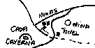
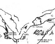
I didn't know the CASA ( house ) is similar to a cliff face.

Does this help ?.....

DSCF1354  Casa caverna 2.jpg
 

somehiker

Silver Member
May 1, 2007
4,365
6,426
Primary Interest:
All Treasure Hunting
A couple of GE views.....
The second shows the GE distance in ft. from the cavern to what I suspect may be a covered pit fitting Waltz's description(s) > Julia and Rhiney .

CC GE.jpg

CC distance on GE.jpg

note*....the cave cannot be seen as such on GE....let alone the structure within.
Which is why I made the X-ray glasses comment.
 

Last edited:

somehiker

Silver Member
May 1, 2007
4,365
6,426
Primary Interest:
All Treasure Hunting
And here is a combination of both GE and actual photo of that location.
Photo was shot from a narrow and dangerous trail down the cliff on the opposite side of the canyon.

100_1084 pit and tunnel combo.jpg
 

markmar

Silver Member
Oct 17, 2012
4,117
6,259
Primary Interest:
All Treasure Hunting
Does this help ?.....

attachment.php

Wayne, the map was made in 19th century, a period which people didn't believe a cave would be similar to a house. Maybe in paleolithic era would been considered a house.
So, my advice is to search for what would looks like a 19th century roofless two room house which is located in a region which its shape would looks like a cavern's entrance. And this not because of my GE image of the alleged site, but because would be another one, more accurate, out there.
My " casa caverna " is about 140 feet from what I believe is the LDM Placer and about 12 degrees south of west.
 

somehiker

Silver Member
May 1, 2007
4,365
6,426
Primary Interest:
All Treasure Hunting
Wayne, the map was made in 19th century, a period which people didn't believe a cave would be similar to a house. Maybe in paleolithic era would been considered a house.
So, my advice is to search for what would looks like a 19th century roofless two room house which is located in a region which its shape would looks like a cavern's entrance. And this not because of my GE image of the alleged site, but because would be another one, more accurate, out there.
My " casa caverna " is about 140 feet from what I believe is the LDM Placer and about 12 degrees south of west.

LOL......like skyhawk said ..... " You might not realize it, but your forum contributions seem to follow the old addage, "you can lead a horse to water, but you can't make it drink ".
 

markmar

Silver Member
Oct 17, 2012
4,117
6,259
Primary Interest:
All Treasure Hunting
LOL......like skyhawk said ..... " You might not realize it, but your forum contributions seem to follow the old addage, "you can lead a horse to water, but you can't make it drink ".

LMAO... When you face the truth, instead to accept the logical explanation, you change meanings of what other posters wrote, in regards to avoid your fail. Maybe it's time to take off your blinders in regards to see a different world is surrounding you.
Want you to accept your solution? Ok, but now we are both wrong and we have to wait for another guy to show us the correct theory.
 

somehiker

Silver Member
May 1, 2007
4,365
6,426
Primary Interest:
All Treasure Hunting
LMAO... When you face the truth, instead to accept the logical explanation, you change meanings of what other posters wrote, in regards to avoid your fail. Maybe it's time to take off your blinders in regards to see a different world is surrounding you.
Want you to accept your solution? Ok, but now we are both wrong and we have to wait for another guy to show us the correct theory.

"Want you to accept your solution? Ok, but now we are both wrong and we have to wait for another guy to show us the correct theory. "

Bombastic as usual.........:laughing7:
Sure, I'll wait, but what solution, since I have yet to offer one ?
Not another " theory " from somebody with a cell phone and a GE app. I hope !
 

Last edited:

markmar

Silver Member
Oct 17, 2012
4,117
6,259
Primary Interest:
All Treasure Hunting
The same place depicted in different maps

attachment.php
attachment.php


Seems to be more mines in that region. Uh , it's this possible?
 

Attachments

  • Minos-de-Oro-Map-33.gif
    Minos-de-Oro-Map-33.gif
    652 bytes · Views: 277
  • lost-dutchman-mine-map.gif
    lost-dutchman-mine-map.gif
    5.1 KB · Views: 220

Blindbowman

Bronze Member
Aug 15, 2007
2,042
978
Primary Interest:
All Treasure Hunting
that's what you think it says from your perspective .you have to remember that description was made back around the early 1600's and the Lost Dutchman mine was not found till the late 1870"s ..and the mine that is a crossed from the cave is not the Lost Dutchman mine it is in fact known as the Peralta 's #5 mine _ the Don's Silver Tunnel .and yes i located it so i would know ...
 

markmar

Silver Member
Oct 17, 2012
4,117
6,259
Primary Interest:
All Treasure Hunting
ROFLMAO !

PS
I'm envy because I don't know what are you drinking and I want a specimen for me.
 

Last edited:

Blindbowman

Bronze Member
Aug 15, 2007
2,042
978
Primary Interest:
All Treasure Hunting
you could get a specimen from the Government it is made known , but that would take more paper work then time you have left ..you should think about how i made 6 trips to the mountains with out a big expedition .. get off the floor and start using your head for something other then a hat rake .
 

Blindbowman

Bronze Member
Aug 15, 2007
2,042
978
Primary Interest:
All Treasure Hunting
my point was very direct, the profile map and the stones and the letter found on Ruth's were all made before the LDM was found ..anyone with any real logic knows this already . the depth of the shaft tells you that ..think first then research ..
 

markmar

Silver Member
Oct 17, 2012
4,117
6,259
Primary Interest:
All Treasure Hunting
my point was very direct, the profile map and the stones and the letter found on Ruth's were all made before the LDM was found ..anyone with any real logic knows this already . the depth of the shaft tells you that ..think first then research ..
Just for your information:
The profile map was made about late 1847 and was made for the LDM inclined shaft.
The stone maps ( except Crosses and Latin heart ) were made about 1751 and have nothing to do with the LDM inclined shaft. The inclined shaft was opened and worked at the time of the stone maps were made, and was found later by the Peraltas. So, the LDM inclined shaft, was worked before Waltz finding it, about one seazon in the 1751-'52 and two seazons from 1846-'48.
 

Last edited:

Blindbowman

Bronze Member
Aug 15, 2007
2,042
978
Primary Interest:
All Treasure Hunting
lol .. this is why i don't make the mines location made public to many think they have all the answers and seldom no any thing about the real LDM . your free to think what every your little mind wants ...well the LDM is pit shaft 14 ft deep from the timbers down ..it was worked by the 3 Mexican if they were Peralta ..take a logic test , if Waltz and Wisner only work the mine no more then 2 years and he took the mine in 1878-79 and he stopped working the mine in 1881 .and last went to the mine in 1884 ,and he never stated he work the mine the last 2 years ..so Waltz only could have work the mine for part of 3 years and the fact the shaft is only 14 ft deep means the Peralta could not of work the LDM more then 2 years , i think you may have the LDM confused with the Don's Tunnel or incline shaft #7. the Hoya is totally different and is not a true pit mine or a shaft mine ..i have watch dozens of people say they have translated the stones yet they have no idea how to read them correctly ...or know what the symbolic mean ...and it really dose not matter because the LDM is not on ether of those maps . stone or paper ...lol this is just why the legend has created so many spin offs because to many assume they know more then the next guy and they got to have more detail to sell their next book ..or have something to make others on some web site think they know where the mine really is .. i have never seen any one else near it in the last 15 years ..PS .. 1847 is not a date ....lol shows how much you know ... stay safe stay free
 

Last edited:

markmar

Silver Member
Oct 17, 2012
4,117
6,259
Primary Interest:
All Treasure Hunting
Well, you know what hurts me more than anything in this forum? The fact some people are similating me with you. There is no bigger insult.
 

Blindbowman

Bronze Member
Aug 15, 2007
2,042
978
Primary Interest:
All Treasure Hunting
get over it , that happens on the web site often . maybe you would learn more if you set back and talk with me and not at me ...and who cares what those other people think are you going to have them help you bring out gold ore ,,, not me .. lol that's the best way to not come out of the mountains ..
 

Blindbowman

Bronze Member
Aug 15, 2007
2,042
978
Primary Interest:
All Treasure Hunting
OK let me help with some real logic .. you Said "The profile map was made about late 1847" no you assume it was a date . . but tell me this if you went and made a complex coded map would you just throw a date on it ...lol when you really think about it it even sound foolish ...its not a date . it is a sequence of coded numbers ..OK you can think what you want but how many other people would date a set of stones twice ...?
 

Last edited:

markmar

Silver Member
Oct 17, 2012
4,117
6,259
Primary Interest:
All Treasure Hunting
OK let me help with some real logic .. you Said "The profile map was made about late 1847" no you assume it was a date . . but tell me this if you went and made a complex coded map would you just throw a date on it ...lol
The date 1847 it's not written on Profile map, but was my logic conclusion. Someone make a map when he wants to leave the place and has also time to do it. After 1847, the Peraltas, as family, went at the place in 1854 ( info from Salazar's survey ) and because the little time they had, made a survey only for the Gonzales/Haywood mine. It's not so easy to make an accurate map from memory, so I assumed the Profile map was made in 1847 , before the Peraltas would leave the region.
 

Gary_Herndon

Jr. Member
Oct 5, 2017
29
22
Elizabethtown, NC
Primary Interest:
All Treasure Hunting
that's what you think it says from your perspective .you have to remember that description was made back around the early 1600's and the Lost Dutchman mine was not found till the late 1870"s ..and the mine that is a crossed from the cave is not the Lost Dutchman mine it is in fact known as the Peralta 's #5 mine _ the Don's Silver Tunnel .and yes i located it so i would know ...
And where pray tell did you find it, Sir?
 

Top Member Reactions

Users who are viewing this thread

Top