You are using an out of date browser. It may not display this or other websites correctly.
You should upgrade or use an alternative browser.
You should upgrade or use an alternative browser.
Arizona Dowsed treasure lead
- Thread starter dowser
- Start date
dowser
Bronze Member
- #2
Thread Owner
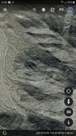
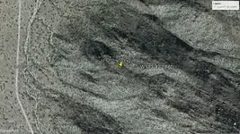
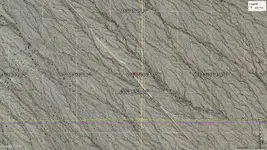
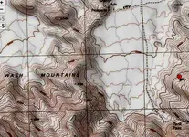
Here is my map with my triangulation lines drawn as I chased the Gold signal to Tank pass..Here is a Treasure lead listed in Thomas P. Terry treasure book, Arizona. I chased a 8 mile Gold signal to the area, rain chased me out. Any Dowsers see anything good. There is a few mines in pic.
Attachments
- Joined
- Jan 1, 2013
- Messages
- 2,664
- Reaction score
- 5,461
- Golden Thread
- 0
- Detector(s) used
- Tesoro Vaquero, Whites MXT, Vsat, GMT, 5900Di Pro, Minelab GPX 5000, GPXtreme, 2200SD, Excalibur 1000!
- Primary Interest:
- All Treasure Hunting
Very cool 😎
It looks like three of your lines are certainly triangulating at a specific point. So you followed all three lines from 8 miles out and they happened to cross like this? The line going from north to south looks like it passed the point where the other two west and east lines were intersecting. Did you actually follow the line that far or were you just marking the general direction of the line on your map? Just curious, interesting work
dowser
Bronze Member
- #5
Thread Owner
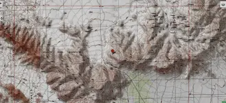
There is 4 triangulation lines. I started at Wenden , set my Gold on the ground, dowse for signal lines. I had 1 line heading NW, i make a line in the ground on that line in that direction. I record the GPS coordinates from where I'm standing, Then I take a compass reading, I transfer my compass reading direction using a protractor, to my map. The next spot I checked for signal was Mcvay. There was a connection line heading NE. I transferred to my map, then I drove to another intersection before Big granite rd. Did the same. I Confirmed Gold target by triangulation. Drove to the end of Butter valley farm rd. Dowsed and transferred to map again. From Wenden to Tank pass is 8 to 9 miles from my first signal. There is something there. One spot that's been missed, hard rock Gold ore I assume. Not my first time chasing Gold signals from a distance. Same thing in Cherry mining district. 1 spot missed in all the mines there, and I dowsed right to it. It was that Mineralized vein I was asking about years back..It looks like three of your lines are certainly triangulating at a specific point. So you followed all three lines from 8 miles out and they happened to cross like this? The line going from north to south looks like it passed the point where the other two west and east lines were intersecting. Did you actually follow the line that far or were you just marking the general direction of the line on your map? Just curious, interesting work
Very nice. Yes there is probably a motherload there waiting to be found. I hope you can get it.There is 4 triangulation lines. I started at Wenden , set my Gold on the ground, dowse for signal lines. I had 1 line heading NW, i make a line in the ground on that line in that direction. I record the GPS coordinates from where I'm standing, Then I take a compass reading, I transfer my compass reading direction using a protractor, to my map. The next spot I checked for signal was Mcvay. There was a connection line heading NE. I transferred to my map, then I drove to another intersection before Big granite rd. Did the same. I Confirmed Gold target by triangulation. Drove to the end of Butter valley farm rd. Dowsed and transferred to map again. From Wenden to Tank pass is 8 to 9 miles from my first signal. There is something there. One spot that's been missed, hard rock Gold ore I assume. Not my first time chasing Gold signals from a distance. Same thing in Cherry mining district. 1 spot missed in all the mines there, and I dowsed right to it. It was that Mineralized vein I was asking about years back..
dowser
Bronze Member
- #7
Thread Owner
Lots of Quartz, lots of Hydrothermal activity signs from the past. It's right in the foothills to the N of the wash. I believe its covered by overburden from the mtn. The old mining activity was to the S. Awesome area heading back in thru the farm, out the back. The ground all the way in is quartz sand. You cross 2 shallow washes. Gool luck anyone heading back. Hope you Metal detect some big nuggets.
Last edited:
xristosz
Jr. Member
- Joined
- Jan 1, 2017
- Messages
- 97
- Reaction score
- 52
- Golden Thread
- 0
- Location
- thessaloniki
- Primary Interest:
- All Treasure Hunting
Red_desert
Gold Member
- Joined
- Feb 21, 2008
- Messages
- 7,164
- Reaction score
- 3,804
- Golden Thread
- 0
- Location
- Midwest USA
- Detector(s) used
- Garrett Ace 250/GTA 1,000; Fisher Gold Bug-2; Gemini-3; Unique Design L-Rods
- Primary Interest:
- All Treasure Hunting
Here is my map with my triangulation lines drawn as I chased the Gold signal to Tank pass..Here is a Treasure lead listed in Thomas P. Terry treasure book, Arizona. I chased a 8 mile Gold signal to the area, rain chased me out. Any Dowsers see anything good. There is a few mines in pic.
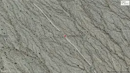
Try checking where the SE line crosses over the SW line. Then go past the SW line until about directly above where W & SW lines are crossed. First time checking, I got a hit in this area.
Red_desert
Gold Member
- Joined
- Feb 21, 2008
- Messages
- 7,164
- Reaction score
- 3,804
- Golden Thread
- 0
- Location
- Midwest USA
- Detector(s) used
- Garrett Ace 250/GTA 1,000; Fisher Gold Bug-2; Gemini-3; Unique Design L-Rods
- Primary Interest:
- All Treasure Hunting
Red_desert
Gold Member
- Joined
- Feb 21, 2008
- Messages
- 7,164
- Reaction score
- 3,804
- Golden Thread
- 0
- Location
- Midwest USA
- Detector(s) used
- Garrett Ace 250/GTA 1,000; Fisher Gold Bug-2; Gemini-3; Unique Design L-Rods
- Primary Interest:
- All Treasure Hunting
Red_desert
Gold Member
- Joined
- Feb 21, 2008
- Messages
- 7,164
- Reaction score
- 3,804
- Golden Thread
- 0
- Location
- Midwest USA
- Detector(s) used
- Garrett Ace 250/GTA 1,000; Fisher Gold Bug-2; Gemini-3; Unique Design L-Rods
- Primary Interest:
- All Treasure Hunting
Red_desert
Gold Member
- Joined
- Feb 21, 2008
- Messages
- 7,164
- Reaction score
- 3,804
- Golden Thread
- 0
- Location
- Midwest USA
- Detector(s) used
- Garrett Ace 250/GTA 1,000; Fisher Gold Bug-2; Gemini-3; Unique Design L-Rods
- Primary Interest:
- All Treasure Hunting
Red_desert
Gold Member
- Joined
- Feb 21, 2008
- Messages
- 7,164
- Reaction score
- 3,804
- Golden Thread
- 0
- Location
- Midwest USA
- Detector(s) used
- Garrett Ace 250/GTA 1,000; Fisher Gold Bug-2; Gemini-3; Unique Design L-Rods
- Primary Interest:
- All Treasure Hunting
Red_desert
Gold Member
- Joined
- Feb 21, 2008
- Messages
- 7,164
- Reaction score
- 3,804
- Golden Thread
- 0
- Location
- Midwest USA
- Detector(s) used
- Garrett Ace 250/GTA 1,000; Fisher Gold Bug-2; Gemini-3; Unique Design L-Rods
- Primary Interest:
- All Treasure Hunting
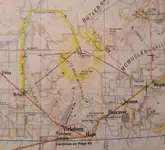
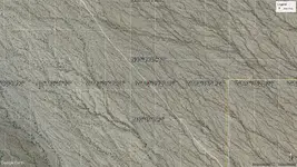
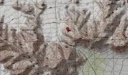
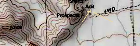
In cropped down topo, looking at 4WD road going up, another comes across west/east direction. Slightly NW near top, print hard to read... think it says "Prospects" where 4WD enters the hills.
dowser
Bronze Member
- #16
Thread Owner
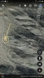
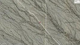
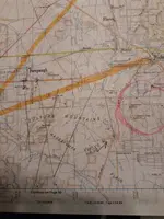
On the same day I Dowsed that treasure lead, I also kept stopping and dowsing toward the Vulture mtns, as I headed towards Wickenburg on 60. I wasn't very precise on triangulation lines not sure on the correct triangle due to multiple targets. I didnt realize till years later, my last Dowsed line ran right to the famous Vulture mine. Still lots of unmined gold in them Vulture mountains.
Attachments
Red_desert
Gold Member
- Joined
- Feb 21, 2008
- Messages
- 7,164
- Reaction score
- 3,804
- Golden Thread
- 0
- Location
- Midwest USA
- Detector(s) used
- Garrett Ace 250/GTA 1,000; Fisher Gold Bug-2; Gemini-3; Unique Design L-Rods
- Primary Interest:
- All Treasure Hunting
Red_desert
Gold Member
- Joined
- Feb 21, 2008
- Messages
- 7,164
- Reaction score
- 3,804
- Golden Thread
- 0
- Location
- Midwest USA
- Detector(s) used
- Garrett Ace 250/GTA 1,000; Fisher Gold Bug-2; Gemini-3; Unique Design L-Rods
- Primary Interest:
- All Treasure Hunting
I would expect, a lot of signals around that area. But there is something upper half, about center, right below line which says divide. Seems to be a couple spots from there moving south.
Last edited:
Red_desert
Gold Member
- Joined
- Feb 21, 2008
- Messages
- 7,164
- Reaction score
- 3,804
- Golden Thread
- 0
- Location
- Midwest USA
- Detector(s) used
- Garrett Ace 250/GTA 1,000; Fisher Gold Bug-2; Gemini-3; Unique Design L-Rods
- Primary Interest:
- All Treasure Hunting
xristosz
Jr. Member
- Joined
- Jan 1, 2017
- Messages
- 97
- Reaction score
- 52
- Golden Thread
- 0
- Location
- thessaloniki
- Primary Interest:
- All Treasure Hunting
Similar threads
Users who are viewing this thread
Total: 1 (members: 0, guests: 1)
