Arizona Dowsed treasure lead

The pin is your gps coords.
 

Attachments

  • Stanton_1920x1080HD-GE-map-C1.webp
    Stanton_1920x1080HD-GE-map-C1.webp
    416.3 KB · Views: 74
  • Stanton_1920x1080HD-GE-map.webp
    Stanton_1920x1080HD-GE-map.webp
    345.4 KB · Views: 73
Better look above pin.
 

Attachments

  • Stanton_1920x1080HD-GE-map-B1.webp
    Stanton_1920x1080HD-GE-map-B1.webp
    386.2 KB · Views: 78
  • Stanton_1920x1080HD-GE-map-B2.webp
    Stanton_1920x1080HD-GE-map-B2.webp
    480.7 KB · Views: 78
  • Stanton_1920x1080HD-GE-map-B3.webp
    Stanton_1920x1080HD-GE-map-B3.webp
    526.6 KB · Views: 67
  • Stanton_1920x1080HD-GE-map-B4.webp
    Stanton_1920x1080HD-GE-map-B4.webp
    648.3 KB · Views: 74
Not much signal at first, but marked something giving hits.
Here's where I dowsed in 2012. Lots of past mining activity to the North is Jerome.. Copper mine
 

Attachments

  • 20211127_211033.webp
    20211127_211033.webp
    608.9 KB · Views: 63
I didn't think about checking for copper. Usually gold/platinum associated with copper mining... is just an extra bonus as a by-product.
 
Old Stanton topo, gives the name for a few of the mines.
 

Attachments

  • Stanton_Topo-map-A.webp
    Stanton_Topo-map-A.webp
    1.4 MB · Views: 69
  • Stanton_Topo-map-B.webp
    Stanton_Topo-map-B.webp
    1,000.3 KB · Views: 67
Pin on topo again is your gps coords. Wonder if that Leviathan mine is close to my hits?
 
Probably not, think Stanton is above this area.
 

Attachments

  • 20211111_101644-Au-crop.webp
    20211111_101644-Au-crop.webp
    83.5 KB · Views: 63
North and west of Brick's Windmill.

I'm adding a topo section, showing hits between the Leviathan mine and Brick's Windmill. A couple places might be up on slopes.
 

Attachments

  • Stanton_Topo-map-Bricks_Windmill.webp
    Stanton_Topo-map-Bricks_Windmill.webp
    523.1 KB · Views: 104
Last edited:
I never knew about the windmill. I had met a previous owner of the Leviathon, Marty. Back before Weaver sold some of their claims, they had one below Leviathon. The whole area from there and over toward Antilope creek is huge boulders below any overburden. There was a 15 deep foot square pit that we saw from old diggins, and they gave up before reaching bedrock.. Lots of Gold below...
 
Well, to me a good explanation for gold hits. I was specifically checking nugget signals. Some nuggets will be still in quartz float or veins.
 
The guy that owned the Leviathon mine, Marty, was a map Dowser. I would take my rods and Omnirange over to his house, and we would go over a Sycamore canyon map, dowsing for the lost Spanish Silver mine legend. He and his buddy were really good. Marley's grandfather was a famous dowser, he had been on Ripleys Believe it or not.. He taught his grandson Marley. He handed down a custom made 3 ft long noodle rod to his grandson. After an target indication with his noodle rod, he would switch to Pendulum to get closer. It was fun, he could dowse a Omnirange signal his way, just as I could my way. But I couldn't get anything off the map, even using his stuff. I saw map dowsing, use of noodle rods, use of Pendulum work!. I like seeing dowsed map spots, I know I can't do it, and I know it can be done..
 
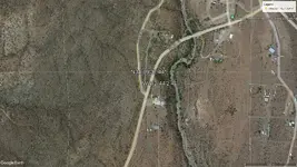
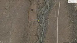
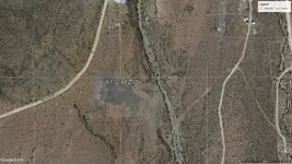
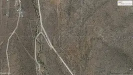
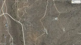
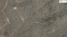
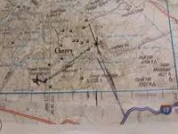
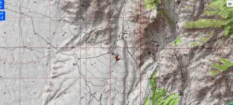
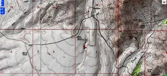
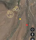
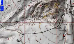
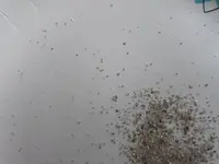
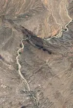
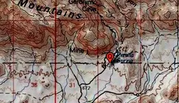
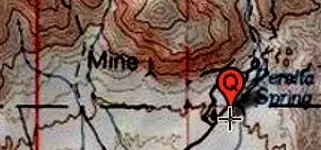
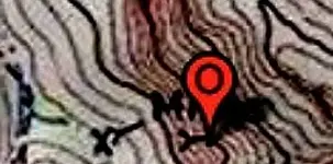
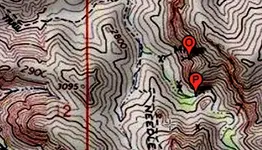
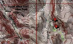
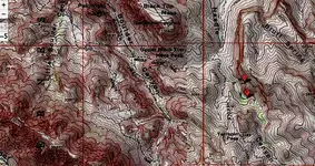
When I first started Dowsing and using Elements to signal with. I carried a single Diamond in a little jar with me. That was my Carbon signal. Here's a pic of my cut diamond, along with some dust/chips I use now along with it. I drove from Stanton over towards the Hassayampa river to long distant dowse, with longer rods. I was dowsing towards the East across the river. I had one Gold target making a line back to my Gold signal. Not expecting any Carbon target to be within reach, I checked anyhow. Yes, my Diamond had signalled a target. Surprisingly it was over near the Gold target from what I could tell. It was 2 weeks before I made it up Constellation road east of the Hassayampa. It was a normal Sunny hot day, and the track was only about 100 yds from the targets. I first went to the Gold target ending up over what I believe was plutonic rock. Not seeing anything on top, I figured an ore vein below. When I dowsed my Diamond, the target was on the adjacent hill, about 50 yds away. It wasn't until I got close that I could see a dark black ore vein 4 inches thick, about 10ft long running horizontal on the hill. At closer inspection I could see it was loaded with mica, i thought. The vein was real hard, and i had to pick up a loose peice. It was the most sparkling pitch black rock I ever saw. At home in the rock book, the closest I could get was mica schist. I never took a close look at it, thought it was mica. I wish I had some more, because I can't find a real match on line. If it was schist, it would be flaking, which this was not, plus I don't remember the mica coming off in my hands.. Part of the reason that I thought it was mica schist is because, Graphite is in it. That seemed to explain the black, and Carbon signal hitting on it. I lost the spot and would like to eventually return. There is some mineral claims in the area. If I could find it on Google earth, I could check for claim ability. If anyone sees a Carbon/Diamond/Graphite target east of the river mark it up. Thanks
 

Attachments

  • 20211130_104004.webp
    20211130_104004.webp
    163.9 KB · Views: 58
  • 20211130_062231.webp
    20211130_062231.webp
    64.2 KB · Views: 64
I have seen black lamproite diamond ore, as it weathers from freezing during winter, the ore turns green, blackish green. then soft a bluish white color.
 
I drove from Stanton over towards the Hassayampa river to long distant dowse, with longer rods
A town got washed away during a flood once, the safe with gold and silver from a town building, is supposed to be in the river.
 
A town got washed away during a flood once, the safe with gold and silver from a town building, is supposed to be in the river.
The town was at Fools canyon, i used to drive down thru the Hassayampa and see peices of plates and junk, dowsing for the safe myself. It wasn't until I met Marley, he said his grandfather had already dowsed and found it. It had tumbled open..
 
It washed away the town and 100 people, mostly miners. The hidden adit or mine entrance I had found, is within 2 miles from there..
 

Attachments

  • 20211130_190800.webp
    20211130_190800.webp
    23.1 KB · Views: 54
Yes, Walnut Grove was the name, just couldn't seem to remember it at the time.
 
Didn't the NF service get old mine locations removed on topo maps certain places or at least in Superstition Mts? Checked on topo a couple areas had map dowsed in past. Says Mine, is the symbol next to mine text represent a shaft?
 

Attachments

  • Map_Topo_PeraltaSprings_1.webp
    Map_Topo_PeraltaSprings_1.webp
    122 KB · Views: 63
  • Map_Topo_PeraltaSprings_1B.webp
    Map_Topo_PeraltaSprings_1B.webp
    26.5 KB · Views: 68
Supposed to be caves/tunnels around Black Top Mesa, were used to store gold from Peralta mines. Did map dowsing years ago, got gps from those maps for making old topo maps. Pins here were the dowsing hits. The quartz vein zone stops before reaching Black Top Mesa. The western most edge is where mine symbols are shown.
 

Attachments

  • Map_Topo_NeedleCanyon_1Cc.webp
    Map_Topo_NeedleCanyon_1Cc.webp
    24 KB · Views: 61
  • Map_Topo_NeedleCanyon_1C.webp
    Map_Topo_NeedleCanyon_1C.webp
    233.1 KB · Views: 71
  • Map_Topo_NeedleCanyon_1B.webp
    Map_Topo_NeedleCanyon_1B.webp
    226.6 KB · Views: 57
  • Map_Topo_NeedleCanyon_1.webp
    Map_Topo_NeedleCanyon_1.webp
    779.1 KB · Views: 63

Users who are viewing this thread

Latest Discussions

Back
Top Bottom