I found this, maybe it can help looking up the field data...
http://msuinvasiveplants.org/documents/archives_cism/BLM_Measuring_and_monitoring.pdf
4. Landmark references
All monuments should be supplemented with references to visible permanent landmarks.
Obvious landmarks on the site, such as a rock outcrop, can be used to identify the location of
monuments. Directions from the landmark to the monument should include both measured
distance and compass direction (note whether declination or magnetic). A photograph of the
landmark from the monument that includes the monument in the foreground helps in
relocation.
On sites lacking nearby landmarks, triangulation can be used to identify the location of a
monument in relation to distant landmarks. This involves measuring the compass direction
toward landmarks such as mountain tops and permanent (you hope) man-made objects such
as water towers or microwave towers. By measuring the direction to two objects, your location on the ground is fixed by the angle formed by those objects and your location. The site
can then be relocated in the future. Triangulation is most accurate when the angle formed by
the two triangulation points is approximately 90°.
5. Adding "insurance"
No monuments that are required for continuation of the study (e.g., permanent quadrat
corners or transect ends) should be without insurance in case the primary monuments are
lost. One option is to bury physical markers such as large nails or stakes. A single buried nail
next to a monument may be disturbed or dug up when the monument is disturbed. Better
insurance is to use four buried nails, each exactly 1m from the primary monument on the
four compass directions. A metal detector can then be used to locate the nails if the primary
monument is removed.
A second option is to survey the primary monument using survey or forestry grade survey
instruments. You can survey the monument from a permanent known point or from two or
more inconspicuous secondary monuments
4. Field notebooks and data sheets
While data from most monitoring studies will be collected on pre-printed data sheets (see
Chapter 9), field notebooks will still be needed to keep a record of general observations and
notes. It is strongly recommended that you keep a field notebook as a log of daily field
activities. Field notebooks are also necessary for recording information on plant collections
(see Section P)
B. Recording Data in the Field
Three options exist for gathering ecological monitoring data in the field: (1) tape recorders, (2)
portable computers or data loggers, or (3) field data forms or field notebooks. The use of field
data forms is covered in more detail than other methods since field data forms are still the most
common way that field data are gathered.
Each set of data should have a cover sheet that stays with the field data at all times
The cover sheet should provide information on what, why, where, who, how, and when types
of information. Detailed information should be provided on the location of study plots, the
species or community being studied, the personnel involved, the types of management treatments that have occurred or are being planned, a description of any codes that are used, and
a thorough description of the field methodology. See Figure 9.1 for a list of the types of
information that should be included on the cover sheet, and Appendix 15 for a blank field
monitoring cover sheet. In addition, each field data form should have a complete "header"
section that links the form to the project described on the cover sheet. The header should be
completely filled out on every page. The header should include at least the following items:
1. Date.
2. Location (general area and specific sampling location).
3. Title/project description.
4. Species or community name.
5. Treatment category (if applicable).
6. Observer (person(s) doing the sampling).
7. Transect or macroplot number (if this information applies to entire data sheet).
8. Page number _____ of _____ total pages.
9. Room for additional comments.
C. Entry and Storage of Data in the Office
If the quantity of data gathered is small, sometimes the data can be efficiently summarized
straight off the field data form using a hand calculator. Calculations should be repeated, to
ensure that no mistakes were made in entering and summarizing the data. Often, however, monitoring data will need to be input into a computer system for data summary and analysis. If the
data were gathered on a portable computer, then the data are ready to go. If, however, the data
were gathered on field data forms or with a tape recorder, then data entry is the next step. This
topic is divided into the following five sections: (1) selecting a computer software program, (2)
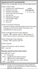
storing data files–filenames and directories, (3) adequately documenting data files, (4) proofing
entered data sets, and (5) making backups of entered data.
3. Adequately
documenting data
files
Each data file should
include reference information about the data in
that file (Stafford 1993).
This information should
detail the how, when,
what, where, and who
information included in
the field data cover sheet
and in header sections of
the field data forms. This
kind of information
should be included in a
file header that appears
in the computer file
above the rows of actual
monitoring data. Any
codes contained in the
data set should be listed
and described in the file
header. A detailed
description of the methods
used to gather the data
should be included in the
file header or a reference
to another source for this
information should be
provided. See Figure 9.3
for an example of a
completed data file
header.


