Prairie Gazingfox
Sr. Member
- Joined
- Feb 18, 2025
- Messages
- 377
- Reaction score
- 430
- Golden Thread
- 0
- Location
- North Illinois
- Detector(s) used
- Pendulum
- Primary Interest:
- All Treasure Hunting
- #1
Thread Owner
The sound of an owl or something similar made me go across some patches of thorns , small dried up rivulets ,and descend another 80 yards towards the roaring highway.
Something like a huge egg shape stone caught my eye. Standing all by itself.
I had not with me my prescription glasses. 4 pm passing. It would be dark by 6 pm.
I said to myself " this Stone about 4.5 feet long and 2. 5 feet tall got to have been reshuffled when they were building the highway around 1960. Then I realized that the young forest and mostly brushes had totally pristine look. No concrete fragments. Absolutely not a sign of broken glass, etc. Just here and there some old glass bottles.
It was further down from where used to be Arable land, many acres, just maybe 100 yards further down.
The 1938 Arial photo shows quite murky terrain below where the Arable land was.
The closest square showing a structure In 1938 is 300- 350 yards away. Surrounded by rectangular parcels.
I suppose part of the Murky immediate Acreage ( maybe 20 acres ) around the Boulder is due to the presence ofva little bit older and denser forest stripe that used to be
But those original Silver nitrate or whatever films have been stained by people's hands prior to have been replicated after the 60s. Multiple times maybe.
Anyway, I kind of observed from 20 meters that the Boulder kind of Most likely points East.
Later I understood it is Granite. No moss also.
I spotted 2 small Stones embedded into the ground what seemed Almost on opposite Compass side of the Boulder.
Decided not to limit myself mentally to this side only. But when I started swinging the Pendulum ( from about 7-8 meters away from any markings, It kept pulling me to where I believe the Cache spot is !
Used only 4 elements to dowse the area with. Not enough time for Lavish indulgence.
All 4 kept pulling with 70- 80 % of max Pull toward a point that I realized Is actually Neither quite opposite the stone Nor quite at 90 degrees
I started shocking myself with thoughts : There is no Moss onto any of the markings, in fact the small elongated one is sticking diagonally AND towards the sky. I easily pulled it out ! I said to myself: " This could have been embedded 20 years ago or maybe 30- 40 max !
I returned it into the ground.
Then I realized all Lenghts of swing for Copper, Silver, Aluminium are sippressed 50 % At that Spot. Just Aluminium is Slightly weaker. But at the end after I started measuring with the tape measure and Realized Distance from Main Marker ( Boulder) to the Assumed Cache Spot is exactly 30 FEET and 6 inches; Distance from the Elongated Marker in the middle the Tape showed exactly 25 feet; Distance from the 2 possible corners of the 3rd marker was 18 feet .
I remeasured all 3 Trajectoriies again. Same thing : 30 feet, 25 feet, 18 feet.
I got mad about the 18 feet not being 20 feet. But I realized this thing is probably Deep and MAYBE the owner messed up by 1 or 1.5 feet when burying it .
Plus this marker is the shallowest HEIGHT..I said to myself: Maybe some treasure hunter moved it last several decades.....
So i measured with Lead : the Swing was a little more Relaxed (.no high resistivity ) than those of Silver and Copper.
But those two are also relatively Almost TOTALLY SMOOTH WITHIN the principles of my method. Just subdued.
Also Pb showed 1 finger Thickness Longer swing. From 2 different angjes. Longer than Silver.
I didn't measure with other metals, No time.
Pb also was more Spontaneous than with Aluminum. But difference in Lenght was Very very minimal.
I walked witg the manual compass Above the Spot 5 or 6 times. NO ANY DEVIATION of the floating arrow.
1 or 2 times MAYBE I noticed 1 mm tilt. But from what I read, No sudden deviation means NO IRON OBJECT undernesth. ??
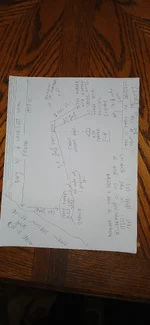
Here is the drawing.
My Pendulum later from home determined Depth of 65 to 85 centimeters. Sorry, i am from Europe.easier to Visualize.
PS after I tape measured all Lines, at the very end I noticed a 4th flat small stone It was Straight SOUTH from the Assumed Spot according to the Compass. And it was POINTING STRAIGHT at 12 O'clock downhill where I had Stuck a wooden stick.
This 4th marker I didn't measure Distance of But visually appeared to be neitger 20 feet nor 25 feet.
And it Has A LITTLE moss.
None of the others have moss !!!!
No big trees anywhere within 20 yards .Just several of 8 to 10 inch stems.
I headed back out. Didn't return.
I don't have access to the Estate maps anymore but saved some on my phone this Spring.
The Area does NOT Show farm or structure even in the 1861 map. Neither in the Subsequent printings.

..

Something like a huge egg shape stone caught my eye. Standing all by itself.
I had not with me my prescription glasses. 4 pm passing. It would be dark by 6 pm.
I said to myself " this Stone about 4.5 feet long and 2. 5 feet tall got to have been reshuffled when they were building the highway around 1960. Then I realized that the young forest and mostly brushes had totally pristine look. No concrete fragments. Absolutely not a sign of broken glass, etc. Just here and there some old glass bottles.
It was further down from where used to be Arable land, many acres, just maybe 100 yards further down.
The 1938 Arial photo shows quite murky terrain below where the Arable land was.
The closest square showing a structure In 1938 is 300- 350 yards away. Surrounded by rectangular parcels.
I suppose part of the Murky immediate Acreage ( maybe 20 acres ) around the Boulder is due to the presence ofva little bit older and denser forest stripe that used to be
But those original Silver nitrate or whatever films have been stained by people's hands prior to have been replicated after the 60s. Multiple times maybe.
Anyway, I kind of observed from 20 meters that the Boulder kind of Most likely points East.
Later I understood it is Granite. No moss also.
I spotted 2 small Stones embedded into the ground what seemed Almost on opposite Compass side of the Boulder.
Decided not to limit myself mentally to this side only. But when I started swinging the Pendulum ( from about 7-8 meters away from any markings, It kept pulling me to where I believe the Cache spot is !
Used only 4 elements to dowse the area with. Not enough time for Lavish indulgence.
All 4 kept pulling with 70- 80 % of max Pull toward a point that I realized Is actually Neither quite opposite the stone Nor quite at 90 degrees
I started shocking myself with thoughts : There is no Moss onto any of the markings, in fact the small elongated one is sticking diagonally AND towards the sky. I easily pulled it out ! I said to myself: " This could have been embedded 20 years ago or maybe 30- 40 max !
I returned it into the ground.
Then I realized all Lenghts of swing for Copper, Silver, Aluminium are sippressed 50 % At that Spot. Just Aluminium is Slightly weaker. But at the end after I started measuring with the tape measure and Realized Distance from Main Marker ( Boulder) to the Assumed Cache Spot is exactly 30 FEET and 6 inches; Distance from the Elongated Marker in the middle the Tape showed exactly 25 feet; Distance from the 2 possible corners of the 3rd marker was 18 feet .
I remeasured all 3 Trajectoriies again. Same thing : 30 feet, 25 feet, 18 feet.
I got mad about the 18 feet not being 20 feet. But I realized this thing is probably Deep and MAYBE the owner messed up by 1 or 1.5 feet when burying it .
Plus this marker is the shallowest HEIGHT..I said to myself: Maybe some treasure hunter moved it last several decades.....
So i measured with Lead : the Swing was a little more Relaxed (.no high resistivity ) than those of Silver and Copper.
But those two are also relatively Almost TOTALLY SMOOTH WITHIN the principles of my method. Just subdued.
Also Pb showed 1 finger Thickness Longer swing. From 2 different angjes. Longer than Silver.
I didn't measure with other metals, No time.
Pb also was more Spontaneous than with Aluminum. But difference in Lenght was Very very minimal.
I walked witg the manual compass Above the Spot 5 or 6 times. NO ANY DEVIATION of the floating arrow.
1 or 2 times MAYBE I noticed 1 mm tilt. But from what I read, No sudden deviation means NO IRON OBJECT undernesth. ??
Here is the drawing.
My Pendulum later from home determined Depth of 65 to 85 centimeters. Sorry, i am from Europe.easier to Visualize.
PS after I tape measured all Lines, at the very end I noticed a 4th flat small stone It was Straight SOUTH from the Assumed Spot according to the Compass. And it was POINTING STRAIGHT at 12 O'clock downhill where I had Stuck a wooden stick.
This 4th marker I didn't measure Distance of But visually appeared to be neitger 20 feet nor 25 feet.
And it Has A LITTLE moss.
None of the others have moss !!!!
No big trees anywhere within 20 yards .Just several of 8 to 10 inch stems.
I headed back out. Didn't return.
I don't have access to the Estate maps anymore but saved some on my phone this Spring.
The Area does NOT Show farm or structure even in the 1861 map. Neither in the Subsequent printings.
..
Attachments
Last edited: