Hal Croves
Silver Member
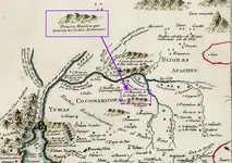
The symbols that I point out are not shown on your version.
I wonder which is the initial map and which has been edited?
Either way, something has been added or removed.
In a location that seems related to the topic.
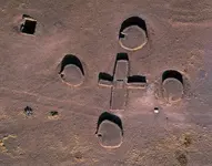
Thanks, Hal great question, I have thought about that a lot. There are about four things, that are important, to whoever finds it. #1 My guys are the most honest above board guys you will ever meet, almost to a fault. If any of them are buying something somewhere and they get charged the wrong price( too low), they will let the clerk owner of the shop you did not charge or collected the wrong amount, you are going to be short. We have talked at length about protecting the historical, entities, on-site. We will not take anything but photographic evidence, with the exception of a small sample of loose gold, for verification purposes. #2 One thing I can guarantee, by us finding it, is nothing will be taken. But we will document what is there on film. ( I really do not trust people at the Park Service) Buy us finding I can guarantee, the site will be respected. Also, the site is in a location that takes equipment and training to get to and eliminates 98% of the people out there. #3 Casa Grange is known and protected and monitored, this site is historically as important and will be monitored, IMO. # If we have what we think we have, it needs to be protected, and can be, but also shared with the world. In theory, keeping it secret, is great as long as people that care like you and others on this site are the ones who would keep it a secret are the ones who find it. But if the wrong group finds it, things could be lost forever. So it is a dammed if you do and dammed if you do not. I actually really have a concern, about the park service, what are your, thoughts there. I have not talked about this to the team but has entered my thoughts that if there are historical artifacts, to turn in on Phoenix TV so they are documented for everyone to see so nothing comes up missing. Of course have someone like the Dutchman Muesum there at the time, or the Arizona historicle society. I just do not trust the park service, what are your thoughts. I want my grandchildren to see these things after I am gone.
The Park Service follows policy.
Knowing what those are is your advantage.
The symbols that I point out are not shown on your version.
I wonder which is the initial map and which has been edited?
Either way, something has been added or removed.
In a location that seems related to the topic.
The symbols that I point out are not shown on your version.
I wonder which is the initial map and which has been edited?
Either way, something has been added or removed.
In a location that seems related to the topic.
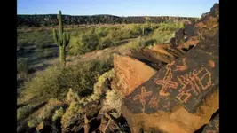
The upper canyon section of the Gila has turned up lots of Meso -0 American inanities and it has been barely explored, and I can almost guarantee, there is a wealth of things there that point to a Meso-American- presence. If I was 40 years younger I would have that on my list to do next.
The land of those who bear crosses ?
Could be .
Small area, and just north of the Gila in Mineral Mountains.....so kinda sounds exclusive or enclave-like.
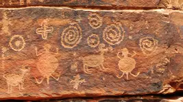
Plenty of bordered cross petroglyphs on rocks on that side of the river out there too. Cochran town site, Coke Ovens, Stone House, stone walls, smelter and ruins marked on other old maps. All clustered north and south, surrounding that part of the Gila......also the "scrapings" not far to the NW.
One old map even has that same area labeled "Aztlan".
I thought the same thing...land of the cross-bearers...very interesting stuff. Have you seen the story that Tevis was given by Esconolea about what was an apparent unknown Spanish incursion into that area? He actually took Tevis up to see the place.
Things definitely get more interesting further up the Gila, although my post may have been a little confusing in that regard.
The land of those who bear crosses ?
Could be .
Small area, and just north of the Gila in the "big bend" area.....so kinda sounds exclusive or enclave-like.
Plenty of bordered cross petroglyphs on rocks on that side of the river out there too. And a place called "Fortaleza", a hilltop ruin. ...
Nope. The Grand Canyon caves, but not about anything around the Gila.
Gotta get to work though....so I'll have a look when I get back home.
Jeff, thank you, but I know next to nothing about this subject. Careful with the Tevis story, it does not make sense. Hopefully some more knowledgeable posters can address it. What I can tell you is that the limited research I've done on Tevis indicates he is remarkably accurate in his recollections. Tevis himself seems perplexed by the story. I can't even tell if "Montezuma City" really is/was in the Verde Valley. To me it sounds like they were somewhere else. It certainly is a strange story!
Tevis is usually a reliable fact guy but Esconolea may have greatly exaggerated the Natives' oral memories recounting an early Spanish incursion. The Grand Canyon snippet was interesting. I have a military scouting report somewhere that may validate the mining ruins account upriver from the Rio San Francisco's mouth. As I recall, the cavalry found old placer workings while chasing Apaches.
With "those who bear crosses", are you referring to Christian crosses or the cross pattèe, such as those shown on the map (but not noted in the legend)?
Victor,
The Princeton map you posted appears to have more information than the one Wayne posted. If you look at the bottom of the Princeton map, the reason for the map is explained. Rough translation from French:
“Since receiving this map, the voyage of Monsieur Chappe to California took place to procure the corrections of different positions of interest indicated here.”
If you look at the towns of New Veracruz, Mexico, and St. Joseph below that, new longitudes and latitudes are given “in lieu of” (au lieu de) the old ones. So the positions were re-charted.
The map SH posted omits the reason for the changes (the voyage of M. Chappe), but still gives the corrections.
The abbreviation for Rio is:
View attachment 1745156
Not sure which map came first, they just look like copies of the same map.


Esconolea's description of incursion of Apache lands to James Tevis, and their trip to the area, attached. Excerpt from "Arizona in the '50's" (1850's) by James H. Tevis, 1954.
View attachment 1745188
hi paul...good to see you backI've always found that story intriguing