David and the Peralta stone maps.

BenThereDoneThat

Sr. Member
Feb 27, 2008
277
8
Apache Junction, AZ
Detector(s) used
MXT 300 / Javelina Gold Trommel
Primary Interest:
All Treasure Hunting
Quinan Bear said:
Tayopa:
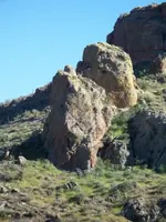
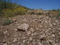
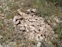
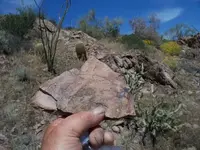
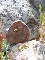
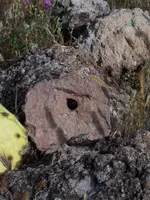
I would like to show you something about the stones that nobody has seen althought it is in plain sight but before I say any more, I have a question.
Is there any of you that are capable of seeing the stones in person?

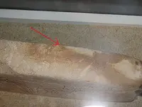
Ill show you something that you possibly didnt know...........Writing on the side of this stone map!
 

Attachments

  • HorseMapa.jpg
    HorseMapa.jpg
    159.6 KB · Views: 804

somehiker

Silver Member
May 1, 2007
4,365
6,426
Primary Interest:
All Treasure Hunting
Maybe this view will help.

Regards:SH
 

Attachments

  • 100_0461sm.jpg
    100_0461sm.jpg
    84.7 KB · Views: 748

somehiker

Silver Member
May 1, 2007
4,365
6,426
Primary Interest:
All Treasure Hunting
The width and the depth of the engraving varies throughout the maps.
An outcropping of stone that matches the stone that was used for the heart itself.
This can be found at the base of the Priest.

Regards:SH.
 

Attachments

  • 100_0572sm.JPG
    100_0572sm.JPG
    140.1 KB · Views: 733

somehiker

Silver Member
May 1, 2007
4,365
6,426
Primary Interest:
All Treasure Hunting
A sample that I took to the museum to compare,two weeks ago.
Regards:SH
 

Attachments

  • 100_0568sm.jpg
    100_0568sm.jpg
    73.5 KB · Views: 742
OP
OP
Quinan Bear

Quinan Bear

Sr. Member
Nov 7, 2008
312
6
Grande Prairie Alberta
OK, then what about the other heart?
That one was made of another type as well.

Even though you might have the same type stone, don't mean that your at the same rocks that is at the place that the heart guides you too.
 

somehiker

Silver Member
May 1, 2007
4,365
6,426
Primary Interest:
All Treasure Hunting
Quinan Bear said:
OK, then what about the other heart?
That one was made of another type as well.

Even though you might have the same type stone, don't mean that your at the same rocks that is at the place that the heart guides you too.

In that photo I am standing a the foot of the Priest.From that location you must go next to the Horse,at the base of which you will find the big,flat faced rock that is square on one end and has rounded corners on the other end.There is an inclined cross carved on the back side of this rock that points to the trailhead in a narrow cut.Looking back from that cut,you will see a large "E".Only there can you begin the final trail to the Heart itself by following the Trail Stone pair,the visual references as seen from each viewpoint and a unique set of markers,made from small flat stones similar to the heart stone,each with a hole and a directional "V" carved on one face.I returned home last week,after a two week trip of which 11 days were spent hiking and photographing this area of the mountains and one day at the map discovery site and the museum.I am still reviewing my notes and materials,but it was my most productive trip so far.Exhausting though.

Regards:SH.
 

Attachments

  • marker stone.jpg
    marker stone.jpg
    56.5 KB · Views: 715

somehiker

Silver Member
May 1, 2007
4,365
6,426
Primary Interest:
All Treasure Hunting
It is said that the other "Latin Heart" was made from a brittle black stone.That material,as well as stone of the same types as all the other maps can be found at various locations along the route.

Regards:SH.
 

somehiker

Silver Member
May 1, 2007
4,365
6,426
Primary Interest:
All Treasure Hunting
Not a fluke.Marker without the "V".Number 18 I assume,since from this point you can look down on a very large and tall mound of small broken rock and dirt about twenty feet high at it's highest point.Overgrown and undisturbed,it's an interesting sight and totally uncharacteristic of the surrounding terrain.

Regards:
SH.
 

Attachments

  • 100_0618sm.jpg
    100_0618sm.jpg
    140 KB · Views: 708

Cubfan64

Silver Member
Feb 13, 2006
2,986
2,790
New Hampshire - USA
Detector(s) used
Fisher CZ21, Teknetics T2 & Minelab Sovereign GT
Primary Interest:
All Treasure Hunting
Somehiker - your ability to find unique and highly interesting things in your exporations into the Supers never ceases to amaze me! I need to coordinate a trip to be there at the same time as you and tag along :)
 

somehiker

Silver Member
May 1, 2007
4,365
6,426
Primary Interest:
All Treasure Hunting
I mentioned the "E" that can be seen when standing over the first marker.This is only one of the clues that tie the maps together as a linked set.Looking back toward the "E" below the Horse's tail (as carved on the Horse Map)from the first marker with the "V" in the narrow gap.The trail then goes over a drop off toward the next marker.In this photo,my position is where the "S" or "8" is carved on the Horse map.Note the shape of the rock formation that features the "E"... Also note the lack of a crossbar in the "A" of the word "PASTO" on the original Horse Map.Without the crossbar,the letter "A" becomes an inverse "V".

Regards:SH.
 

Attachments

  • 100_0347sm.jpg
    100_0347sm.jpg
    103.7 KB · Views: 714

somehiker

Silver Member
May 1, 2007
4,365
6,426
Primary Interest:
All Treasure Hunting
Hi Paul:
October at Rendevous time sound good?
We can take a hike,get some fresh air and sunshine and maybe check out a big cave that a set of stone crosses,when arranged in the proper manner,point the way to.I wasn't able to get there this trip....too hot on my last day and it's very rugged.It's not far from that big mound of rock but the trail goes up and down and up and down and...... :P.Got a suspicion that that is where the more fragile artsy type stuff was stashed.
Had a nice visit with Jim at the ranch with the man-eatin dogs on my last day.Also did the tour of MD Helicopters with Kurt and Jim....no test pilot available for a ride this time,though.I volunteered,but I think that they thought I was jokin....Musta been the silly grin.

Regards:Wayne
 

somehiker

Silver Member
May 1, 2007
4,365
6,426
Primary Interest:
All Treasure Hunting
A closeup of the material that was hauled in to create the mound.Very few rocks larger than fist sized and a lot of dirt as well.
Looks like the dirt contains a lot of reddish powdered rock and chips.Probably what gives it the reddish border on the sat view,as it washes out.
Last pic for now.Gettin late.
 

Attachments

  • 100_0653sm.jpg
    100_0653sm.jpg
    107 KB · Views: 678

cactusjumper

Gold Member
Dec 10, 2005
7,754
5,389
Arizona
Here are a few pictures of the Horse Map:

IMG_1335.jpg
IMG_1337.jpg

IMG_1338.jpg
IMG_1339.jpg

IMG_1340.jpg


Horse.jpg


The first five pictures are part of what we took while left alone with the Stone Maps. No Glass, just the stones. I have a number of pictures of Carolyn holding the heart. My pictures can be blown up to just over 200%.

The last picture is from an extensive set (on a CD) professionaly taken under different lightning conditions. All of those pictures can be blown up to around 400%. Makes for very close inspection of the markings.

Joe Ribaudo
 

ghostdog

Sr. Member
Apr 22, 2007
286
15
sh,the rock next to the E rock looks like a skull rock,to me,if it is ,could that mean a marker like a grave or buried crpt.Just random thoughts. Now Q bear, I to am disabled person,ear drums blown out, and I am definitly not the wealthyist,person on this forum,but when I wanna do something,I find a way to do it. Just maybe you could get a hover-round from a charity and convert it to a rock climber,outfitted for the mts. In fact you could end up a poster boy for all hover-round users. Write the various airlines for a free ticket, and petition a hotel for free stay time,just cut all donaters in on a piece of the recovery.When you get to the mts let me know, I bring some extra batterys for your hoverclimber.After that we can head out to Tumincari and find old man Kinko"s stash.
 

somehiker

Silver Member
May 1, 2007
4,365
6,426
Primary Interest:
All Treasure Hunting
ghostdog said:
sh,the rock next to the E rock looks like a skull rock,to me,if it is ,could that mean a marker like a grave or buried crpt.Just random thoughts. Now Q bear, I to am disabled person,ear drums blown out, and I am definitly not the wealthyist,person on this forum,but when I wanna do something,I find a way to do it. Just maybe you could get a hover-round from a charity and convert it to a rock climber,outfitted for the mts. In fact you could end up a poster boy for all hover-round users. Write the various airlines for a free ticket, and petition a hotel for free stay time,just cut all donaters in on a piece of the recovery.When you get to the mts let me know, I bring some extra batterys for your hoverclimber.After that we can head out to Tumincari and find old man Kinko"s stash.

I didn't look around the "E" for signs of buried items,but evidence of such can be found in places indicated on all of the stones,including the Latin Heart.Some of these were easier to find than others.I mainly looked for features that could be recognized when using the maps like one would use a paper map with illustrations such as many "tourist" maps have.Cartographers often included such illustrations on their maps as well.
Some of the trail segments and especially the balance of the markers(all close to the ground on single layers of stones) were difficult or impossible to follow,due to rockslides on the "Peligroza" trail as well as the knee-high thicket of grass and brush that abounds out there right now.Game trails confuse the issue as well,although these are usually very narrow.
One cache location that was easy to locate and match.This one is shown on the Priest map.

Regards:SH.
 

Attachments

  • 100_0554cache.jpg
    100_0554cache.jpg
    132.5 KB · Views: 634

Top Member Reactions

Users who are viewing this thread

Top