David and the Peralta stone maps.

somehiker

Silver Member
May 1, 2007
4,365
6,426
Primary Interest:
All Treasure Hunting
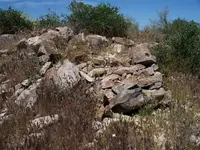
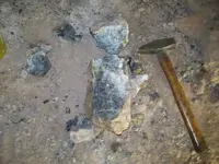
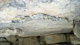
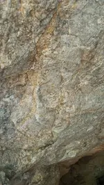
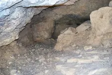
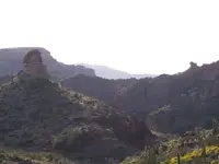
Most of the Priest that is not natural is made up of low walls and piles of stone such as this.Meant to be recognized from a high observation point along the trail from the south,the rockpiles are enhanced with white-faced rock from a nearby source.The white layers are a thin,white crystaline quartz and the white surface was placed outward.

Regards:SH
 

Attachments

  • 100_0558sm.jpg
    100_0558sm.jpg
    110.5 KB · Views: 627

somehiker

Silver Member
May 1, 2007
4,365
6,426
Primary Interest:
All Treasure Hunting
Another pile of rock,and a feature of the Priest map.

SH.
 

Attachments

  • 100_0555sm.jpg
    100_0555sm.jpg
    108.8 KB · Views: 623
OP
OP
Quinan Bear

Quinan Bear

Sr. Member
Nov 7, 2008
312
6
Grande Prairie Alberta
Nice pics SH.
thanks for sharing.

Those small piles of rock could be a number of things. A grave, cache or just a pit someone dug while looking for another mine.
If these pits were the remains of gold mines, wouldn't they have more rocks around then that and wouldn't you also see Quartz?
Did you think of getting a small "sample" stone and have it tested for indicators ?

cactusjumper;

That "priest sitting" that you posted. Does it have black mesa behind it and the goldfields below to the right?
Is this the only place "around" black mesa that has this rock formation?


I have added this pic, to show the priest on the left, the cross with the heart together (there is also a full heart to the east of this picturethat faces the same way) on the same range "Black mesa" and Black top mesa is the circle or ring. Notice how they all point to the Black top mesa .
So the priest is pointing to the marker with his cross and the Heart has the marker on its left side "as shown on map" and the cross has the marker on its top end " as shown on map". then their point of interest is BTM. All this can be seen from atop Weaver's Needle.
If i read the map right there is a mine to the west of the cross's west point and one at it's top point to the south. There should be a tank on the right hump of the heart and near there is a mine. In the middle, just above the "V" of the heart, is another tank and another mine near by.
((tanks and mines are not shown)).
 

Attachments

  • Preist MAp google.jpg
    Preist MAp google.jpg
    163.1 KB · Views: 856

Loke

Hero Member
Mar 24, 2010
589
1,383
Republic of Texas
Primary Interest:
All Treasure Hunting
Quinan Bear said:
...
That "priest sitting" that you posted. Does it have black mesa behind it and the goldfields below to the right?
Is this the only place "around" black mesa that has this rock formation?
...
I have added this pic, to show the priest on the left, the cross with the heart together (there is also a full heart to the east of this picturethat faces the same way) on the same range "Black mesa" and Black top mesa is the circle or ring. Notice how they all point to the Black top mesa .

And here was I thinking that by now - Black Top Mesa must be more akin to Swiss cheese than anything else ... ;-)
 

cactusjumper

Gold Member
Dec 10, 2005
7,754
5,389
Arizona
Loke,

Hope all is well with you and yours.

The list of names of those who have searched Black Top Mesa, would include a large number of my friends and family. It would also be a very long list.

That being said, there is a cave on the north side of the Bull Pass Trail, in the area north of where Ruth's bones were found, that few people know about, and I don't believe it has ever been noted in anyone's book. :dontknow:

Despite that, it is not unknown. Black Top Mesa has been searched, extensively, for years. Those searches began well before Barry Storm wrote his first book.

I believe, for all intents and purposes, it IS "Swiss cheese".

Couldn't have said it better myself. :icon_thumright:

Take care,

Joe
 

OP
OP
Quinan Bear

Quinan Bear

Sr. Member
Nov 7, 2008
312
6
Grande Prairie Alberta
Cactusjumper;

I agree with you that, Black top mesa has many holes.
I was just pointing out what the 1st stage was and where you needed to be to see that 2nd stage, that's all.
 

OP
OP
Quinan Bear

Quinan Bear

Sr. Member
Nov 7, 2008
312
6
Grande Prairie Alberta
I read somewhere that there was, a triangle, creasent moon and circle, that marked the entrance to a cave. Have any of you heard or read about this? I was just wondering because I found a place that shows me these marks. they are not far from a mine in the area and i place that i am studying.

Here is a diagram of what i see.
 

Attachments

  • triangle cresent moon circle.jpg
    202.2 KB · Views: 518

somehiker

Silver Member
May 1, 2007
4,365
6,426
Primary Interest:
All Treasure Hunting
David:
A gentleman by the name of Ron Eagle has been publishing a series of articles in the "Territorial News" as of late.
"http://www.territorialnewspapers.com/aboutus/index.html"
He also claims to have solved the Stone Maps and the articles have many pictures of symbols such as you describe.
He can be reached at 480-626-5994.
He may be able to tell you what the symbols mean.

Regards:SH.
 

OP
OP
Quinan Bear

Quinan Bear

Sr. Member
Nov 7, 2008
312
6
Grande Prairie Alberta
Nice article on the stones but I can't see why someone would make so many maps, all pointing to the same place. I think this was a cache, maybe even Jacob Waltz's cache. I don't think that the stones pointed to that place.
Was there i write up on how the stones matched the area? are there any photos of the, horse, priest and heart other then what was in the paper ?
 

somehiker

Silver Member
May 1, 2007
4,365
6,426
Primary Interest:
All Treasure Hunting
I,myself have only read the last two chapters of the series.You will have to use the archives to go back and read the rest of the story.The April 7 edition(volume 14--#7),which I picked up while I was down there,has a photo of a group of rocks that Mr. Eagle claims is a horse,priest and heart.He certainly has every right to offer his solution,as you do with yours and I do with mine.

Regards:SH.
 

somehiker

Silver Member
May 1, 2007
4,365
6,426
Primary Interest:
All Treasure Hunting
This is what can be seen hanging on the wall at the back end of a cave that is one of several where the "5" and dots are located on the Horse map.
Some has a thin coating of volcanic tuffa,as does much of the several types of rock inside,and some does not.At first,I thought that it was a big bee's nest but it turned out to be one of the most unusual mineral deposits that I have ever come across out there.

SH.
 

Attachments

  • 100_0484sm.jpg
    100_0484sm.jpg
    80.9 KB · Views: 510

somehiker

Silver Member
May 1, 2007
4,365
6,426
Primary Interest:
All Treasure Hunting
I'm not sure if the average prospector would bother to break rock that appears to be worthless tufa,like the rock that the hammer is laid upon,but I was curious.
Turned out to be a quartz material of some kind.This photo was taken during a re-visit to the cave with the drift that I made in order to obtain more grab samples.This cave is one of a number of caves and abandoned mines in an area not far from the heart mound.

SH.
 

Attachments

  • 100_0522sm.jpg
    100_0522sm.jpg
    77.1 KB · Views: 505
OP
OP
Quinan Bear

Quinan Bear

Sr. Member
Nov 7, 2008
312
6
Grande Prairie Alberta
Somehiker;
Thank you for the great pictures. We call that a smokey blue quartz, It should be quite brittle and look like it's wet but isn't. The mineral formation is the cause of the way that the area cooled.
Does the quartz shine, blue, green, yellow, like a peacock's tail, this happens when the quartz cools a certain way.


What direction does the vein run in comparison to the rock's direction? could you describe their path to me in regards to the superstitions, is it a horizontal vein or vertical vein? Am i right in assuming that the rocks are horizontal and the vein is vertical?

Here are 2 pics of labradorite for you to see. this is a very beautiful type rock, used by spain to make floor tiles 2ft square and as you walk down the hall, the floor changes colors, quite pretty really.
 

Attachments

  • 664px-LabradoriteAMD.jpg
    664px-LabradoriteAMD.jpg
    109.1 KB · Views: 449
  • 800px-LabradoriteOslo.jpg
    800px-LabradoriteOslo.jpg
    117 KB · Views: 471
OP
OP
Quinan Bear

Quinan Bear

Sr. Member
Nov 7, 2008
312
6
Grande Prairie Alberta
If this was Jacob's mine, then why didn't he ever mention the stones? or the other caches that were near by.
Did they find a grassy area above the cave? or the grave? Do you have to go down to get to the mine? Is there a cross on the cliff above?
How many things can fit the description of what Jacob said would be seen to find the mine that he had?

I still say that this was just a cache and that the mines that these treasures came from are more closer to that "Lemonade Stand" that is by Geronimo and Malapaise Mountains. This is the area that I am searching.

Please forgive me for all these questions, I just asked so that i could use this for my studies and as a reference to the area.

I believe that the vein is vertical on a slight tilt and running in a southwest to northeast direction and the rocks are horizontal and have crisscross cracks that are vertical.
Is this a fair assessment?
thanks in advance....
 

somehiker

Silver Member
May 1, 2007
4,365
6,426
Primary Interest:
All Treasure Hunting
Those samples are certainly colourful.
Pretty much everything follows the curving rim of a caldera,both inside and out,where several long faults intersect.Lots of tilting and extrusions of basaltic rock with many veins that run in all directions,following cracks in the rock,both horizontal and trending upward.
The area must have retained a significant amount of heat for a long time after each caulderic event.Tons of chalcedony and geodes everywhere,some as big as soccer balls.One hilltop even looks like a mini volcanic peak,with a shear rim about 2/3 around the top and a dome inside.
This pic shows a quartz layer along the ceiling of the cave with the drift(which I have never claimed is the LDM btw).I have broken some away to show the composition.
SH.
 

Attachments

  • 100_0169sm.jpg
    100_0169sm.jpg
    77.3 KB · Views: 454

somehiker

Silver Member
May 1, 2007
4,365
6,426
Primary Interest:
All Treasure Hunting
A grouping of mineral-filled cracks to one side.
SH.
 

Attachments

  • 100_0171sm.jpg
    100_0171sm.jpg
    149.3 KB · Views: 515
  • 100_0171sm.jpg
    100_0171sm.jpg
    149.3 KB · Views: 464

somehiker

Silver Member
May 1, 2007
4,365
6,426
Primary Interest:
All Treasure Hunting
And a shot of the interior,showing the drift.
SH.
 

Attachments

  • 100_0079sm.jpg
    100_0079sm.jpg
    72.3 KB · Views: 456

somehiker

Silver Member
May 1, 2007
4,365
6,426
Primary Interest:
All Treasure Hunting
A nice pic looking down canyon to where the mine and several other holes are located.

SH.
 

Attachments

  • 100_0539sm.jpg
    100_0539sm.jpg
    41.5 KB · Views: 457

Top Member Reactions

Users who are viewing this thread

Top