You are using an out of date browser. It may not display this or other websites correctly.
You should upgrade or use an alternative browser.
You should upgrade or use an alternative browser.
David and the Peralta stone maps.
- Thread starter Quinan Bear
- Start date


somehiker
Silver Member
- Joined
- May 1, 2007
- Messages
- 4,365
- Reaction score
- 6,435
- Golden Thread
- 0
- Primary Interest:
- All Treasure Hunting
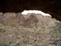
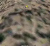
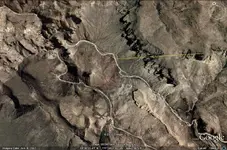
Awhile back,I had posted this google earth view of the triangle.
From a point just above this feature,you can look down at a mound of rubble in the canyon below.
The mound does not look like a heart,though.But then again,the heart stone insert doesn't tell you to look for a "heart" from the triangle.Instead,it shows an "omega" symbol.Beyond that mound can be seen a mountain with four distinct peaks.In exactly the opposite direction,another feature of the heart insert can be seen.
SH.
Attachments

somehiker
Silver Member
- Joined
- May 1, 2007
- Messages
- 4,365
- Reaction score
- 6,435
- Golden Thread
- 0
- Primary Interest:
- All Treasure Hunting
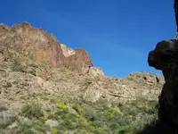
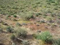
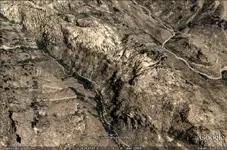
For comparison sake,here is a photo of the triangle,taken from slightly above.It measures 80'x80'x80'
Note the fallen wall of rock that crosses one side.That particular line of rock points directly to the mound.The Bilbrey map cross has a triangle with a line across one side as well.
The triangle area is leveled and edged with rock as well.Fairly overgrown now though.
SH.
Note the fallen wall of rock that crosses one side.That particular line of rock points directly to the mound.The Bilbrey map cross has a triangle with a line across one side as well.
The triangle area is leveled and edged with rock as well.Fairly overgrown now though.
SH.
Attachments
Quinan Bear
Sr. Member
- #108
Thread Owner
Thanks for the info Somehiker;
Those pics and your explanation was great knowledge for me to obtain, thanks....
That last picture doesn't look like the same area as the article in the paper, that shows the priest horse and heart?
Know that you have the vein, you can follow it to anther fault or conjuncture of rocks to where you will find minerals as well.
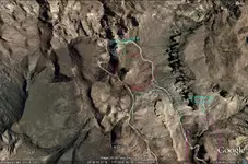
This is what I am currently working on, to find the mines from those stone maps. I use the maps for a general location of the area and then i search my data to follow the veins, rocks and faults. Since stage three of the map is to find the markers on rocks that are near the mine, I can't see them from my view. So i use the geology maps (among others) to pin point a mine. I have added a google pic of a prime location. these rock types are circled by different colors, You would need to see these personally to see the different rocks.
Those pics and your explanation was great knowledge for me to obtain, thanks....
That last picture doesn't look like the same area as the article in the paper, that shows the priest horse and heart?
Know that you have the vein, you can follow it to anther fault or conjuncture of rocks to where you will find minerals as well.
This is what I am currently working on, to find the mines from those stone maps. I use the maps for a general location of the area and then i search my data to follow the veins, rocks and faults. Since stage three of the map is to find the markers on rocks that are near the mine, I can't see them from my view. So i use the geology maps (among others) to pin point a mine. I have added a google pic of a prime location. these rock types are circled by different colors, You would need to see these personally to see the different rocks.
Attachments
Quinan Bear
Sr. Member
- #109
Thread Owner
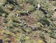
This picture looks like the heart with a cross in the center, like the one on the priest stone.somehiker said:Another ring of rocks,undoubtedly manmade and indicated on the stone maps.
SH.
Real de Tayopa Tropical Tramp
Gold Member
- Joined
- Nov 8, 2004
- Messages
- 14,582
- Reaction score
- 11,947
- Golden Thread
- 0
- Location
- Alamos,Sonora,Mexico
- Primary Interest:
- All Treasure Hunting
Good morning David: On your shaft location, I can't find any trace of any tailing
Don Jose de La Mancha
Don Jose de La Mancha
Quinan Bear
Sr. Member
- #111
Thread Owner
It's there in that area, I found it on a geological survey that states that there is a shaft theere. and there is another type mine if you head south up the western canyon and turn right at first turn (near second water hole i believe) you will find an Indian mine that is also marked on the geological map. Look at the fault line just above the "Lemonade stand" on top of the cliff to the west is the fault. Follow that west in the angle it is heading. from that fault line you can see others that intersect it.Real de Tayopa said:Good morning David: On your shaft location, I can't find any trace of any tailing
Don Jose de La Mancha
I can't show you everything that I use for my research but i assure you that there is a shaft there, I can't see them putting false information down.
Attachments
somehiker
Silver Member
- Joined
- May 1, 2007
- Messages
- 4,365
- Reaction score
- 6,435
- Golden Thread
- 0
- Primary Interest:
- All Treasure Hunting
"That last picture doesn't look like the same area as the article in the paper, that shows the priest horse and heart?"
No it is not the same area.I have been concentrating my efforts in a different area that my own research and older trails have led me to.
"This picture looks like the heart with a cross in the center, like the one on the priest stone."
The heart on the Priest map has a number 4 in it.It is the rectangle that has the cross and likely represents the map stone with the cross on the back face.It may be that this also indicates where the map stones would have been found if they had reached the cache location intended by the maker of the maps.When I climbed up to that location on the priest,there was nothing there to indicate alteration of the natural landscape.
Regards:SH
Quinan Bear
Sr. Member
- #113
Thread Owner
Oh!?!
I thought you were showing me the stone markers and where they lead to. I myself am doing them same as you but in a different way. You follow trails and I follow rocks. As i stated before, if you don't find any minerals in the old mines because they got taped out, then you can follow the vein to the next junction point and find more, this is what I do to find veins that are not known to others around here in my home town.
I admit. I don't have a conventional way of searching for mines as you guys do, BUT that don't mean that my information and knowledge is not good to know. Like pictures that Tayopa put up on the mine. He asked my opinion on what i thought and i was very close and that was without knowing the area at all.
If you would like to hear my thoughts on something you might have questions on, I would be glad to help. Privately that is. what is told and revealed to me in confidence will remain that way. Just thought I would mention that just in case you wanted to have a second set of eyes or another way of seeing something, perhaps together i can help you. No worries if you don't want to do that, I just thought you should know.....
Here is a pic of a great view of a Junction point and how the rocks are changed from directions and I would guess that there should be a mineral vein in that area..
Attachments
somehiker
Silver Member
- Joined
- May 1, 2007
- Messages
- 4,365
- Reaction score
- 6,435
- Golden Thread
- 0
- Primary Interest:
- All Treasure Hunting
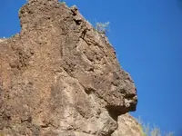
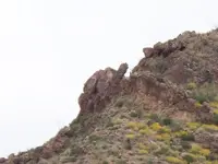
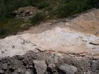
I do not believe that the Stone maps were created to lead to any mines at all.My understanding is that they were intended to assist Jesuits or their representatives to locate and recover the accumulated results of three hundred years of Jesuit efforts to amass wealth in the region.The location that they chose is perfect for several reasons,but the mines that they may have worked(with a couple of exceptions) are a short distance away.The directions that one must go,to reach these mines and related facilities,are indicated on the Latin heart and to a simpler degree,the Perficio map.There are several kinds of "markers",it seems,along the extended trail.They vary from small flat red stones with holes and V's along the most difficult trail to the mound,to large single boulders that have been coated in a white stucco-type material,visible at the beginning and end of the far easier to negotiate trail that would be best for horses and mules.The rock rings seem to be for visual reference only and are all located on steep slopes some distance from the trails.
Here is a photo of the first whitened boulder.There is a small cross carved in the rockface nearby as well.
SH.
Here is a photo of the first whitened boulder.There is a small cross carved in the rockface nearby as well.
SH.
Attachments
Quinan Bear
Sr. Member
- #117
Thread Owner
I see the white rocks and can understand your view and would agree to what you say as i can't say different from not being there. You may be on to something. Nice pics thanks.
Here is the pic of the cresent moon, triangle and circle. I would think that you know where this place is? I croped it to hide the area around it some.
Here is the pic of the cresent moon, triangle and circle. I would think that you know where this place is? I croped it to hide the area around it some.
Attachments
somehiker
Silver Member
- Joined
- May 1, 2007
- Messages
- 4,365
- Reaction score
- 6,435
- Golden Thread
- 0
- Primary Interest:
- All Treasure Hunting
I haven't got the slightest idea where that is.As with the comparison that I gave as an example,the view that you get when actually there is usually far different than that given by google earth.Usually the object is not recognizable ,or has been distorted so much by GE that it is not what you expected at all.Even the terrain you planned to explore can be far more rugged,even impassable when actually there.I mainly use it when I want to see what something would look like from far above or far away.After all,that is where the GE images came from.Not one mine or cave that I have found in the mountains can I find on GE.And some caves are big enough to drive a truck into.Thats just the way it is.
Regards:SH
Regards:SH
Cubfan64
Silver Member
- Joined
- Feb 13, 2006
- Messages
- 3,001
- Reaction score
- 2,858
- Golden Thread
- 0
- Location
- New Hampshire - USA
- Detector(s) used
- Fisher CZ21, Teknetics T2 & Minelab Sovereign GT
- Primary Interest:
- All Treasure Hunting
Great photos Somehiker! I'll have to see what happens this fall as I haven't heard whether the Rendezvous is "on" again or not. I think even if it's not, I'm going to convince my wife to join me on an October trip out there just so she can see the area and hopefully become as spellbound by it as I've been ")
I'd love to go exploring with you for a day or two, but not sure yet if my wife would be up for it physically, and I don't want to leave her behind when we're on a "vacation."
Let's stay in touch though and maybe we can work something out. You seem to have found some interesting things again.
I'd love to go exploring with you for a day or two, but not sure yet if my wife would be up for it physically, and I don't want to leave her behind when we're on a "vacation."
Let's stay in touch though and maybe we can work something out. You seem to have found some interesting things again.
Quinan Bear
Sr. Member
- #120
Thread Owner
I understand all that.
My view is only good at a high level, but it is still quite good for seeing the "big" picture, things like the fault lines, cracks, ranges, valleys. Rocks the size of cars are seen well and the shadows of them give you an idea of hieght and the curser will show you the same when you pan over it. The only thing i can't see are the sides of sheer cliffs and holes in them or under overhangs. This is where the photos that I recieve come in handy. I can get an even better idea by looking at geology and magnetic maps and compare them together. I think i could come quite close in this way of seeing things from afar. If i had someone that would like to join forces, then perhaps more things about the Superstitions might be known. I am sure that the Government has a better idea of what is really there then we think they do. I have noticed that many of the geology maps of that area, don't show anything in those areas. There are many places on google, where you can zoom in and see the ground close up and others that are out in the middle of no-wheres and only allow you to zoom in so much.
There are some "Facilities" that are allowed to have a few minutes with the satelite and are able to zoom in and read a newspaper. If they have images of the whole world, then why not show what it looks like up close? minus the private areas and such, but not for public lands or forest that belongs to the people as a whole.
Top Member Reactions
-
 2319
2319 -
 1424
1424 -
 1349
1349 -
 1325
1325 -
 1111
1111 -
 970
970 -
 848
848 -
 831
831 -
 706
706 -
 596
596 -
 564
564 -
 558
558 -
 510
510 -
 465
465 -
 464
464
Similar threads
- Replies
- 54
- Views
- 4K
Users who are viewing this thread
Total: 1 (members: 0, guests: 1)
