I was wondering if you had thought of going to the courthouse and looking up who had owned this property in the past and researched if they may have had any connection with the confederacy, or the KGC. Also Shortstack, I know what you mean about Oklahoma, I grew up on a ranch on the rim of Palo Duro Canyon, and my mom lives in Lone Wolf Oklahoma now. I live in the mountains of Colorado and we don't have snow storms like in the planes. You have about a dozen calm days a year when you can throw a Frisbee over there.
You are using an out of date browser. It may not display this or other websites correctly.
You should upgrade or use an alternative browser.
You should upgrade or use an alternative browser.
Does this mean anything?
- Thread starter Charmin
- Start date
Shortstack
Silver Member
- Joined
- Jan 22, 2007
- Messages
- 4,305
- Reaction score
- 419
- Golden Thread
- 0
- Detector(s) used
- Tesoro Bandido II and DeLeon. also a Detector Pro Headhunter Diver, and a Garrett BFO called The Hunter & a Garrett Ace 250.
- Primary Interest:
- All Treasure Hunting
Radigast said:I was wondering if you had thought of going to the courthouse and looking up who had owned this property in the past and researched if they may have had any connection with the confederacy, or the KGC. Also Shortstack, I know what you mean about Oklahoma, I grew up on a ranch on the rim of Palo Duro Canyon, and my mom lives in Lone Wolf Oklahoma now. I live in the mountains of Colorado and we don't have snow storms like in the planes. You have about a dozen calm days a year when you can throw a Frisbee over there.
LOL, yep. The cowboys have to use Polident to keep their hats on.

kenley
Hero Member
- Joined
- Nov 2, 2008
- Messages
- 547
- Reaction score
- 7
- Golden Thread
- 0
- Location
- Seminole County, Ok.
- Detector(s) used
- GTI 2500
- Primary Interest:
- Metal Detecting
Sandcreek..Go to Google earth and locate your site. Click on the analog clock in the center of the bar and a slider will pop up. you can go back and see what the property looked like back to when they started using satalite images.
I am trying to find one for aerial photography. County agent at the court house?
I am trying to find one for aerial photography. County agent at the court house?
Charmin
Bronze Member
- #44
Thread Owner
Yes, we are checking into that right now---have just acquired a map that shows the original land ownersRadigast said:I was wondering if you had thought of going to the courthouse and looking up who had owned this property in the past and researched if they may have had any connection with the confederacy, or the KGC.
 .
. Thanks Radigast!!
Charmin
Bronze Member
- #45
Thread Owner
Cool Kenley--I didn't know you could do that with Google earth.....I'll try that and see what it brings up. Thanks so muchkenley said:Sandcreek..Go to Google earth and locate your site. Click on the analog clock in the center of the bar and a slider will pop up. you can go back and see what the property looked like back to when they started using satalite images.
I am trying to find one for aerial photography. County agent at the court house?
 .
.Old Dog
Gold Member
Gertie,
A chevron looks like a Sergent's stripe.
The three bent lines on the sleve of a military Sergent's sleeve are chevrons.
A chevron looks like a Sergent's stripe.
The three bent lines on the sleve of a military Sergent's sleeve are chevrons.
Shortstack
Silver Member
- Joined
- Jan 22, 2007
- Messages
- 4,305
- Reaction score
- 419
- Golden Thread
- 0
- Detector(s) used
- Tesoro Bandido II and DeLeon. also a Detector Pro Headhunter Diver, and a Garrett BFO called The Hunter & a Garrett Ace 250.
- Primary Interest:
- All Treasure Hunting
Yep, Gertie. What Thom said.
Each stripe is a chevron. Some are peaked high in the center and other styles are cupped in the center. Example: U.S. Army and Marines have stripe peaked in the center while the basic U.S. Air Force stripe is cupped in the center. Some countries such as Canada and Britain military have chevrons that are sharp peaked DOWNWARD. In the field, you might run into any of those shapes used a slash markers.
Each stripe is a chevron. Some are peaked high in the center and other styles are cupped in the center. Example: U.S. Army and Marines have stripe peaked in the center while the basic U.S. Air Force stripe is cupped in the center. Some countries such as Canada and Britain military have chevrons that are sharp peaked DOWNWARD. In the field, you might run into any of those shapes used a slash markers.
naturegirl
Bronze Member
The time line on google Earth is neat, we use it alot. You can see a lot of difference, high water, winter's lack of vegetation, ect.
Charmin
Bronze Member
- #50
Thread Owner
Yes, it is really neat---I haven't played around with the Google earth thing too much, but am going to now! (Shortstack said the Bing maps thing is really good to use too.)naturegirl said:The time line on google Earth is neat, we use it alot. You can see a lot of difference, high water, winter's lack of vegetation, ect.
Thanks Gertie!gertie said:Cool site Sandcreek4.............Gertie
Shortstack
Silver Member
- Joined
- Jan 22, 2007
- Messages
- 4,305
- Reaction score
- 419
- Golden Thread
- 0
- Detector(s) used
- Tesoro Bandido II and DeLeon. also a Detector Pro Headhunter Diver, and a Garrett BFO called The Hunter & a Garrett Ace 250.
- Primary Interest:
- All Treasure Hunting
There's 2 really good points in favor of bing maps. You go to the site and use it THERE without having to download any applications like Google Earth requires and bing maps has what they call "Birds Eye View" which is fantastic if it is available in the area you are interested in. The BEV is not available in all areas.
The website is: http://www.bing.com/maps/
The website is: http://www.bing.com/maps/
hucklburry
Jr. Member
kenley said:My two cents...The symble was done by someone with time on their hands and a pointed piece of iron or steel.
My first thought was a young boy dreaming of his own ranch in the Osage Hills and drawing up a brand, or copying one he had seen.
As old as the chevrons are, they were probably made fifty plus years ago and close to the ground. Windmill guy line?
The loop in the tree limb is more recent 15-20 years
I was born in Pawhuska, love the rolling hills and mesas.
Good luck with your puzzle.
Kenley, Trees grow at the top, not from the base, so the chevrons are at the same height as they always were.
OD and SS, thank you for the information,,,,very useful.
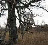
Sandcreek4, I can't help but notice, but in the base of the tree in the pic attached, I put an arrow where there seems to be something. It may or maynot be anything, but might be worth checking out next time your there......good luck Gertie
Sandcreek4, I can't help but notice, but in the base of the tree in the pic attached, I put an arrow where there seems to be something. It may or maynot be anything, but might be worth checking out next time your there......good luck Gertie
Attachments
Charmin
Bronze Member
- #54
Thread Owner
Gertie---we've found two or three trees that have the bark missing at the bottom like that. I don't know if that something natural---will lightning cause that if it hits the ground near a tree? or is that something manmade? I'll sure take another look at it when we go back to this place, and thanks for pointing it out!gertie said:OD and SS, thank you for the information,,,,very useful.
Sandcreek4, I can't help but notice, but in the base of the tree in the pic attached, I put an arrow where there seems to be something. It may or maynot be anything, but might be worth checking out next time your there......good luck Gertie
Sandcreek4, it was not uncommon for the kgc/outlaws to strip the bark of the tree or blaze it, and then carve in the stripped area. In the picture with the arrow, it looks like there may be something carved in the area where the bark is gone. It is hard to tell, because of the piece of grass that is in front of it or it could just be the angle of the picture. It may be nothing, but I think warrants a second look....Have fun hunting....Gertie
Charmin
Bronze Member
- #56
Thread Owner
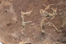
Found some things of interest(at least to us). The first is a rock with the initials/letters carved into it. Are these just actual initials or do you all think they mean something else?
Looks like F-R ?
This F-R rock rests on the side of a hill---perfect view of the whole valley below.
Maybe a person/watcher/lookout sat there and scratched his initials into this rock? But why the (-) dash between the initials? instead of a (.) dot?
Looks like F-R ?
This F-R rock rests on the side of a hill---perfect view of the whole valley below.
Maybe a person/watcher/lookout sat there and scratched his initials into this rock? But why the (-) dash between the initials? instead of a (.) dot?
Attachments

RockHopper2
Full Member
Question, is the second pic 26 ft or paces to the right of the F-R rock? Rocky
Charmin
Bronze Member
- #59
Thread Owner
It was actually to the right, but I can't remember how many paces. (I forgot to take my notebook with me to write it downRockHopper2 said:Question, is the second pic 26 ft or paces to the right of the F-R rock? Rocky
 --chaulk that up to being a newbie
  !) You think maybe this was a direction rock? and not just someones initials?
To the left of the F-R rock, I found a metal object buried(horseshoe) with the open end pointing us back towards our rock monument and the creek bottom below.
Thanks Rocky!
RockHopper2
Full Member
SC4, the F can stand for final mark, the dash is direction to the right, because it is to the right of the F. The R is a distance of 21, unless the leg is not connected to the R on purpose, =42. When there is a gap in letters you double the value of the letter, sometimes. Now if there is a patron saint close to the F-R rock, change everything I just said to bible verses. Rocky
Similar threads
- Replies
- 8
- Views
- 694
- Replies
- 13
- Views
- 1K
Users who are viewing this thread
Total: 1 (members: 0, guests: 1)
