Filing a claim.

ProspectorALEX

Sr. Member
Apr 14, 2013
292
184
Clam Gulch, AK
Detector(s) used
Whites GMT E-series
Primary Interest:
Prospecting
So, my dad and I are finally ready to stake a couple placer claims. However, I have found different requirements from the state and federal levels. If the claim is on FS land, do you still have to follow state policy for marking the claim posts? Secondly, I have read that you should file claims based on the Township, range, section and quarter-section if possible, but the claims we want to make wouldn't be efficient if we were to stake them that way because the creek isn't a north-south or east-west flowing creek. So, is there another way to stake the claim without using that system? I have been reading other threads on staking claims, but I haven't found any way to stake claims without using township, range, etc. Thankyou for any help! Also, there are several claims in the area that are diagonal on the creek, I just don't know how to file so they could be like them.
 

Last edited:
Upvote 0

Underburden

Sr. Member
Mar 22, 2012
484
1,125
Idaho
Detector(s) used
Gold Hog Stream Sluice
Primary Interest:
Prospecting
Did I see you use the word efficient when describing a gov't requirement?
Good one Alex8-)
 

OP
OP
ProspectorALEX

ProspectorALEX

Sr. Member
Apr 14, 2013
292
184
Clam Gulch, AK
Detector(s) used
Whites GMT E-series
Primary Interest:
Prospecting
Did I see you use the word efficient when describing a gov't requirement?
Good one Alex8-)

Yeah, if we were to stake with those requirements, it would take 4-6 claims instead of 2 to cover the area we want. I also know that the govt. never seems to be efficient. I have been taking government classes lately, and that has become evident.
 

Last edited:
OP
OP
ProspectorALEX

ProspectorALEX

Sr. Member
Apr 14, 2013
292
184
Clam Gulch, AK
Detector(s) used
Whites GMT E-series
Primary Interest:
Prospecting
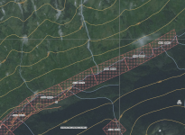
Capture.PNG Here is an example of what I mean. these claims aren't conforming to the system, and I am wondering how to file a claim like these. Is this where metes and bounds comes in and if so, how do you properly use that method?
 

Clay Diggins

Silver Member
Nov 14, 2010
4,885
14,258
The Great Southwest
Primary Interest:
Prospecting
Congratulations on finding a deposit Alex. I'll try to give you the efficient version. :laughing7:

Placer claims should be located by the aliquot parts of the PLSS. That means you need to follow the north/south east/west trend of the Public Land Survey. If you had discovered a lode deposit you could follow the direction of the strike but with placers you are going to have to describe your claim by the regular portions of the survey. That's all in the Mining Act of 1872.

That does not mean you have to follow the lines of the survey it means you make your claim based on the regular divisions (aliquots) of the survey. For instance if you were making a 20 acre claim you could describe it as the south half of a quarter quarter section (NWNW or SESW etc). That would make the claim 1320 feet on the east/west and 660 feet on the north/south dimensions (20 acres). Describing the claim as the west half of a quarter quarter would put the 1320 foot long dimension on the north/south and the 660 foot short dimension on the east/west.

As I said you don't have to follow the lines themselves but the smallest division of the survey you can describe the claim by would be the quarter quarter quarter or 10 acres. Since placer claim descriptions can not join on a corner on your 20 acre claim that would mean you could move 10 acres (1/2) of the claim or the whole claim off the quarter quarter line east/west or north/south by 330 feet.

Now I know you are thinking why not just stack those regular portions so they follow the creek? There is a limit to the maximum long dimension of a 2 person 40 acre claim. That limit is 1320 feet - the same as a 20 acre claim. It's the policy of the United States to prevent claims that break the mineral estate into long strips. If you really want to follow that creek you will need to file however many 20 acre claims it takes to cover your deposit with the claims following the PLSS grid and being offset by increments of 330 feet.

Ah! Now you are thinking it might just be easier to make a lode claim so you can follow that creek without making a boatload of placer claims. That's a no go unless you discovered a mineral in place - a hardrock vein or ledge. A lode claim legally can't be located where there is no lode.

Are you confused yet? Luckily there is a source to help you straighten this out with some diagrams etc. Nevada (the Silver State) is serious about encouraging mining so they put out a booklet to help you visualize these claim restrictions as well as a bunch of other stuff you probably haven't even thought of yet. Of course Land Matters has a good copy for free in their Library. Mining Claim Procedures is just 58 pages long but it's the best resource from any state. Study that and I'm sure my convoluted explanation will make perfect(?) sense.

About those state location requirements... Congress described the basic requirements for a mining claim location to make it valid under federal law. Then they left it up to the states and the miners to refine those requirements to meet their needs. (It's all there in the 1872 Mining Act)

The states and the miners are allowed to make any additional regulations about mining claims as long as they don't step on the federal regulations. So the states set the actual procedures needed to make a location. That often includes things like the type of monuments, what has to be on a location notice, where the location notice is recorded and what the cost is, and deadlines for recording your public mining notices and performing labor. If an organized mining district exists they are allowed to make even more regulations as long as they don't contradict the State or Federal regulations. This is the basis of American government hierarchy and you will find the same thing when dealing with water rights, land rights and many other aspects of substance in law.

Often this means claims are staked, monumented and recorded differently from state to state. The reason it matters if you follow the state regulations for mining claims is because if you have a mining contract, lease, association or mineral rights dispute it's going to be settled in a state court regulated by state laws. If you don't already have your state required ducks in a row (location requirements) you won't have a solid basis for legally protecting your claim to the minerals.

A lot of people are saying to themselves right now - hey! mining claims are a grant from Congress, not some state stuff so your mineral rights should be in a federal court under federal law.

You would think that would be the case except in the very first federal mining law Congress said - not our problem, and ducked out of the whole thing leaving it up to the miners and the states to settle things their own way within a pretty tight requirement. Here's that first 1865 mining law in it's entirety:
That no possessory action between individuals in any of the courts of the United States for the recovery of any mining title, or for damages to any such title, shall be affected by the fact that the paramount title to the land on which such mines are, is in the United States, but each case shall be adjudged by the law of possession.

To "possess" your claim you must follow the laws of location - all of them including and especially the State laws. Otherwise how would a state court rule for possession in your favor?

Read the two documents linked here along with your state's location laws and I'm sure with a little study you will answer your questions. If not just wander back to this thread and ask any questions that come up. :thumbsup:

Heavy Pans
 

OP
OP
ProspectorALEX

ProspectorALEX

Sr. Member
Apr 14, 2013
292
184
Clam Gulch, AK
Detector(s) used
Whites GMT E-series
Primary Interest:
Prospecting
To quote the guide posted, " As nearly as practical, a placer claim must conform to the system of public land surveys, which means it should conform to the boundaries of a section and take a legal subdivision (aliquot part) of the section. This conformity may not be possible if the area is unsurveyed, if there are preexisting claims, or if the claim follows the bed of a meandering stream." So, since the stream is meandering, what is the other way for us to locate the claims? Another guide I found that was quoting the blm guide said " If the claim cannot be described by aliquot part (if the land is unsurveyed), the claimant must provide a metes-and-bounds description that fixes the position of the claim corners with respect to a specified claim corner, discovery monument, or official survey monument." The area that we are location is not surveyed, so could we use the NE claimpost as our specified claim corner?
 

Last edited:

Clay Diggins

Silver Member
Nov 14, 2010
4,885
14,258
The Great Southwest
Primary Interest:
Prospecting
If the land is open to location it doesn't matter whether it's Forest Service or BLM administered. The surface management agency does not determine location law - the state does.

I think it's important to understand that the Forest Service does not regulate mining. The Forest Service and the BLM have a legal duty to protect the surface resources they manage from undue or unnecessary degradation of those resources. Interestingly the State statutes I linked you to describe what undue or unnecessary degradation means in relation to the miner.
surface disturbance greater than would normally result when an activity is being accomplished by a prudent operator in usual, customary, and proficient operations of similar character and considering site specific conditions
Not surprisingly that echos what the Supreme Court ruled in Utah v. Andrus.
a reasonable interpretation of the word 'unnecessary' is that which is not necessary for mining.
'Undue' is that which is excessive, improper, immoderate or unwarranted.
And that is about the extent of the Forest Service's control of the mining process. Notice there is nothing in there that would empower the surface management agencies to determine the proper procedure for locating a mining claim.

Heavy Pans
 

OP
OP
ProspectorALEX

ProspectorALEX

Sr. Member
Apr 14, 2013
292
184
Clam Gulch, AK
Detector(s) used
Whites GMT E-series
Primary Interest:
Prospecting
If the land is open to location it doesn't matter whether it's Forest Service or BLM administered. The surface management agency does not determine location law - the state does.

I think it's important to understand that the Forest Service does not regulate mining. The Forest Service and the BLM have a legal duty to protect the surface resources they manage from undue or unnecessary degradation of those resources. Interestingly the State statutes I linked you to describe what undue or unnecessary degradation means in relation to the miner.

Not surprisingly that echos what the Supreme Court ruled in Utah v. Andrus.

And that is about the extent of the Forest Service's control of the mining process. Notice there is nothing in there that would empower the surface management agencies to determine the proper procedure for locating a mining claim.

Heavy Pans

"a description of the claim with such reference to some natural object or permanent monument so that an intelligent person with a knowledge of the prominent natural objects and permanent monuments in the vicinity can identify the claim." Woud the creek count as a natural, permanent object or is this referring to a peak, rock outcrop, boulder patch or some other type of "natural object or permanent monument"
 

Underburden

Sr. Member
Mar 22, 2012
484
1,125
Idaho
Detector(s) used
Gold Hog Stream Sluice
Primary Interest:
Prospecting
"an intelligent person with a knowledge of the prominent natural objects and permanent monuments in the vicinity"
Who would that be...not someone who doesn't live near the proposed claim. I usually leave that section blank along with naming any adjacent claims.
 

Top Member Reactions

Users who are viewing this thread

Top