signal
Hero Member
- Apr 30, 2011
- 582
- 428
- Detector(s) used
- Minelab CTX-3030, Minelab Exalibur II, Garrett AT Pro
- Primary Interest:
- Beach & Shallow Water Hunting
I was wondering if anyone had any information on Fort Van Swearingen and its location? I have the location from the book Forts, Camps and Batteries of Florida, which puts it at 27 14'N 80 '40W. I have also read where some believe it to be on either side of whats known as Van Swearingen Creek, which is at 27°13'12.00"N 80°38'30.97"W. On Google Earth it hardly looks like a creek these days however. I have also seen some say its near 27 12'36N 80 34'49W.
In the following publication:
[Letter]
Edward T. Keenan
The Florida Historical Quarterly , Vol. 39, No. 3 (Jan., 1961), pp. 298-302
Published by: Florida Historical Society
Article Stable URL: JSTOR: An Error Occurred Setting Your User Cookie
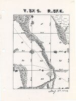
It mentions that its location is at Sec. 33, T-37-S, R-37-E, which I have to believe is some sort of Plat description, does anyone know how to convert this to GPS? Also the article says the following about the location:
"The post was in St. Lucie County. To reach the site today one may take a country road leading east from the Sherman R.R. Station, a few miles S.E. of Okeechobee, go about eight miles until one comes to a bridge. The fort was just across the bridge: Sec. 33, T-37-S, R-37-E"
So a few things. First those directions written in 1961 assume someone knows the location of the old Seaboard Air Line station called Sherman. I can find no information on this, no gps coordinates, and I am not sure if it exists still. I have located the rail line going through Indiantown, but not sure if its the same as may have existed in 1961. If anyone has any information on the Sherman RR Station in Indiantown please let me know. Without knowing the location of Sherman or being able to understand those plat coordinates, I am at a loss.
In the following publication:
[Letter]
Edward T. Keenan
The Florida Historical Quarterly , Vol. 39, No. 3 (Jan., 1961), pp. 298-302
Published by: Florida Historical Society
Article Stable URL: JSTOR: An Error Occurred Setting Your User Cookie
It mentions that its location is at Sec. 33, T-37-S, R-37-E, which I have to believe is some sort of Plat description, does anyone know how to convert this to GPS? Also the article says the following about the location:
"The post was in St. Lucie County. To reach the site today one may take a country road leading east from the Sherman R.R. Station, a few miles S.E. of Okeechobee, go about eight miles until one comes to a bridge. The fort was just across the bridge: Sec. 33, T-37-S, R-37-E"
So a few things. First those directions written in 1961 assume someone knows the location of the old Seaboard Air Line station called Sherman. I can find no information on this, no gps coordinates, and I am not sure if it exists still. I have located the rail line going through Indiantown, but not sure if its the same as may have existed in 1961. If anyone has any information on the Sherman RR Station in Indiantown please let me know. Without knowing the location of Sherman or being able to understand those plat coordinates, I am at a loss.


")