HOOT OWL TREE?

reptwar1

Sr. Member
Jan 24, 2013
440
287
Russelville Arkansas
Primary Interest:
All Treasure Hunting
OP
OP
reptwar1

reptwar1

Sr. Member
Jan 24, 2013
440
287
Russelville Arkansas
Primary Interest:
All Treasure Hunting
Hoot OWL TREE?
 

Attachments

  • 1490743920605.jpg
    1490743920605.jpg
    172.1 KB · Views: 451

miboje

Hero Member
Mar 21, 2016
780
789
Detector(s) used
Garrett GTA 1000 PowerMaster
Primary Interest:
All Treasure Hunting
Is it old enough to have been done by Native American people?

Sent from my SAMSUNG-SM-N900A using Tapatalk
 

OP
OP
reptwar1

reptwar1

Sr. Member
Jan 24, 2013
440
287
Russelville Arkansas
Primary Interest:
All Treasure Hunting
Not that I could tell. And I was wondering the same about the age. Doesn't really look that old to me
 

Rebel - KGC

Gold Member
Jun 15, 2007
21,680
14,739
Any "hold-down" Sinew Scars...? Sinew (dried blood vessels from Deer) was used to "hold down" the branches of young saplings, "breaking" as tree got older/stronger into the right angle shape. the "elbow" of the tree became the NOSE, as if "sniffing" for GOLD/Water/direction... WHATEVER. The NOSE, KNOWS! LOL! :icon_thumleft:
 

Last edited:

Ditlihi

Banned
Aug 20, 2016
1,227
4,793
Primary Interest:
All Treasure Hunting
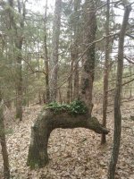
This tree is in Dardanelle Arkansas very close to the Arkansas river. It points away from the river, further inland toward a cave system that I found a couple years back, but haven't been able to relocate. Area was occupied by native Americans, not to mention civil war action. Thoughts? Indians? KGC?


If this tree is on the bank of the Arkansas River, and points northward, it very likely may have been made by the Cherokee to mark their land boundary resulting from the Council Oaks Treaty of 1823. That "treaty", or should I say Mandate by acting Arkansas Governor Robert Crittenden, resulted in the removal of Arkansas Cherokees from all land south of the Arkansas River. From your photograph, the tree looks to be of an age that would fit that time period.

Treaty of Council Oaks - Encyclopedia of Arkansas
 

OP
OP
reptwar1

reptwar1

Sr. Member
Jan 24, 2013
440
287
Russelville Arkansas
Primary Interest:
All Treasure Hunting
If this tree is on the bank of the Arkansas River, and points northward, it very likely may have been made by the Cherokee to mark their land boundary resulting from the Council Oaks Treaty of 1823. That "treaty", or should I say Mandate by acting Arkansas Governor Robert Crittenden, resulted in the removal of Arkansas Cherokees from all land south of the Arkansas River. From your photograph, the tree looks to be of an age that would fit that time period.

Treaty of Council Oaks - Encyclopedia of Arkansas

Actually, it's on the south bank of the river, and pointing South as well. The 400/500 yr old tree that hosted the " treaty" or robbery of council oaks still stands about a mile downstream of the marker tree and caves. The tree is an awesome sight. Huge!!!!
 

Ditlihi

Banned
Aug 20, 2016
1,227
4,793
Primary Interest:
All Treasure Hunting
Actually, it's on the south bank of the river, and pointing South as well. The 400/500 yr old tree that hosted the " treaty" or robbery of council oaks still stands about a mile downstream of the marker tree and caves. The tree is an awesome sight. Huge!!!!


Robbery indeed! :icon_thumright:
 

orangeman

Hero Member
Jan 15, 2014
792
1,394
I can take you to no telling how many of these trees. I live in searcy county and see bent trees all the way to Russellville off the highway. There so many of these trees it's mind boggling. This tree was on bear creek there's is a spring that comes out right under it. So it would appear that's what's it marked. Then you go the way it's pointing and find a rock with a small drill hole. Go a bit farther and find a large head stone looking rock.
 

orangeman

Hero Member
Jan 15, 2014
792
1,394
The ones I see off the highway are some most I have found in a few square mile area of woods. Along a good size stream.
 

franklin

Gold Member
Jun 1, 2012
5,036
7,168
Detector(s) used
Garrett ADS-7X, Fisher Two Box M-Scope, Mother Lode Locator, Dowsing Model 20 Electroscope, White's TM808, White's TM900, Inground Scanners
Primary Interest:
All Treasure Hunting

franklin

Gold Member
Jun 1, 2012
5,036
7,168
Detector(s) used
Garrett ADS-7X, Fisher Two Box M-Scope, Mother Lode Locator, Dowsing Model 20 Electroscope, White's TM808, White's TM900, Inground Scanners
Primary Interest:
All Treasure Hunting
A lot of those trees like that are caused by deer eating the main shaft of the tree and leaving a limb. For the tree to survive all it's growth goes to the limb. Then the tree can either brake off and another limb grows straight up off of that. I know where plenty trees are like that and they have nothing to do with trail markers or anything to do with marking a treasure.

Now if the trees are bent that way and there are more than one then you may have a treasure nearby. But you can see the main shaft of that tree broke off or eat off by deer as you can see the grain of the bark runs up then goes horizonal. I say it is just a normal deformed tree by nature or work of the elements or even deer.
 

Top Member Reactions

Users who are viewing this thread

Top