How do you find old maps? Please help!

Hmm...check plat map books in a genealogical society for the county you are in or whatever county you desire. Good for finding trolly and R.R. routes, farms, churches and schools, graveyards etc. Sorry if I repeat anyone. Have you checked the site called "Historic Aerials"? GL & HH
 

I just want general. I would like maps that would tell me where old houses used to be. Like a old property map.

Hi Smf. To find where old houses used to be you have to look at an old map and compare it to a new map. If the house is not on the new map then you have found where an old house used to be. Topo maps are good for this because they show homes and structures as black squares on the map. I like to hunt cellar holes in the woods. All that is left of the house is the foundation (cellar hole). To locate one I'll look at an old topo map of places that I know are wooded and no current homes exist. Then I'll go looking for the cellar hole. The places I have found are on public land that is used for hunting. So I'm fortunate to have many public places to hunt.

The three pictures I attached show one of the best places I have ever hunted (and still hunt). In the early maps you can see the structures. But, the modern google earth image shows nothing there. Just woods. I even researched the name of the property owner (Henline) and found out he was there in the early 1800's. The old maps I used are the same ones I posted towards the top of this thread. Historical mapworks and My Topo Historical Maps.

Good Luck.
-Swartzie
 

Attachments

  • henline_a.webp
    henline_a.webp
    32.1 KB · Views: 144
  • henline_b.webp
    henline_b.webp
    34.9 KB · Views: 108
  • henline_c.webp
    henline_c.webp
    40.9 KB · Views: 117
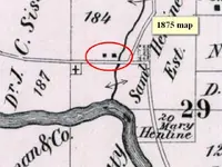
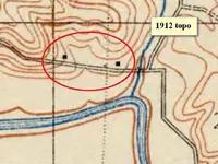
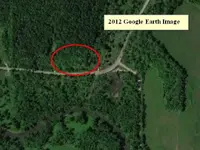
I'm no expert on NJ maps (yes, states are different due to many factors), but a useful skill to develop is to pick out the physical location of buildings, either in conjunction with maps or without.

I start by being aware of local histories, and asking myself where a house would likely be located and then looking for signs of them. In modern times, they tend to get bulldozed, but in the old days, they either burned or just settled in to the ground. They left signs like old foundations, lilac bushes, apple trees and the like. Get an eye for that. The advantage of that is that you bypass historical research and get right down to detecting. Don't get me wrong, research is great, but I stumble on old sites all the time and it's easy to just start swinging.
 

OK, I realize that there are people that give a serious answer like Don and people that make caustic comments like ticm but lets help out. To give info, you need the state and area like county or region designation like a mountain or valley. Next we need to know specificly what you are looking for.

Here's a general idea of what is in your area. There are about 350 items from treasure caches to ghost townes listed, and a map with the locations shown. in volume 6 of the US Treasure Atlas by Thomas T Terry. The atlases were all listed on T Net a while back. I don't know if they are still here.
There are 10 volumes to the atlas, but NJ is all in vol 6. You can get it on E Bay sometimes. FrankDeserata-1692.webp
 

OK, I realize that there are people that give a serious answer like Don and people that make caustic comments like ticm but lets help out. To give info, you need the state and area like county or region designation like a mountain or valley. Next we need to know specificly what you are looking for.

Here's a general idea of what is in your area. There are about 350 items from treasure caches to ghost townes listed, and a map with the locations shown. in volume 6 of the US Treasure Atlas by Thomas T Terry. The atlases were all listed on T Net a while back. I don't know if they are still here.
There are 10 volumes to the atlas, but NJ is all in vol 6. You can get it on E Bay sometimes. FrankView attachment 663088PS you can inlarge it by 2 clicks on it.
 

I get my topo maps at garage sales - I have many from NJ . Any particular town u need ? I probably have it .
 

Attachments

  • maps 001.webp
    maps 001.webp
    26.3 KB · Views: 96
  • maps 003.webp
    maps 003.webp
    26 KB · Views: 109
To those it concrens, mocking a member who is asking a question is against our rules.....Please stop....No one is required to answer a question, but if your going to answer it please do it in a polite and civil manner, not in a mocking tone....

"You may not.... Impersonate, imitate, pretend to be, or mock another member."
"Don't attack, provoke, insult, or deliberately offend anyone."
"Sniping, name calling, denegration and other generally negative or abusive actions are grounds for moderation. In extreme cases grounds for banning!"
"Keep the discussion civil, respectful and on topic. "
http://www.treasurenet.com/index.php?pageid=rules
 

I don't want anyone to make fun of me, but I treated the problem like it was me that was asking since although I deal with maps for a living, I've never had occasion to look at New Jersey.

I Googled "new jersey old maps". Honest, that's what I did. It came up with a lot of hits. Then I clicked on the "Images" tab to get a flavor of what's there. Well, I'm still looking after an hour. There's lots of hits. I just looked for what was detailed enough to portray buildings.

This looked like a particularly good site: New Jersey Historical Maps

For old buildings, Sanborn maps are hard to beat. I just so happens that Princeton University has digitized some 16,000 of them, and they're available online: Princeton University - Library digitizes collection of historic New Jersey maps

They're not downloadable, but they do have a viewer that zooms in, just what you need.

Go for it. Good luck!
 

Top Member Reactions

Users who are viewing this thread

Back
Top Bottom