Indian waybill to Swift Mines (Revisited)

EC.Mason

Hero Member
Feb 6, 2009
664
1,030
West Liberty Kentucky
Detector(s) used
Garrett AT Max
Primary Interest:
All Treasure Hunting
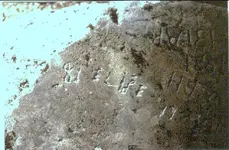
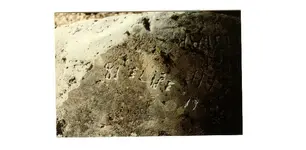
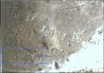
Ki, I looked in Steely's book but I cant find where he talks about ELIPE. However, he does have a picture of the same carvings that I posted a picture of that has the name ELIPE. If you find the story let me know, I would love to read it. Thanks.
-Ki- said:
Sorry guys, i remember the carving now "ELIPE"... Is that a Spanish carving? Mike Steely if i remember correctly has a great story about this carving in his book, i'll have to pull the book out and read that part again.....
 

Curtis

Hero Member
Sep 3, 2008
899
1,009
Cincinnati
Primary Interest:
All Treasure Hunting
Ki,


If you cannot find the story can you sort of paraphrase it for us. Mason and I and maybe his cousin are looking in the same area for some clues that are possible Spanish ties to the area.
 

-Ki-

Hero Member
Feb 12, 2009
642
574
EASTERN KENTUCKY
Detector(s) used
MD & Handwand "CaveHunter"Hiker" SonyDigital SLR
Well.... E.C your right there was no story, but there was a picture.. This must have been what i seen, its in page 106 of steely's book. Steely reports the carvings are spanish..... I think i remember reading about this carving somewhere other than Tnet, if i come across it i'll let you all know..... -Ki-
 

OP
OP
boomer

boomer

Sr. Member
Jul 8, 2003
487
523
kentucky
Detector(s) used
army all terrain
thanks to masons photo of the hand and with the other carvings of hands, i was able to connect the dots. we got it. there are 2 burial sites maybe 3. you need all 4 hands to find the locations and you need all 4 to find the snake. the 3rd is the snake pointing to a cliff at the head of the stream. the creek matches the snake perfect, the aerial photo shows a rockhouse or depression. maybe its where they camped? now, what to do? when to go? it needs to be dry.
 

Curtis

Hero Member
Sep 3, 2008
899
1,009
Cincinnati
Primary Interest:
All Treasure Hunting
I only knew of one set of hands, the ones you had sent about a year ago, what do you think they represent? Is there something (burials) related to them?
 

OP
OP
boomer

boomer

Sr. Member
Jul 8, 2003
487
523
kentucky
Detector(s) used
army all terrain
curtis, yes they are related to sites. whats buried? i don't know. but it has to do with the fingers of the little sandy river. each hand has its own markings on where to go to. the key is the hands carved on top of the large rock in the middle of the river, at the line of rock. whats so funny, we never new that those hands where there. we shimmed up on top to take pictures in a 360 degree sweep of the area and there they were. what ever is buried is still there. it just needs to be dry to get this done.
 

Curtis

Hero Member
Sep 3, 2008
899
1,009
Cincinnati
Primary Interest:
All Treasure Hunting
If I am not mistaken the dry season is only when the Army Corps of Engineers lets the water down for the winter pool. They will be letting it fill back soon! I was there last February (2009)and was excited to find some of the things we had talked about before. You have solved the main question I had about the natural bridge/arch.

Do you know of a natural rock bridge in Elliott or Carter Counties being 196 feet tall? Someone said it that may have fell in the 1930s?
 

OP
OP
boomer

boomer

Sr. Member
Jul 8, 2003
487
523
kentucky
Detector(s) used
army all terrain
there are 3 i knew about, i think. the 196' was at carter caves. maybe the other was big or little sinking creek. i'll look in my stuff.
 

OP
OP
boomer

boomer

Sr. Member
Jul 8, 2003
487
523
kentucky
Detector(s) used
army all terrain
ELIPE could be a last name. if that's an F instead of an E, you have Spanish name FELIPE, means lover of horses or Phillip in english. last the, Banner of arms of the King of Spain, House of Bourbon (1700-1761).
 

Curtis

Hero Member
Sep 3, 2008
899
1,009
Cincinnati
Primary Interest:
All Treasure Hunting
Boomer,
I wonder how close we are to the place where the coin molds fell out of the rocks when the lightning hit. The site of the coin molds may help a lot (I posted on another thread that a friend found some molds back in the 1970s but they were on a ledge near the line of rocks). They were tested at the UK and they were w covered with bear tallow and rapped in bearskin. This other set may be a very handy clue to start some locations from!
Mason, does anyone you know remember the discovery? Boomer posted a story about Swift or maybe a different Swift but in it the writer tells of the coin molds falling out of the cliff on the Little Sandy. He also mentions how that Swift may have traveled from the fork of the Big Sandy to the Little Sandy! This is what we (Boomer and I and others) have been looking into for over a 25 years—Boomer a lot longer. I will say once again I feel the Indian mines and Swifts are connected in that area! The Indian mentions 4 kegs of silver …so does swift. They both gave direction on travel form the Big Kanawha. They both had more than one mine(the five Indian mines are all within a 2 mile radius I have located all of them but one and thanks to boomer and Mason will locate the last one this spring/summer). The Indian tells of a lot of signs right around the line of rocks…the one rock house looks like it could have been a smelter but torn down. Boomer indicates there are things the rock map indicates.
 

Curtis

Hero Member
Sep 3, 2008
899
1,009
Cincinnati
Primary Interest:
All Treasure Hunting
Just found the pics I was going to post for Mason about ELIPE, I am sure I can find it again. Here they are. There are two that have been turned into a negative on another thread that show some of the other carvings better.
 

Attachments

  • Elipe on rock.jpg
    Elipe on rock.jpg
    53.8 KB · Views: 1,945
  • elipe reverse.jpg
    elipe reverse.jpg
    110.1 KB · Views: 2,075
  • Elipe on rock.jpg
    Elipe on rock.jpg
    53.8 KB · Views: 1,782
  • elipe upsidedown.JPG
    elipe upsidedown.JPG
    107.2 KB · Views: 1,890

-Ki-

Hero Member
Feb 12, 2009
642
574
EASTERN KENTUCKY
Detector(s) used
MD & Handwand "CaveHunter"Hiker" SonyDigital SLR
The area where lightning hit the cliff, if any ore were exposed it would be very black by now....
 

Curtis

Hero Member
Sep 3, 2008
899
1,009
Cincinnati
Primary Interest:
All Treasure Hunting
Boomer,

Did you find anything on the lightning strike and where it really was?

Any more likely treasure stuff around the Carter/Elliott/Lewis/Green up Counties? The stuff on the guy from Portsmouth newspaper was some of the best I've read on Tnet or any other site...it rang true and was very much appreciated!
 

OP
OP
boomer

boomer

Sr. Member
Jul 8, 2003
487
523
kentucky
Detector(s) used
army all terrain
below shows location of the rock that has the carvings on them. the crane was easy to figure out, head, neck, body and feet. the indian took a little longer. there is a + plus carving halfway up the side of the cliff on the side drain. someone had to go down on a rope while others held him in place to cut this, the cliff is shear, up and down. the + really stands out, cut deep. it had to be a special marker. i wonder? near the head of this small drain on top, this area is all flat land. i had an old corp of engineers aerial photo of this area and it had to have been taken when the leaves were all down. it showed what looked like a worn area shaped like a + with maybe rocks on each point. it was hard to tell. guessing on this part. new aerials were done in summer, the trees cover anything up there.
 

Attachments

  • Crane Map.jpg
    Crane Map.jpg
    82.5 KB · Views: 1,892
  • Crane and indian carving.jpg
    Crane and indian carving.jpg
    69.5 KB · Views: 2,001
  • Crane Map.jpg
    Crane Map.jpg
    82.5 KB · Views: 1,743

Curtis

Hero Member
Sep 3, 2008
899
1,009
Cincinnati
Primary Interest:
All Treasure Hunting
Hi Boomer,

These are great pictures. I wonder what they were trying to say was hidden or you were being directed to? Do you think its the campgrounds, treasure, or salt? Or something else? I am willing to check the places out that you think are significant.
 

OP
OP
boomer

boomer

Sr. Member
Jul 8, 2003
487
523
kentucky
Detector(s) used
army all terrain
this place was known well by the indian people. had no need for trail markers. notice on each side of the lake, how the cliff walls or straight up and down. before the dam was put in, the sandy flowed along a flat floor. easy traveling to sandy hook and on south to west liberty and remember, during the civil war the union troops were being chased by morgans raiders and they took the best route to get to grayson and on to greenup and across the ohio river. the union troops had cannon and wagons. the carvings were done by outsiders. this is treasure for sure.
 

Curtis

Hero Member
Sep 3, 2008
899
1,009
Cincinnati
Primary Interest:
All Treasure Hunting
I have a month to go before the shoulder is good enought to do some exploring...sure am looking forward to checking out some of these things you have brought to light!
 

Curtis

Hero Member
Sep 3, 2008
899
1,009
Cincinnati
Primary Interest:
All Treasure Hunting
Hi Boomer,

I place this on another post too but it may not get to you...let me know what you think...

The Waybill's history can be traced back someone famous, his family had it. What if the way the ancestors obtained it was by murder? What if the Waybill was the information that Cornstalks grandson obtained from Bluejacket's son? Using it he found some of the hidden silver left behind by the Shawnee. He was murdered for the coins and the waybill he had had when he was leaving. If this is the same waybill, the person suspicioned and his family had left the area. Well, this famous person’s mother's people owned land in Elliot County and years later returned to repurchase surrounding property. The sudden appearance of the Waybill is remarkable. It coincides with the loss of the information from the young brave. If we could ascertain the original means that the family obtained the Waybill it could clear the family name. I have tried to contact the family but all attempts have been met with silence. They live in Florida which is where one copy (there are at least two-my copy came from M.P. Henson) came from. However, I believe the Insertion of Chief Joseph as the writer is false. I wonder if it was cover for the way someone obtained the Waybill (the murder). Joseph left the Shawnee area when young and lived in the New York State area then Canada. I cannot find any information that says he lived in the Shawnee territories after he left. Again I question his being the author. I maybe wrong and may have to apologize at some time so I am not naming the family.
What I do not question is the correctness of the Indian's Waybill. I have found all of the mines but one by following the directions. As I have mentioned before in other posts it took a year to do it but was one of the biggest adventures of my life. I confirmed the locations with the new state of the art device purchased just for that purpose. What do you think? Please do not take this as “gospel” and do not be angry at me for the theory. All those concerned are long gone and I still do not want to harm anyone’s family name. Do you think this is possible Boomer?
 

The_Frontiersman

Jr. Member
May 22, 2009
78
59
Eastern Kentucky
Detector(s) used
Garret Ace - 250
Primary Interest:
Other
Curtis,
When your shoulder heals up and you can make it down this way I would love to meet up with you for sure.. I have been doing loads of research and with the stuff you and boomer have been posting I would love to be part of this adventure.. I have a lil info of my own regarding Lekain that I would love to get your input on as well.. I live close to your search area and can be out there anytime, anyday - you name it.. Ill send you a P.M. with my phone number so you can give me a call.. I would love to get together even before the "Meeting of the Minds" - so the first chance you get to come down make sure and call me..
I had a chance to get out a few weeks back and located several of the carvings that you and boomer have mentioned.. I am heading out that way next weekend to snap off a few pics and to visit the Stamper Farm.. We have actually done a bit of work for them recently and have sub-contracted several concrete jobs to their son.. He had some interesting information that I would love to share with you and boomer.. Make sure you give me a call when you can make it and I'll load up the boat and we'll do some exploring..

Casey
 

Curtis

Hero Member
Sep 3, 2008
899
1,009
Cincinnati
Primary Interest:
All Treasure Hunting
Good luck with the Stamper farm, I have always wondered if the guys that blew the cave shut were actually in the right place. Then, where did LeKane get the gold and silver? There must be a nice mine around there someplace!
 

Top Member Reactions

Users who are viewing this thread

Top