You are using an out of date browser. It may not display this or other websites correctly.
You should upgrade or use an alternative browser.
You should upgrade or use an alternative browser.
Just Drill Holes
- Thread starter dsty
- Start date
billythekidder
Full Member
- Joined
- Apr 30, 2012
- Messages
- 233
- Reaction score
- 53
- Golden Thread
- 0
- Primary Interest:
- All Treasure Hunting
dsty I don't know much about them,but I would like to learn..
dsty
Bronze Member
- #6
Thread Owner
usernotfound, do you know anyone that you can send the photo to that can post it. I would really like to see someone post a huge monument that will check it both ways and see if it is marked as KM. The information that I have sofar is feet-- pace-- cordell --and league, I would really like to see if they used KM also. Thanks
desertmoons
Bronze Member
Good idea dusty. I will post one hole i think I know the meaning of later on. User sounds interesting. I wonder if anybody is hovering over the reclining figure. Nice oddrock.
dsty
Bronze Member
- #8
Thread Owner
Hi, Kim, This is something that may be of interest to a lot of folks and I feel that it may help a lot of folks more to understand what I think that may be is " this entire country was at one time called New Spain " I believe that " It Has Been " Sectioned off in one Leaues square and a spanish family designed to live it much like The Run Of Oklahoma or a lottery of sorts for famlies from Spain complete with a Cache on each site, Missions / Churches was built for support with a military support , I have seen many but here is one thats been worked pillar to post, I can furnish GPS info off Google Earth, the 1st symbol was a Cross with a cripple arm going to the North, the other 3 arms was pointing East West and South,( or the same information that that a triangle has ) the South end of the line of 5 Caches was a Triangle pointing to the North, East, West, which 5 leagues = 12.5 miles, which there should be a mission every 25 miles. Finding a map of New Spain that shows sections of leagues and they will be layed out with a compass rather than on a Grid pattern. Anyway if anyone is interested I believe it can a proven fact and would like to bring some light to something that might make it simple to walk from one to another, Its really not that hard
billythekidder
Full Member
- Joined
- Apr 30, 2012
- Messages
- 233
- Reaction score
- 53
- Golden Thread
- 0
- Primary Interest:
- All Treasure Hunting
I thought that the smaller holes represented caves, but they are really distance markers? if the hole was 1 inch deep 1/2 inch wide what would be the distance to travel (hate math) I like your theory about new spain makes sense
[QUOTEHi, Kim, This is something that may be of interest to a lot of folks and I feel that it may help a lot of folks more to understand what I think that may be is " this entire country was at one time called New Spain " I believe that " It Has Been " Sectioned off in one Leaues square and a spanish family designed to live it much like The Run Of Oklahoma or a lottery of sorts for famlies from Spain complete with a Cache on each site, Missions / Churches was built for support with a military support , I have seen many but here is one thats been worked pillar to post, I can furnish GPS info off Google Earth, the 1st symbol was a Cross with a cripple arm going to the North, the other 3 arms was pointing East West and South,( or the same information that that a triangle has ) the South end of the line of 5 Caches was a Triangle pointing to the North, East, West, which 5 leagues = 12.5 miles, which there should be a mission every 25 miles. Finding a map of New Spain that shows sections of leagues and they will be layed out with a compass rather than on a Grid pattern. Anyway if anyone is interested I believe it can a proven fact and would like to bring some light to something that might make it simple to walk from one to another, Its really not that hard][/QUOTE]
Hi Dsty. I have a question for you. Did the Spanish set up those sections with a mission every 25 miles or would the missionaries have done it. If the missionaries did it in New Spain, might they have done the same in New France. There was a Jesuit mission at a place called Starved Rock in Illinois. It was established in the 1670's. If they were using the same system like what you describe, where should the next mission be. Would it be on a main trail or on an east-west-north-south type grid. And would the drill holes be used to give directions to the missions. Thanks Dsty.
Rick
dsty
Bronze Member
- #13
Thread Owner
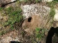
WOW, if that hozional hole is on about a 30 degree slope then its probably a anchor point, to me an owl means ( because of its ability to see in the dark ) look for shadows, the vertical drill hole has no meaning other than its to be measured by the foot, I need depth also to tell you how far it shows
Thanks for the information Dsty. I have a couple of questions. I suppose a person could make a drill hole for a lot reasons but if you have some that are used at a cache site, will there be something else in the site layout besides the drill holes, maybe carved letters or numbers.
Rick
Rick
rangler
Bronze Member
- Joined
- Jul 12, 2004
- Messages
- 1,320
- Reaction score
- 201
- Golden Thread
- 0
- Detector(s) used
- for solutions to the jesuit code -email pics to: randy_ferringer@yahoo.com
;rangler8@gmail.no locations needed! oro bro!
- Primary Interest:
- Other
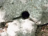
this hole is 3" wide and 2.5 deep...thanks dusty...
cryptic for sure
rangler ..

cryptic for sure
rangler ..

dsty
Bronze Member
- #16
Thread Owner
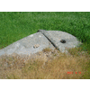
Hello Rangler, if the hole is stright up and down, can't see enough to say the direction, measure by the foot and it should be 189.5 feet as near as I can tell, kinda looks like a whale comming out of the water, I would follow the head and stay slightly to the right. Rangler the drill 3' X 2.5 I missed that if its like the others that I,ve seen its possibly 1/2 of 189.5 or aprox 96 feet, can't really say about the direction. There be a round hill in the vicinity that matches the whale looking feature, kinda like a map of sorts,showing the round hill and the ( drill hole = ) area of interest
Last edited:
Shortstack
Silver Member
- Joined
- Jan 22, 2007
- Messages
- 4,305
- Reaction score
- 419
- Golden Thread
- 0
- Detector(s) used
- Tesoro Bandido II and DeLeon. also a Detector Pro Headhunter Diver, and a Garrett BFO called The Hunter & a Garrett Ace 250.
- Primary Interest:
- All Treasure Hunting
hadj:
The bottom half of that rock looks like a lion's (or dog's) head, facing to the right.
The bottom half of that rock looks like a lion's (or dog's) head, facing to the right.
dsty
Bronze Member
- #20
Thread Owner
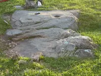
Hello, hadjioo9, I've seen this before a few years ago I believe, a turtle with a drill hole and a rabbit head with its ears layed back showing two trails, can't really tell if its two drill holes or just one, there may be a concealed information around the dril hole that may show up with paint inverted. It can be the trail is the direction of the turtle head, the rabbit may be showing a cache site or a trails divide symbol, the ears layed back may indicate its hideing, and because its just only a head I would vote for a cache site, the turtle may be the telling you that it can be followed both forward and reverse, its in the middle of the trail and there should be another cache site one league forward and in reverse with trail markers every 200 feet or so. The turtle should show 30 degrees and 220 degrees. Keep us posted, lets everyone help each other and get this figured. Happy trails Thank You
Last edited:
Similar threads
Users who are viewing this thread
Total: 1 (members: 0, guests: 1)


