no , one is doctor and one is bus driver and the other is my step son and dose yard work & tree cutter ...none of them care what I do and that's the way I want it .. if things go wrong .. I put it on the line I go where I feel I should no matter what ...my father was correct . if you know the area as well as the person that put it there you will find it ...if you can get to it the next thing ...
I was thinking about the Cibola\Ciuola thing, and found this:
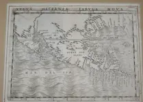
GIROLAMO RUSCELLI
NUEVA HISPANIA TABULA NOVA, 1561
"Thirteen years after Gastaldi published the map above, Ruscelli enlarged upon the previous edition, adding important innovations. The map of New Spain was significantly improved, correctly showing Yucatan as a peninsula, not an island. The place names along the upper GulfCoast revealed the explorations of Piñeda, Cabeza de Vaca and Moscoso. The Mississippi is carefully depicted as the “Rio de Spirito Santo” and the mythical City of Gold, Cibola (“Ciuola”), is shown. This is the first map to show Yucatan as a peninsula."
View attachment 1755880
Engraving; Dimensions: 22½ x 30.9 cm (9 x 12 in)
Published in Claudius Ptolemy, La Geographia… (Venice, 1561)
Ruscelli was an Italian cartographer.
This earlier fellow.
GIACOMO GASTALDI
NUEVA HISPANIA TABULA NOVA, 1548
"Gastaldi was a Piedmontese cartographer-publisher who was appointed cosmographer to the Republic of Venice. He published many maps including the important ameded edition of Ptolemy from which this map is taken. He was perhaps the best Italian cartographer of the sixteenth century. He was the first to posit the Bering Straits (Straits of Anian) in 1562. In this work, closely following Münster, he abandoned the woodcut and started to engrave on copper, producing the first set of engraved Ptolemy maps since 1508. After 1548, no edition of the Geographia was printed by woodblock, and the transition to engraving was complete. This edition was the most important Italian atlas of the century, and this is the first separate map of the Gulf Coast, Mexico and the present-day southwestern United States ever published."

"Engraving; Dimensions: 16½ x 20.3 cm (6 ½ x 8 in)
Published in La Geographia, from Claudius Ptolemy: Nicolo Bascarini (Venice, 1548)
Two volumes in one; 60 maps; small octavo bound in full vellum."
It appears these Italian cartographers used Cibola and Ciuola for the same place.
16th Century - Weems Collections


