What's new

New cellar hole found, first dig results.

Danimal

Bronze Member
Joined
Aug 16, 2006
Messages
1,142
Reaction score
165
Golden Thread
0
Location
Cuyahoga Falls, Ohio
Detector(s) used
duh...duh... DFX
I have been spending some time comparing 1903-1906 survey maps of the area around my home with satellite images trying to come up with a list of probable locations to hunt near home. So far my list of spots to check out is up to 15 and this afternoon my son Spencer and I went and checked out three.
The first two didn't pan out. The first one it was OBVIOUS where the house used to be, but construction barriers blocked our access.
The second one we obtained permission from the owner, but spent maybe an hour in the woods and found nada...no foundation, nothing but a few scrap metal bits and pcs.
The third one though ended up being a great old foundation with ANOTHER foundation off to the side that looked much much older. LOTS of trash and crap, but hey, that's what cellar hole hunting's about I have heard.
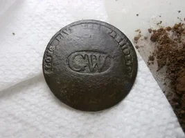
Ended up finding only one coin there (1917 wheatie) but found some other cool stuff:

1903 map showing the spot where the foundation is:
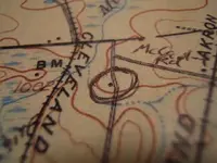
1-13hunt 007.webp
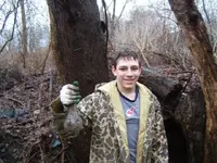
Spencer crawling carefully into a spot to retrieve a cool old bottle (couldn't be TOO old though...threaded top)
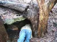
1-13hunt 001.webp
1-13hunt 002.webp
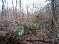
Pic of old foundation walls
1-13hunt 003.webp
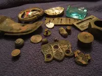
Cool finds cleaned up
1-13hunt 004.webp
Closeup of old bottle bottom..I really wish it were complete!
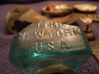
1-13hunt 005.webp
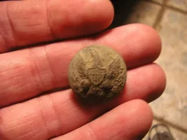
Closeup of old button (?) that has a small jewel in one end!
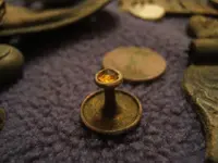
1-13hunt 006.webp

We'll be back there that's for sure!

HH all!!
 
Upvote 0
Ohhhh...cellarholes.....my favorite! You found the obligatory harmonica reed, Danimal. There's one at every cellarhole. ;D

The key to a great cellarhole is to first find an old atlas of the county that you live in from the 1800's. Compare it to the survey map from the 1900's. If the house isn't on the 1900's map then you've found a great place to hunt. Less garbage....and almost everything you dig will be a hundred years old. I have never found a large cent at a place that was occupied during the 20s, 30s, and 40s...probably because I'm too lazy to dig all the junk that they threw around. Just my observations on my cellarholes! ;)
 
Awesome finds. I bet there is a lot more there. The bottom picture almost looks like a cuff link....possibly? Just a thought. Anyways WTG!!

99Brown
 
Nice finds,I've seen old maps like that and didn't realize that the black dots were where house were?
 
The bottom pic looks like a cufflink. I have found a few myself. Thats what I always thought they were.

T
 
deadringer said:
That bottle looks like an orangina bottle, theye been around for a long time.
ParisOrangina.jpg

I see the similarity, but the one Spencer dug has a much taller neck and has a trheaded top like a screwcap would go on.
 
Very nice, and good research!

HH

Lonewolfe
 
That looks like a super place to hunt. I just got a look at a house in the middle of the woods that I am going to hunt. There is a small cemetary with three grave markers. The last person buried there was 1945. One of the others in 1915 and the other in the late 1800's. Wanna get some pics to post and hunt it hard. Happy Hunting.
 
:o What incredibly great finds! :o

And I really really liked the pictures of the foundations! ;D

Bogart :D
 
Still some cool finds. Good job of researching. Motor on!

Red Thunder
 
Several people have asked what I use to do the research for old cellarholes. Here's a few details:

I use Maptech's online historical maps of Ohio to look for early 1900's homes and/or churches

http://historical.maptech.com/

I then use Windows Live Local to get current satellite images:

http://local.live.com/

I like Windows Live Local better than Google Earth for two reasons...it seems to run faster and requires that no software be downloaded to your PC and more importantly, sometimes they have airplane images of the area you are looking at with a satellite image. When you switch to the "Bird's Eye View" the detail is incredible. I have found a lot of locations in N Ohio where the plane's view is available. You can also edit and save and email the images with imbedded pushpins, notes, etc.
I still use Google Earth too...sometimes the satellite images these two services differ...sometimes one has a summer images, the other fall (which shows old roads and trails better because of foilage decrease)

You can zoom in or out on the current image so the scale matches the Maptech maps, and place road intersections in the same spot on your monitor and toggle back and forth between images looking for areas that are now wooded/fields that once had homes. You can then look up through that county's tax records who owns the property and begin to try for permission to hunt.

good luck!!
 
Hey, Thanks for the info on locating cellar holes Danimal........I'll try that! ;) Keep us updated on your future finds.

HH,
Moon
 
Nice research Dan..Thanks for the info..

I have been using the maptech's with Goggle Earth..
I save the maptech image as a .jpg and then use the goggle "overlay" option to paste
the old map on the new goggle earth map. You can adjust the image to match the scale and
see both images at once or adjust the clarity. Once I find a location google gives me the GPS cords...

I really like Windows Live images a little better. And like you said..The bird's eye views are awesome.

All these tools are great for research.


ZoSo71
 
D,

nice group of artifacts you pulled up on that
first visit. Hope you find a bunch more.

Good job on doing your research, you earned
what looks like a good spot.

Nice pics, thanks for posting.

have a good un...................................
SHERMANVILLE
 
Great going on the research! Nice digs!
 
Nice work...thanks for the tips!
 

Users who are viewing this thread

Back
Top Bottom