New Question about 1715 Wreck + Barra dAys

MalabarII

Tenderfoot
Oct 17, 2008
9
0
New Question about 1715 Wreck + Barra d'Ays

Burgess and Clausen's book (Florida's Golden Galleon) continuously refers to "Barra d'Ays" (Bar of the Ais) as though that term meant "a thin section of barrier island."

All other uses of that term (by Mexia, by Romans, etc.) consistently refer to barrier island inlets, all of which have natural sandbars underneath them. I have never seen anyone use the term "Bar" to refer to thin sections of barrier island!

(Authors B&C themselves use the correct meaning of "Barra" when talking about the Bar of Matanzas--clearly NOT a thin section of barrier island!)

Given the blunders in B&C's book (pointed out in a Fla Hist. 1/4 review by E. Lyon), does anyone have any information pro or con regarding the meaning and usage of the term "Barra d'Ays?"

(Purpose: My co-author and I are preparing an article for publication in which we locate the archaeological remains of the paramount town of the Ais Indians, and the nearby Inlet of the Ais.)

thanks in advance,
Alan Brech
Palm Bay, FL
 

Re: New Question about 1715 Wreck + Barra d'Ays

You could try asking Clausen and Burgess directly what they may have meant. Burgess is still alive I believe and we all know Clausen is serving a life sentence up in Raiford or someplace like that.
 

Re: New Question about 1715 Wreck + Barra d'Ays

I actually did try to write to Clausen. I called the Correction System and got a life-hating receptionist who did not provide the correct information when I asked her how to address a letter to someone in prison.

I got the letter back as undelivered because a) I addressed him as "Dr."--NO TITLES ALLOWED! was written; and b) I did not have the right inmate number.

But even if I do get a letter through, I'm basically asking the guy to admit that his book had yet another error, so I doubt I'll get much. Thanks though.
 

Re: New Question about 1715 Wreck + Barra d'Ays

I think you should try again.He might like to get some mail in prison,right or wrong.Sad to hear
he is serving a life sentence.Hate to even know what for.Hope nothing to do with THing. Good
luck in the venture.HH Joe
 

Re: New Question about 1715 Wreck + Barra d'Ays

Even today, a sailor who dies is said to have "sailed over his last bar". The stretch of shallow water that forms off all inlets.

Chip V.
 

Re: New Question about 1715 Wreck + Barra d'Ays

as a seaman --when we die its called "crossing the bar"-- off of inlets of rivers going into the ocean theres often a shallow bar where the sand carried down steam by the rivers drops out at ---also theres the sand being washed ashore by the ocean that hits the river's ocean going stream coming into the ocean --which "piles" up sand -- the bar was a dangerous place for sailing ships with their often crude maps -- many a ship was wrecked in "strange waters far from home upon a bar at a foreign port they were visiting" -- Ivan
 

Re: New Question about 1715 Wreck + Barra d'Ays

Thanks Chip, Ivan, Joe for the information!
I'll try my letter to Clausen one more time with that info.

One more navigation question (you guys seem to know!) regarding "Barra" in Spanish Florida usage:

Q: Were "thin sections of barrier island" useful or important to the Spanish?* Would they have been useful or important features to any pre-modern navigators?

[The premise of this question is that, as a general rule, languages do not have words for things which are not useful to their economy, or important in their culture. If thin sections of barrier island are not a geographic item of concern to Spanish Florida and/or navigators, then the case against "Barra d'Ays" meaning both an inlet and a thin section of barrier island is that much stronger.]

* caveat: the thinness of the barrier island at the 1715 Camp site was, as Clausen pointed out, very helpful for defensive purposes. I accept that, but that was a one-time event, not the kind of ongoing concern that leads to new words or meanings being created.
 

Re: New Question about 1715 Wreck + Barra d'Ays

Q: Were "thin sections of barrier island" useful or important to the Spanish?* Would they have been useful or important features to any pre-modern navigators?

My answer would be "Yes". The indians and early Spanish explorers and navigators often used these narrow areas of island as "haul overs" for dragging light vessels such as canoes and launches from the ocean into the lagoon and vice versa.

Remember, 300-400 years ago there were not nearly the number of inlets we have today in Florida, and the natural inlets unpredictably opened and closed all the time.
 

Re: New Question about 1715 Wreck + Barra d'Ays

yes indeed things change --see the inlet map at the saint augustine light house web site --it has varied greatly over the years -- being spanish sailors used "dead reckoning" for a lot of the treasure ship era --- all land mass and land points were VITAL to finding out just where they where actually at.-- thats why the spanish ships sailed close to the coast to be able to SEE these old land based navagational aids of the day --and why being "sailing" vessels that depended upon the wind to move -- when a sudden storm came upon them with winds from the wrong directions they often got pinned into the coast and wrecked -- Ivan
 

Re: New Question about 1715 Wreck + Barra d'Ays

Alan, without giving too much of your book away, can you expound on this?:

Given the blunders in B&C's book (pointed out in a Fla Hist. 1/4 review by E. Lyon), does anyone have any information pro or con regarding the meaning and usage of the term "Barra d'Ays?"

What were the errors? What did Eugene have to say about them specifically?

I always tookthe Barra d' Ays to be a general location (the barrier island roughly from St Lucie to the old Ft. Pierce inlet) rather than a specific place. The Palmar D' Ays was of course in the Sebastian River area.

But I could be wrong........ ;D ;D ;D

Looking forward to your book.

ps. have you ever consulted with historian/conservator Doug Armstrong about this subject matter?
 

Re: New Question about 1715 Wreck + Barra d'Ays

Ivan: thanks for the info. Follow up Q:
How close to shore would a Spanish sailing ship (w/ telescope?) have to be in order to get a line-of-sight vantage point sufficient to make out differences in barrier island thickness? (yes, I'm not a sailor!)

I'm not trying to be nit-picky here, because I was wondering something similar regarding De Brahms maps of this area from 1772 etc.--that is, would a typical ocean voyager of that time have been able to see the Sebastian River? Would that have made a good landmark, or would it have been too easily missed?

Mad4: the name sounds familiar, and I'm willing to contact anyone. Send me his email to [email protected]. Also include title, etc.

Lyon's review of Burgess and Clausen is mostly favorable, but here are his gotchas:
"Some corrections are called for. The Spanish navigation system featured more than the New Spain and Tierra Firme fleets; guard ships, often integrated with the fleets, at times separate, also sailed. These were variously called the Armada Real, the Armada de Barlovento, or the Armada de Guardia. Crown revenues remitted with the fleets were far more complex than the quinto alone; among other funds, they included monies from what the authors term "The Holy Crusade," but which was actually the sale of indulgences. The Florida governor's name was not Corioles, but Corcoles. There were not two "Jennings raids" upon the salvage camps in November 1715 and January 1716, but rather one pirate occupation during January 1716, which was ended by a Spanish expedition from Havana (see A.G.I. Escribania de Camara 55-C, pieza 3). The authors seem to have confused and duplicated the data."
It's from the Florida Historical Quarterly, prob. soon after the book came out.
 

Re: New Question about 1715 Wreck + Barra d'Ays

In the 1700's, there was no Sebastian Inlet. South, the Ft' Pierce Inlet was several miles north of its present location.

There was a temporary natural inlet at Vero for a few years, I think in the 1800's.

St. Lucie inlet (Stuart) opened and closed, usually north of the present location a couple miles.

Ponce de Leon Inlet at Daytona has been open for centuries.

I know of no natural inlets north of Sebastian to the Indian River or Banana River.
 

Re: New Question about 1715 Wreck + Barra d'Ays

Bill: Our proposed Ais Inlet is not at Sebastian Inlet, nor is our proposed Town of Ais (although Lyon and Cato place "Winter" Ais in that area; the "orthodox" view, inherited from Woodbury Lowery [1909] is that Ais was two leagues north of the Old Indian River Inlet).

Also, I was asking Ivan about the Sebastian RIVER being visible from the ocean, and/or whether anyone writing an ocean sailing guide for pilots in 1772 would include the Sebastian River on the mainland as a landmark for ocean travelers.

The reason I asked is that Gerard De Brahm's 1772 Atlantic Pilot, based on his surveys of East Fla for the British, gives latitude readings for various landmarks, one of which is "Spanish Admiral Creek," an item not found in Romans' maps or surveys except in his mistaken reference to the shipwreck of the (sic) Spanish Admiral.
(De Brahms' latitude reading of 27 d. 40 m. for Spanish Admiral Creek places it well to the south of Romans' location of the Spanish Admiral shipwreck.)

If the Sebastian River is a useless landmark for 1772 voyagers (sailing north in the Gulf Stream) then it seems likely that De Brahm was instead referring to a small or vestigial inlet--either Bethel Creek (27 d. 40 m.) or our proposed Ais Inlet at the IRL Narrows.
 

Re: New Question about 1715 Wreck + Barra d'Ays

Also, I was asking Ivan about the Sebastian RIVER being visible from the ocean, and/or whether anyone writing an ocean sailing guide for pilots in 1772 would include the Sebastian River on the mainland as a landmark for ocean travelers.

I would think you could easily spy from the crow's nest on the mast of a sailing ship, the Sebastian River, over the low lying dunes of the barrier island.

By 1772 the area around the Sebastian River was fairly well known and mapped out. However, by that date the Ais had all but disappered, wiped out by European disease or assimilated into other tribes and relocated.

I don't have an email for Doug Armstrong but his home phone number is: 321-727-0221
 

Re: New Question about 1715 Wreck + Barra d'Ays

Burgess lives in Chattahoochee

Clausen lives in prison: see below

DC Number: N02787
Name: CLAUSEN, CARL J
Race: WHITE
Sex: MALE
Hair Color: GRAY OR PARTIALLY GRAY
Eye Color: BROWN
Height: 6'02''
Weight: 244 lbs.
Birth Date: 10/17/1936
Initial Receipt Date: 10/16/1997
Current Facility: CFRC-SOUTH
Current Custody: CLOSE
Current Release Date: 11/24/2044
(Release Date subject to change pending gain time award, gain time forfeiture, or review. A 'TO BE SET' Release Date is to be established pending review.)


--------------------------------------------------------------------------------
Aliases:
CARL J CLAUSEN CARL JON CLAUSEN
TONY


Scars, Marks, and Tattoos:
Type Location Description
TATTOO RIGHT SHOULDER PANTHER


Current Prison Sentence History:
Offense Date Offense Sentence Date County Case No. Prison Sentence Length
07/23/1997 2ND DEG.MURD,DANGEROUS ACT 10/15/1997 GADSDEN 9700508 50Y 0M 0D
07/23/1997 ATTEMPT MURDER LAW ENFORCE OFF 10/15/1997 GADSDEN 9700508 50Y 0M 0D


Note: The offense descriptions are truncated and do not necessarily reflect the crime of conviction. Please refer to the court documents or the Florida Statutes for further information or definition.

Incarceration History:
Date In-Custody Date Out-of-Custody
10/16/1997 Currently Incarcerated
 

Re: New Question about 1715 Wreck + Barra d'Ays

From the peanut gallery, There probably was a "overwash" , not a inlet, in the Sebastian River area from time to time, when we get "Fay type rains (25") and a north wind, the water backs up from the IRL narrows to Melbourne Beach. The over wash over the dunes would fill in quickly but all that water would be hunting for some place to go. Water comming out of the Sebastian river would help raise the water level also. My $.02 worth
 

Re: New Question about 1715 Wreck + Barra d'Ays

mad4wrecks said:
Q: Were "thin sections of barrier island" useful or important to the Spanish?* Would they have been useful or important features to any pre-modern navigators?

My answer would be "Yes". The indians and early Spanish explorers and navigators often used these narrow areas of island as "haulovers" for dragging their canoes and launches other light vessels from the ocean into the lagoon and vice versa.

Remember, 300-400 years ago there were not nearly the number of inlets we have today in Florida, and the natural inlets unpredictably opened and closed all the time.

Just south of Matanza Inlet a NEW inlet recently broke through. The immediate inland flooded and obviously now looks completely different. I imagine many times through history inlets opened and closed.
 

Re: New Question about 1715 Wreck + Barra d'Ays

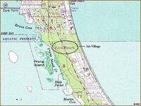
So, a "league" is 3.45 statute miles. If the old Ft. Pierce/Indian river inlet was about where the SEAL museum is, 7 miles north would put it near Riomar? Those old maps weren't real accurate. As for the mainland being visible, there is the "Bleech yard" at Jensen Beach, and Los tortolas (the turtles)..sand hills north of Ft. Pierce.

The inlet at Matanzas..due to all the inlet stabilization on the east coast, The south side has been eroding faster than usual. I'll bet the old A1A road finally washed through.

Matanzas is the last natural inlet on the east coast. Notice how sand migrates across the mouth of the inlet without being lost. Yoohoo..coastal engineers..take a lesson from yo momma..mother nature.
 

Attachments

  • ais.jpg
    ais.jpg
    76.9 KB · Views: 1,088
Re: New Question about 1715 Wreck + Barra d'Ays

a league could vary a lot in size depending upon the "time frame" -- the very old spanish league was 2.6 miles -- the more commonly used commonly more "modern" measure by both the spanish and the english standard leauge of 3 miles *--- even at a mere 15 leauges the differance is 6 miles !!! (39 miles using 2.6 per vs 45 at 3 per) - so you see knowing which standard they were using is vital --although "offically forbidden" to use the old measure many folks esp those from south america used them at sea for measuring distances and mapping charts for many many years --so if your working something directions wize and things do not seem to "add up" using your numbers try the old measure of 2.6 miles or 3 miles instead .
 

Top Member Reactions

Users who are viewing this thread

Back
Top