Navigation
Install the app
How to install the app on iOS
Follow along with the video below to see how to install our site as a web app on your home screen.
Note: This feature may not be available in some browsers.
More options
You are using an out of date browser. It may not display this or other websites correctly.
You should upgrade or use an alternative browser.
You should upgrade or use an alternative browser.
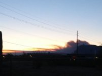
Not clouds
- Thread starter AbTexEx
- Start date
- Status
- Not open for further replies.
PotBelly Jim
Hero Member
- Dec 8, 2017
- 900
- 2,997
- Primary Interest:
- Other
Such a bummer...over 10k acres now.
there is a ton of smoke coming out of the north end of the mountains this morningSuch a bummer...over 10k acres now.
PotBelly Jim
Hero Member
- Dec 8, 2017
- 900
- 2,997
- Primary Interest:
- Other
there is a ton of smoke coming out of the north end of the mountains this morning
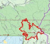
On the website this morning, it looked like Rogers Ridge was the eastern extent...with north winds...0% contained...not looking good. 450+ firefighters on hand...hope they all stay safe and make it through OK.
PotBelly Jim
Hero Member
- Dec 8, 2017
- 900
- 2,997
- Primary Interest:
- Other
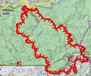
its definitely headed north into the wildernessJust updated 2 mins ago...13K acres now...map as of 2300 local last nite attached:
View attachment 1722862
PotBelly Jim
Hero Member
- Dec 8, 2017
- 900
- 2,997
- Primary Interest:
- Other
yep...just looked at JF Ranch Facebook page, the fire went through the yard but all people, buildings, etc. made it.
PotBelly Jim
Hero Member
- Dec 8, 2017
- 900
- 2,997
- Primary Interest:
- Other
PotBelly Jim
Hero Member
- Dec 8, 2017
- 900
- 2,997
- Primary Interest:
- Other
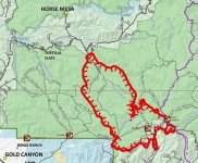
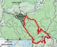
They back-burned around Tortilla Flat yesterday, and the plan was to do the same around any campgrounds and buildings along 88 as needed. They expect the fire to head W and NW in the next week, so it's possible this thing could make it all the way out of the wilderness on the northwest side...they also expect some spreading to the east but aren't sure how flammable the stuff at higher elevations will be, so who knows how bad it will get over there. Winds this week are expected to trend W/SW.
A hearty Father's Day salute to all the firefighter's bustin' their out there in this heat!


A hearty Father's Day salute to all the firefighter's bustin' their
 out there in this heat!

Last edited:
sdcfia
Silver Member
- Sep 28, 2014
- 3,723
- 9,034
- Primary Interest:
- Other
The FS Incident website contains all the current and projected information. https://inciweb.nwcg.gov/incident/6382/
PotBelly Jim
Hero Member
- Dec 8, 2017
- 900
- 2,997
- Primary Interest:
- Other
the monsoon season usually don't start until july..your prayers are definitely needed and appreciatedMaybe is time for a torrential rain out there. My prayers started.
somehiker
Silver Member
- May 1, 2007
- 4,365
- 6,431
- Primary Interest:
- All Treasure Hunting
With the better accessibility #88 gives to fire crews, that water bombers and helos can get low and over at Mesquite Flats....and once North of the SWA boundary areas, start using FR chemicals....they might just be able to stop it at 88. If not, looks like it's probably going to reach the river in the next couple of days. According to the MODIS website, the area affected has grown 33% since yesterday.
Last edited:
Gregory E. Davis
Sr. Member
- Oct 22, 2013
- 335
- 1,012
- Detector(s) used
- eyeball it
- Primary Interest:
- All Treasure Hunting
Hello all: I am not one to wish a fire on anyone or place but let's face it, this has been a long time coming. Since the cattle were removed from the Superstition Region by the Forest Service the vegetation has grown completely out of control. Some of the canyons trails are so overgrown that one cannot get through. Maybe now when the fall hiking season starts we will be able to better explore the region. Who knows? Maybe the coming rains will reveal the LDM? Cordially, Gregory E. Davis
somehiker
Silver Member
- May 1, 2007
- 4,365
- 6,431
- Primary Interest:
- All Treasure Hunting
That's one thing I've considered Greg.
Another though, is how much hotter is will be come late October, when I usually go in for a look around. It's almost always in the high 90's by midday, unless you are up high somewhere. Some days even over 100.
I did notice on one of the websites tracking the fire, that they said it was being fueled by and consuming mostly brush and grass up to 2' high. One of the reasons it's moving so fast I guess, and quickly burning out behind the fronts. The mesquite and larger cacti will probably be fine, as will most of the larger hardwoods I expect. So maybe in the end it won't be too bad.
Last edited:
exactly greg...when they ran the cattlemen off the range they were just begging for a fire...cattle are natures lawnmowersHello all: I am not one to wish a fire on anyone or place but let's face it, this has been a long time coming. Since the cattle were removed from the Superstition Region by the Forest Service the vegetation has grown completely out of control. Some of the canyons trails are so overgrown that one cannot get through. Maybe now when the fall hiking season starts we will be able to better explore the region. Who knows? Maybe the coming rains will reveal the LDM? Cordially, Gregory E. Davis
Oroblanco
Gold Member
- Jan 21, 2005
- 7,841
- 9,848
- Detector(s) used
- Tesoro Lobo Supertraq, (95%) Garrett Scorpion (5%)
Hello all: I am not one to wish a fire on anyone or place but let's face it, this has been a long time coming. Since the cattle were removed from the Superstition Region by the Forest Service the vegetation has grown completely out of control. Some of the canyons trails are so overgrown that one cannot get through. Maybe now when the fall hiking season starts we will be able to better explore the region. Who knows? Maybe the coming rains will reveal the LDM? Cordially, Gregory E. Davis
Amen to that! By making a 'wilderness' out of the area, keeping all of the livestock OUT, has resulted in the predictable, the brush grows in very thick, dries out and only needs a spark to burn out of control. Add wind and presto its a disaster.
Thanks to those keeping us posted,


- Status
- Not open for further replies.
Top Member Reactions
-
 3669
3669 -
 1992
1992 -
 1880
1880 -
 1493
1493 -
 1246
1246 -
 1103
1103 -
 1078
1078 -
 986
986 -
 856
856 -
 727
727 -
 657
657 -
 574
574 -
 485
485 -
 470
470 -
 438
438 -
E
429
-
 398
398 -
 393
393 -
 391
391 -
 381
381
Users who are viewing this thread
Total: 2 (members: 0, guests: 2)
