I think you are talking out of your posterior. I'm a professional cartographer and I've studied map making in the Americas for years. I'll share with you some of what I have learned. Please notice I have included links to some information that may help you understand map making in Arizona during this time period.
First - the Spanish had some very good mapmakers but the Portuguese, Dutch and later the French were the masters of map making during this time. During the colonial period all the powers carefully guarded their maps and map making techniques. Maps were state secrets much like atomic fusion or hypersonic missiles are today. You can't conquer new lands if you don't know where you are. For this reason the Jesuits could not copy the "Spanish style" because they weren't allowed to study the current Spanish maps of the time. It wasn't a matter of secret map codes, the world powers didn't need codes on their maps because they protected the physical maps themselves. If an explorer or army needed a map one was drawn with just the features needed for the job, nobody got free access to the whole map except the rulers.
Second - you are assuming the Jesuits were Spanish. This was rarely true. Most Jesuits were university educated French, Croatians and Italians.
Father Kino was Italian. He received his university education in Innsbruck Austria.
Third - Father Kino was one of the most accomplished mapmakers of his time. His most famous map was
Passage by Land to California. Discovered by Father Eusebius Francis Kino, a Jesuit, Between the Years 1698 & 1701 Containing Likewise the New Missions of the Jesuits. That map changed the world and is still famous today as one of the most influential maps in history both for the fact he proved California was not an island and for the quality of the mapping work.
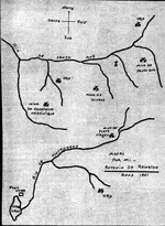
Here are some things that are important to notice on the above Kino map:
- The area North of Casa Grande all the way to Moqui is left blank except for the word "Apaches". It wasn't until after the Spanish era that the area North of Casa Grande, including the Superstitions, was explored.
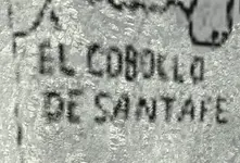
- See how Casa Grande is spelled with that funny thing that looks more like an f than an s? That is an s written in the style of the time - it's called a long s and it was used in the Roman alphabet until the early 19th century no matter what language it was written in. There was a set of rules when to use the long s as opposed to a regular (round) s. This is a very important letter when you are studying old writings - if there is no long s then the writing is not historical it's modern.
- The title of the map includes "the new missions for the Jesuits". If you had any question about what missions and Spanish settlements existed at the time this very detailed map gives each location and the ranch owner. It is by far the most accurate and reliable account of the extent of Spanish settlement in Arizona.
Father Kino was also well known for his scientific writings about determining accurate map positioning and how to conform a map to latitude and longitude. So much for your theory that Spanish, Jesuit or any other mapmakers didn't employ cardinal positioning. Maybe actually look at some Spanish maps from that time period, it will be immediately obvious that no matter what country made the maps they all used cardinal positioning.
So you have one of the greatest mapmakers of the time living, mapping and working in Southern Arizona
. If there was any mapping knowledge passed down from Kino it was the best quality available. Assuming Spanish mapmakers were idiots or bumbling fools that didn't know how to spell common words or relied on the position of rocks to guide their grammar are very weak theories unsupported by history or practice.