
You are using an out of date browser. It may not display this or other websites correctly.
You should upgrade or use an alternative browser.
You should upgrade or use an alternative browser.
Persistent Claims of a Hoax
- Thread starter gjb
- Start date

gazzahk
Bronze Member
- Joined
- Nov 14, 2015
- Messages
- 1,728
- Reaction score
- 2,594
- Golden Thread
- 0
- Primary Interest:
- All Treasure Hunting
Dig a bit deeper and not just what is handed out for the TV show.
Here's a copy of the (spanish origin) map published in 1934. The image shows how it was oriented (to north), scaled and physically laid out on the island from the start to determine where to dig. It's why Dan Blankenship used to say the treasure was of spanish origin. Green circle is the money pit.
View attachment 1703411
It is talked about in all the original reports. Just ask Doug. They, like the map, are easy to find.
View attachment 1703414
Read the original documents 1860s there is no reference to Spanish treasure maps.
That map is in English...
There is no mention of the map being a Spanish treasure map...
There in no mention of D.McGinnis map being in Spanish that I have ever seen
Of even greater interest was learning that George’s grandfather had an old treasure map that had been passed down in his family through the years. Imagine being able to look at an old Oak Island treasure map! I was very dismayed to learn that the map was lost in a house fire long ago. George says that they tried to recreate the map but never succeeded because “everything changed” and the landmarks were gone. This information may be supported by early accounts of the Money Pit discovery such as,"A Search for Pirate Gold" written in 1899 by James Clarence Hyde, which specifically mentions that Daniel McGinnis had been in possession of a treasure map.
https://www.oakislandcompendium.ca/...s-the-story-of-an-oak-island-familys-treasure
Where does the Spanish come from?
The reports of an "alleged" treasure map are well after the first few search attempts... So how could it be the original reason?
Last edited:
dmg2016
Jr. Member
- Joined
- Feb 8, 2019
- Messages
- 28
- Reaction score
- 32
- Golden Thread
- 0
- Primary Interest:
- All Treasure Hunting
Below is the earliest reference to a possible Spanish map that I am aware of and it is fringe at best.
1906 - The Lure of the Pirate's Gold by Josephine Freda
There is no mention of a Spanish map in the next link below, but it is a well-researched report linking Oak Island to the Spanish.
1971 - The Spanish in Nova Scotia in the 16th Century: A Hint in the Oak Island Treasure Mystery by Ross Wilhelm
1906 - The Lure of the Pirate's Gold by Josephine Freda
There is no mention of a Spanish map in the next link below, but it is a well-researched report linking Oak Island to the Spanish.
1971 - The Spanish in Nova Scotia in the 16th Century: A Hint in the Oak Island Treasure Mystery by Ross Wilhelm
MikeN
Sr. Member
- Joined
- Feb 22, 2017
- Messages
- 489
- Reaction score
- 590
- Golden Thread
- 0
- Primary Interest:
- All Treasure Hunting
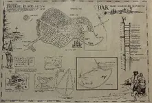
Speaking of treasure maps, there's this ancient treasure map from '79 . (1979, that is) I got it from the Oak Island gift shop in 1992. It was originally created and sold by The Book Room in Halifax, which closed in 2008 after 169 years of operation.

Stretch Da Truth
Bronze Member
- Joined
- Jan 13, 2017
- Messages
- 1,038
- Reaction score
- 1,097
- Golden Thread
- 0
- Detector(s) used
- XP Déus & a Carrot!
- Primary Interest:
- Metal Detecting
Speaking of treasure maps, there's this ancient treasure map from '79 . (1979, that is) I got it from the Oak Island gift shop in 1992. It was originally created and sold by The Book Room in Halifax, which closed in 2008 after 169 years of operation.
View attachment 1704200
Ill give ya 50 quid for the bloody map Mike!!! Arrrrrrr!!!!
gjb
Sr. Member
- #86
Thread Owner
Dig a bit deeper and not just what is handed out for the TV show.
Here's a copy of the (spanish origin) map published in 1934. The image shows how it was oriented (to north), scaled and physically laid out on the island from the start to determine where to dig. It's why Dan Blankenship used to say the treasure was of spanish origin. Green circle is the money pit.
It is talked about in all the original reports. Just ask Doug. They, like the map, are easy to find.
As far as I'm aware, this map was first published in 1935, but it originally had nothing to do with Oak Island. It's a purported pirate treasure map of Coquimbo and Guayacan from El Tesoro do los Piratas de Guayacan by Ricardo E. Latcham. As you so rightly say, this particular map is easy to find!

rowanns
Full Member
- Joined
- Jan 26, 2014
- Messages
- 183
- Reaction score
- 154
- Golden Thread
- 0
- Location
- Nova Scotia
- Detector(s) used
- Garrett
- Primary Interest:
- Metal Detecting
That's the map I grew up with Mike. Thanks for sharing!
gjb
Sr. Member
- #88
Thread Owner
Below is the earliest reference to a possible Spanish map that I am aware of and it is fringe at best.
1906 - The Lure of the Pirate's Gold by Josephine Freda
As I've pointed out on a few occasions here, my research points to the Fredea story as being a slightly garbled account of the first published record of a set of seven treasure maps that were to resurface thirty years later as the so-called Kidd Maps, which were at that time in the hands of a group of dilettante treasure hunters.
The earliest record the group had of the treasures they were looking for dated back to the mid-18th century. They believed that the island in question was Juan Fernandez - which explains why the present outlines of these maps bear such a close resemblance to 17th and 18th century maps of that island.
The outlines we see today are not original, and from correspondence in my possession it becomes clear that it was Harold Wilkins who correctly identified the island as Des Barres' Gloucester Island in Mahone Bay and that, thus, all seven sets of cryptic instructions very likely pertained to Oak Island. There was no suggestion at all that the instructions had anything to do with pirates. Wilkins tried to get a concession on the island in the late 1940s, but the consortium broke up. He kept very quiet about this, but the details are in his correspondence.
We only have five sets of instructions, but these identify points on the figure below which is from a pure geometrical construction that places the Drilled Rocks, the Welling and Mallon Triangles and the Money Pit:
View attachment 1705732
The instructions all conform to a common format:
Identify three points of a triangle offset from the features noted above (Pit, Rocks, Triangles)
Form a triangle and find its centre
Take an offset (generally in the form a + b + ac in the direction of the centre point of the design
Note that the Tree in all cases is actually the centre of the Money Pit. For example, one map gives us:
(Read the first two lines in reverse.)
18 NE by 71 W on Rock -> Rocks; 71W and 18NE
26 ENE by 18 SW Palm -> Tree: 18 fathoms SW and then 26 fathoms ENE
7 feet by 7 feet by 8 -> 7 feet + 7 feet + (8 x 7 feet) = 70 feet (towards the central point)
Meaning: Identify a point 71 fathoms west of the East Rock, a point 18 fathoms northeast of the West Rock, and a point 18 fathoms southwest of the Money Pit thence proceeding 26 fathoms ENE. Find the centre of the triangle thus formed and proceed east for 70 feet (7 feet then another seven feet then eight times seven feet). This spot is the third from the left in the above diagram.
The two Palmer maps are fourth from the left (topmost - 3 feet by 3 feet by FOUR = 18 feet) and sixth from the left (360 yards V.R. North). There is no map for the Cave-In Pit, but it’s interesting that somebody dug a hole some 18 feet deep at that point and then filled it in.
The maps are so disparaged by all and sundry that the truth about their origins is readily dismissed without a second thought. People claiming that no sensible and rational person would credit such a background to Oak Island simply ignore the fact that the originator would not have thought about things the same way as we do. Those claiming Oak island is a hoax will simply state that the maps' instructions all work mathematically purely by accident.
These are all highly sophisticated mechanisms for identifying precise points in a pattern on the ground (to within a foot of target) - it’s not the work of your average pirate. If you’re at all interested in the underlying geometry and the detailed workings of the instructions then you might wish to take a look at a web site (link below) that I prepared many years ago before publishing my Oak Island books:
Maps, Mystery and Interpretation
It's not really necessary to have an understanding of geometry and trigonometry, but this could be an interesting school project in math and history.
namxat
Sr. Member
- Joined
- Feb 2, 2017
- Messages
- 466
- Reaction score
- 648
- Golden Thread
- 0
- Primary Interest:
- All Treasure Hunting
Perhaps some people will not like the following since it is harsh verdict but:
1) All things about intervall platforms, stones with inscribtions, coconut fibres are only hearsay, I have never seen the artifacts. They are "lost".
2) Even for a treasure, the whole shebang with a thirty metre shaft and float tubes is overdone. Dig two meters and leave no traces would have been better, or? And no, it was not technically possible three hundred years ago, since you did hit the water table.
3) Speaking of water table. If you dig on an island a few yards from the sea, your hole will become flodded. No magic or templars involved. Even in rock, since rock is almost always riddled with faults and cracks. Otherwise tunneling and underground mining would be a lot easier.
4) And since your hole is flodded you can put a dye in it and it will eventually seep into the sea. Again, no magic or templars involved.
5) Off course the story gets spicier with Templars and Francis Bacon and who not. Maybe Aliens? Maybe the Nazis built a time machine and travelled three hundred years back to bury yamashitas gold.
6) The current TV is exactly that: A TV show. And as such a work of fiction or more harshly a scam. Highly likley that the producers pay for the digging in one way or the other.
I personally have an absolutely good lead to a Nazi treasure in the Austrian Alps. If someone knows a TV producer with a budget of a few million bucks, I would bother to go there and take a look.
Greets Namxat
1) All things about intervall platforms, stones with inscribtions, coconut fibres are only hearsay, I have never seen the artifacts. They are "lost".
2) Even for a treasure, the whole shebang with a thirty metre shaft and float tubes is overdone. Dig two meters and leave no traces would have been better, or? And no, it was not technically possible three hundred years ago, since you did hit the water table.
3) Speaking of water table. If you dig on an island a few yards from the sea, your hole will become flodded. No magic or templars involved. Even in rock, since rock is almost always riddled with faults and cracks. Otherwise tunneling and underground mining would be a lot easier.
4) And since your hole is flodded you can put a dye in it and it will eventually seep into the sea. Again, no magic or templars involved.
5) Off course the story gets spicier with Templars and Francis Bacon and who not. Maybe Aliens? Maybe the Nazis built a time machine and travelled three hundred years back to bury yamashitas gold.
6) The current TV is exactly that: A TV show. And as such a work of fiction or more harshly a scam. Highly likley that the producers pay for the digging in one way or the other.
I personally have an absolutely good lead to a Nazi treasure in the Austrian Alps. If someone knows a TV producer with a budget of a few million bucks, I would bother to go there and take a look.
Greets Namxat

rjw4law
Bronze Member
I would not jump as far as a Hoax....these guys have a huge investment. DO they get into the vault? Ok, what's there? I believe the tantalizing episodes that go on and on are based on entertainment to bring us back every week. (Money making air time also} Just like all of our efforts out there, the proof in the last hole dug. Not necessarily a hoax...just a dream.
ECS
Banned
- Joined
- Mar 26, 2012
- Messages
- 13,321
- Reaction score
- 17,697
- Golden Thread
- 0
- Location
- Ocala,Florida
- Primary Interest:
- Other
Not necessarily a hoax... but a tall tale that has gotten bigger with the telling.
gazzahk
Bronze Member
- Joined
- Nov 14, 2015
- Messages
- 1,728
- Reaction score
- 2,594
- Golden Thread
- 0
- Primary Interest:
- All Treasure Hunting
So far they have shown us 86 hours of tv episodes looking for a treasure on OI. In that time they have not found a single piece of treasure or even a single piece of evidence of treasure being buried there. They now are going to have another season... It must be getting pretty close to a hoax/con job. They cannot still believe there is a treasure buried there. The effort is now simply about milking sponsors/audience for as much money as they can until viewer ratings disappear... I do not think the show is any longer an honest attempt to find a treasure on oak Island...Not necessarily a hoax... but a tall tale that has gotten bigger with the telling.

sky355
Full Member
- Joined
- Jul 24, 2012
- Messages
- 145
- Reaction score
- 74
- Golden Thread
- 0
- Location
- Littleton Colorado
- Detector(s) used
- Minelab Equinox 600
Fisher F22
Vibra tector 740
- Primary Interest:
- All Treasure Hunting
So far they have shown us 86 hours of tv episodes looking for a treasure on OI. In that time they have not found a single piece of treasure or even a single piece of evidence of treasure being buried there. They now are going to have another season... It must be getting pretty close to a hoax/con job. They cannot still believe there is a treasure buried there. The effort is now simply about milking sponsors/audience for as much money as they can until viewer ratings disappear... I do not think the show is any longer an honest attempt to find a treasure on oak Island...
I disagree they have found tremendous amount of artifacts. The cross the coins the 2 Broaches they pulled up last year. Id say they are doing alright. I do agree they need more people combing the island with Metal Detectors. If you got a team together and put 1 MD on every 100 yards I bet they would find a lot more stuff.

gallileo60
Hero Member
- Joined
- Apr 30, 2007
- Messages
- 971
- Reaction score
- 84
- Golden Thread
- 0
- Location
- Gulf Coast, Texas
- Detector(s) used
- AT Pro, Bounty Hunter Land Star, Ace 250, Garrett 1350
- Primary Interest:
- All Treasure Hunting
Its just a TV show with the same basic formula as a lot of them now days...As far as Oak Island goes..It just doesn't make sense that anything would be left there, if it ever was there to begin with...I love a good legend as much as the next guy, but some of this is pretty far fetched...Crazy depths, no tangible proof of anything really..Still its fun...l.
gazzahk
Bronze Member
- Joined
- Nov 14, 2015
- Messages
- 1,728
- Reaction score
- 2,594
- Golden Thread
- 0
- Primary Interest:
- All Treasure Hunting
None of those finds in anyway support a treasure was buried on OI. They simply show people have been living/visiting on OI for a few hundred years at least. NOTHING HAS BEEN FOUND to support treasure being buried there...I disagree they have found tremendous amount of artifacts. The cross the coins the 2 Broaches they pulled up last year.....
Raparee
Hero Member
- Joined
- Feb 18, 2016
- Messages
- 677
- Reaction score
- 670
- Golden Thread
- 0
- Location
- Nova Scotia
- Primary Interest:
- All Treasure Hunting
I disagree they have found tremendous amount of artifacts. The cross the coins the 2 Broaches they pulled up last year. Id say they are doing alright. I do agree they need more people combing the island with Metal Detectors. If you got a team together and put 1 MD on every 100 yards I bet they would find a lot more stuff.
They didn't really find anything that couldn't have been found just about anywhere in NS.
gazzahk
Bronze Member
- Joined
- Nov 14, 2015
- Messages
- 1,728
- Reaction score
- 2,594
- Golden Thread
- 0
- Primary Interest:
- All Treasure Hunting
Here is a great summary of how little has been found and how much "spin" has been attached to those "not treasure related" finds..
https://www.bostonstandard.co.uk/ne...to-unravel-the-200-year-old-mystery-1-8911230
https://www.bostonstandard.co.uk/ne...to-unravel-the-200-year-old-mystery-1-8911230

etex
Bronze Member
- Joined
- Feb 20, 2013
- Messages
- 1,174
- Reaction score
- 2,067
- Golden Thread
- 0
- Location
- Longview, Texas
- Primary Interest:
- All Treasure Hunting
It doesn’t even list the Roman Sword in the top twenty, what a travesty [emoji35]

Charlie P. (NY)
Gold Member
- Joined
- Feb 3, 2006
- Messages
- 13,215
- Reaction score
- 17,441
- Golden Thread
- 0
- Detector(s) used
- Minelab Musketeer Advantage Pro w/8" & 10" DD coils/Fisher F75se(Upgraded to LTD2) w/11" DD, 6.5" concentric & 9.5" NEL Sharpshooter DD coils/Sunray FX-1 Probe & F-Point/Black Widows/Rattler headphone
- Primary Interest:
- Metal Detecting
It doesn’t even list the Roman Sword in the top twenty, what a travesty [emoji35]
Yes. If there was any justice in the world that would be in stolen valor "commander" (not really) jovan philyaw/hutton/pulitser's liver.




Featured Treasure Finds
Featured Treasure Finds
Similar threads

- Replies
- 156
- Views
- 10K


Users who are viewing this thread
Total: 3 (members: 0, guests: 3)















