- #1
Thread Owner
A user on this forum (Oak Island Sage) who has identified himself as the author Cerris Francis (Oak Island Treasure Revelations) has been repeatedly claiming that there exists a 17th century authentic treasure map drawn by Captain Kidd (or his shipmate John Ware) and the island depicted on this map is Oak Island. Francis has claimed this in several posts and repeats the claim in his book. He has further alleged that "experts" have authenticated the map by examining its handwriting and a signature by Kidd on the map.
Quote from the book (page 146 [Kindle Edition]):
I decided to do some research and fact check his claims. It did not surprise me to learn, Oak Island Sage is demonstrably wrong about virtually everything he claims about this map.
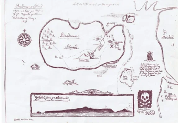
The first thing to note is the map in Francis' book is not an image of an original map but a heavily embellished copy of a map on parchment Edward Rowe Snow claims he purchased from a New York dealer. The embellished map (see above) was drawn by Snow c. 1946 and contains "Edward Rowe Snow" as a copyright (bottom left).

(c) 1946 Edward Rowe Snow.
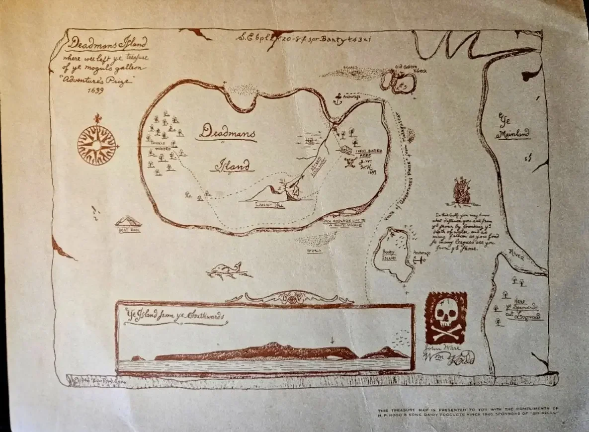
The reason Snow drew this map is the same year - H. P. Hood and Sons Dairy used it as a marketing gimmick to promote their dairy products. Buyers as a premium or mail-in item could get a copy of Snow's Deadman's Island map. At the same time, H. P. Hood and Sons Dairy sponsored a radio station show that aired on WNAC (Boston) called "Six Bells" narrated by Edward Rowe Snow.
H. P. Hood and Sons Dairy copied Snow's (1946) embellished map verbatim but printed it on brownish paper to give it the appearance of being centuries old.
The bottom right of the map reads:
"THIS TREASURE MAP IS PRESENTED TO YOU WITH THE COMPLIMENTS OF H. P. HOOD & SONS DAIRY PRODUCTS SINCE 1846 SPONSORS OF 'SIX BELLS'"
Edward Rowe Snow's name also appears near the bottom (left) as a copyright.
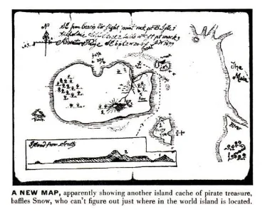
A reproduction of the original (non-embellished) map can be found in the American news magazine LIFE (21 July 1952):
The original map on parchment Snow claims he bought from a New York Dealer:
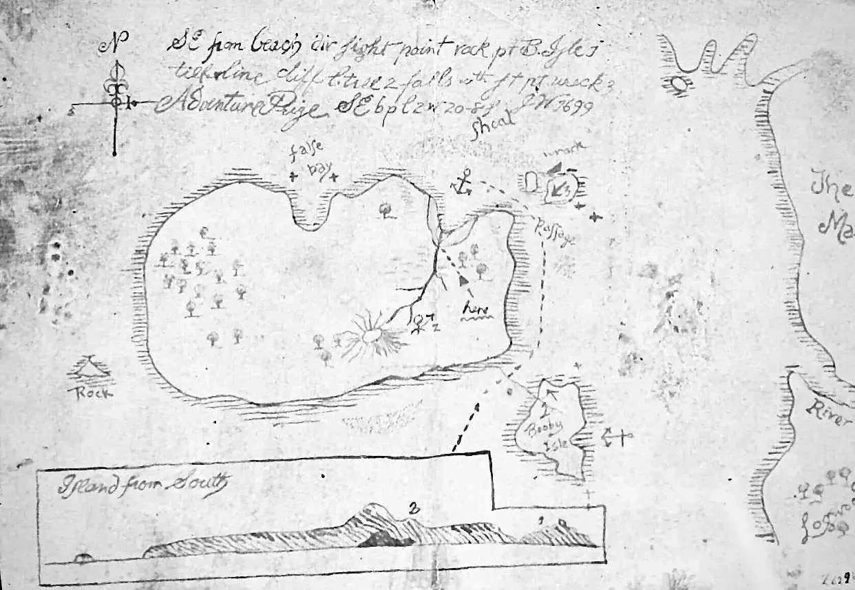
As you can clearly see, Snow embellished the map for H. P. Hood and Sons Dairy in 1946 and added many features or details not on the original; he also changed some of the writing. For example, he altered the word "The [Main]" on the original map, to "Ye [Main]" (see right of map). He added a name to the island (not on the original map): Deadman's Island, as well as added a Jolly Roger flag and Captain Kidd's signature (near bottom right). He also added fictional pirate tropes to the map such as "X marks the spot" and changed the volcano on the main island to a hill; annotated "Lookout Hill".
The additions as embellishments by Snow such as pirate motifs (a mixture of fictional and historical) make sense since the map was used as a marketing gimmick by H. P. Hood and Sons Dairy.
Now turning to Oak Island Sage's specific claims (from his book):
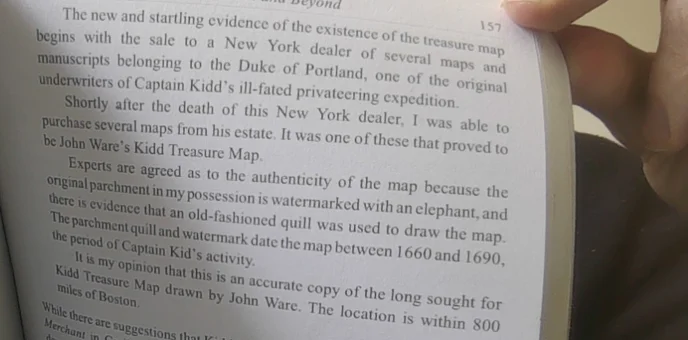
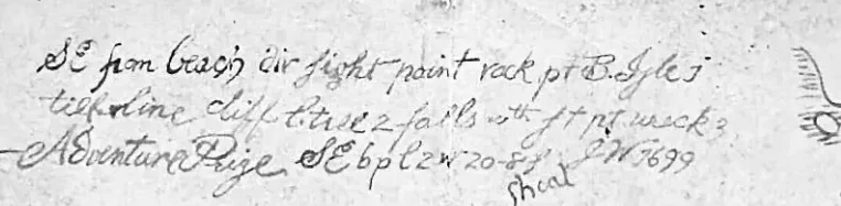
Oak Island Sage has therefore misread what Snow actually said. Snow never claimed any experts examined the handwriting or signature on the original map on parchment. The latter is in fact impossible since the original map contains no signatures (see above). The William Kidd signature was added by Snow on his embellished map - it does not appear on the original. There is, however, handwriting (see top of map or below) and John Ware's initials J.W. Snow does not though state experts examined the handwriting including initials:
Here is what Snow actually said (quoted above in Gjb's book):

 fountainpenhistory.blogspot.com
The fact the parchment has a watermark does not exclude the possibility that while the parchment dates to the 17th century, the map drawing and handwriting dates centuries later. Indeed, forgers or hoaxers often use old parchments to pass-off fake treasure maps as authentic, so we should not expect modern paper. As an example, we know the Kidd-Palmer maps are an early 20th century hoax, but at least one of these maps was drawn on an early 18th century parchment. Therefore the map on the parchment in Snow's possession could have easily been drawn in the early 20th century. This is very probable when it is realised, that Snow did not ask an expert to examine the style of the handwriting (Oak Island Sage made that up) and the provenance of the map cannot be traced before the 1940s. Snow claims he purchased it from a New York dealer and that it came from the estate of the Duke of Portland. This is dubious at best and is not verifiable.
Continuing from Oak Island's Sage's comment:
Furthermore, the parchment map appears to have borrowed from or at least been inspired by the map in Treasure Island (1883). I touched upon this in an earlier comment:
Finally, Oak Island Sage states:
Will Oak Island Sage retract the falsehoods in his book Oak Island Treasure Revelations and acknowledge the parchment map is a hoax?
Quote from the book (page 146 [Kindle Edition]):
A few of his posts:A now deceased writer called Edward Lowe Snow collected all kinds of things pertaining to pirates, including old treasure maps; he purchased several from a New York dealer. One map, entitled The Deadmans Island Map, was so exciting that he hired experts who, after examining it, verified Lowe's own suspicions; it was indeed the authenticated handwriting and signature of Captain William Kidd. Edward Lowe Snow displayed the vital map signed by both John Ware and William Kidd, and it was illustrated in Life Magazine. Several more experts concurred that the handwriting was indisputably that of Captain Kidd himself. It’s something a handwriting expert today could verify. Personally speaking, I have no doubts at all. Edward Snow had no idea of where the island depicted on the old parchment map actually was. I sincerely believe it is Oak Island, and you can judge for yourself when I point out the important similarities.
I mean no offence but you are wrong, the Deadman Island map was genuinely drawn by the over confident Captain Kidd.
One of his posts mentions "handwriting experts":CaptGeorge, I don't know if you are referring to the China Sea map and The Deadman Island map, if you are but sorry they were definitely drawn by Captain William Kidd and/or John Ware.
He further claims Kidd's signature on the map has been authenticated as genuine by these same experts:The Deadman Island map was examined and authenticated by handwriting experts who declared that it was definitely drawn by Captain William Kidd, it clearly reveals in his own handwriting that the Adventure Prize was taken there and it anchored in Joudary Cove.
Francis' book contains the following map (Deadman's Island):I have no intention arguing with you especially regarding the authenticity of Deadman's Island map, and William Kidd signature, as far as I and previous experts were concerned it is genuine
I decided to do some research and fact check his claims. It did not surprise me to learn, Oak Island Sage is demonstrably wrong about virtually everything he claims about this map.
The first thing to note is the map in Francis' book is not an image of an original map but a heavily embellished copy of a map on parchment Edward Rowe Snow claims he purchased from a New York dealer. The embellished map (see above) was drawn by Snow c. 1946 and contains "Edward Rowe Snow" as a copyright (bottom left).
(c) 1946 Edward Rowe Snow.
The reason Snow drew this map is the same year - H. P. Hood and Sons Dairy used it as a marketing gimmick to promote their dairy products. Buyers as a premium or mail-in item could get a copy of Snow's Deadman's Island map. At the same time, H. P. Hood and Sons Dairy sponsored a radio station show that aired on WNAC (Boston) called "Six Bells" narrated by Edward Rowe Snow.
H. P. Hood and Sons Dairy copied Snow's (1946) embellished map verbatim but printed it on brownish paper to give it the appearance of being centuries old.
The bottom right of the map reads:
"THIS TREASURE MAP IS PRESENTED TO YOU WITH THE COMPLIMENTS OF H. P. HOOD & SONS DAIRY PRODUCTS SINCE 1846 SPONSORS OF 'SIX BELLS'"
Edward Rowe Snow's name also appears near the bottom (left) as a copyright.
A reproduction of the original (non-embellished) map can be found in the American news magazine LIFE (21 July 1952):
The original map on parchment Snow claims he bought from a New York Dealer:
As you can clearly see, Snow embellished the map for H. P. Hood and Sons Dairy in 1946 and added many features or details not on the original; he also changed some of the writing. For example, he altered the word "The [Main]" on the original map, to "Ye [Main]" (see right of map). He added a name to the island (not on the original map): Deadman's Island, as well as added a Jolly Roger flag and Captain Kidd's signature (near bottom right). He also added fictional pirate tropes to the map such as "X marks the spot" and changed the volcano on the main island to a hill; annotated "Lookout Hill".
The additions as embellishments by Snow such as pirate motifs (a mixture of fictional and historical) make sense since the map was used as a marketing gimmick by H. P. Hood and Sons Dairy.
Now turning to Oak Island Sage's specific claims (from his book):
This claim is entirely unsourced. However, Sage in his book credits "Geoff Bath" (Gjb) as providing him a copy of the Deadman's Island map. If we then turn to Bath's (2013) book, to quote Snow:A now deceased writer called Edward Lowe Snow collected all kinds of things pertaining to pirates, including old treasure maps; he purchased several from a New York dealer. One map, entitled The Deadmans Island Map, was so exciting that he [Edward Rowe Snow] hired experts who, after examining it, verified Lowe's [Rowe's] own suspicions; it was indeed the authenticated handwriting and signature of Captain William Kidd.
Oak Island Sage has therefore misread what Snow actually said. Snow never claimed any experts examined the handwriting or signature on the original map on parchment. The latter is in fact impossible since the original map contains no signatures (see above). The William Kidd signature was added by Snow on his embellished map - it does not appear on the original. There is, however, handwriting (see top of map or below) and John Ware's initials J.W. Snow does not though state experts examined the handwriting including initials:
Here is what Snow actually said (quoted above in Gjb's book):
This is rather different to what Oak Island Sage has been falsely claiming. Snow did not get experts to examine the style of the handwriting. Instead, experts determined the parchment was authentic (17th century) based on a watermark found on the parchment and the fact ink on the parchment came from a quill. However, quills were commonly used up to the mid-19th century and they briefly were popular again in England in the early 20th century:Experts are agreed as to the authenticity of the map because the original parchment in my possession is watermarked with an elephant, and thee is evidence that an old-fashioned quill was used to draw the map. The parchment quill and watermark date the map between 1660 and 1690, the period of Captain Kid[d]'s activity.
The short article “Quill Pens Again Popular In England”, Dec 6, 1919, p.40, says that steel nibs were scarce and high in price because of the steel shortage in the UK after WWI, and that quills, “such as were used a half century ago”, were again “enjoying a vogue in London”.
And When Did Quills Die Out?
[Posted on L&P on May 24 & 31, 2013.] Here are some articles and ads concerning the late use of quills. The best evidence t...
fountainpenhistory.blogspot.com
The fact the parchment has a watermark does not exclude the possibility that while the parchment dates to the 17th century, the map drawing and handwriting dates centuries later. Indeed, forgers or hoaxers often use old parchments to pass-off fake treasure maps as authentic, so we should not expect modern paper. As an example, we know the Kidd-Palmer maps are an early 20th century hoax, but at least one of these maps was drawn on an early 18th century parchment. Therefore the map on the parchment in Snow's possession could have easily been drawn in the early 20th century. This is very probable when it is realised, that Snow did not ask an expert to examine the style of the handwriting (Oak Island Sage made that up) and the provenance of the map cannot be traced before the 1940s. Snow claims he purchased it from a New York dealer and that it came from the estate of the Duke of Portland. This is dubious at best and is not verifiable.
Continuing from Oak Island's Sage's comment:
More falsehoods. The map on parchment does not contain Kidd's signature (as noted Kidd's signature only appears on Snow's embellished map) nor does it even include John Ware's (only his initials). Snow did not ask any expert to examine the handwriting on the map. Oak Island Sage misread what Snow said (see above for the quotation in Gjb's book). That leaves us with Oak Island Sage's statement:Edward Lowe Snow displayed the vital map signed by both John Ware and William Kidd, and it was illustrated in Life Magazine. Several more experts concurred that the handwriting was indisputably that of Captain Kidd himself. It’s something a handwriting expert today could verify. Personally speaking, I have no doubts at all.
This is amusing since I asked an expert in palaeography to look at the style of handwriting (and wording) on the map on parchment:It’s something a handwriting expert today could verify.
- The lowercase letters appear in a style most resembling late Victorian to early twentieth-century penmanship.
- Capital letters such as A and P look relatively modern in form.
- The P in Prize closely resembles forms taught in Edwardian handwriting manuals (1901-1910).
- With some letters and wording the writer was seemingly trying to imitate an older script.
Furthermore, the parchment map appears to have borrowed from or at least been inspired by the map in Treasure Island (1883). I touched upon this in an earlier comment:
- Anchorage symbol appears on both maps in the same place i.e., north inlet.
- Stevenson's map has a small island off the southeastern coast named "foul place". The parchment map has a small island off the southeastern coast named "Booby island".
Finally, Oak Island Sage states:
In reality, the parchment map has nothing to do with Oak Island and does not remotely resemble Oak Island.Edward Snow had no idea of where the island depicted on the old parchment map actually was. I sincerely believe it is Oak Island, and you can judge for yourself when I point out the important similarities.
Will Oak Island Sage retract the falsehoods in his book Oak Island Treasure Revelations and acknowledge the parchment map is a hoax?
Last edited: