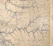
-Ki- Hero Member Joined Feb 12, 2009 Messages 642 Reaction score 583 Golden Thread 0 Location EASTERN KENTUCKY Detector(s) used MD & Handwand "CaveHunter"Hiker" SonyDigital SLR Oct 2, 2009 Thread Owner #1 Pioneer map of Ky 1770's This map shows Lick cr on the red river a creek supposedly named by John Swift, and also shows the warriors path that ran up through station camp creek and the wilderness road that ran up through blue licks on the map... Attachments M4.webp 134.2 KB · Views: 2,398
Pioneer map of Ky 1770's This map shows Lick cr on the red river a creek supposedly named by John Swift, and also shows the warriors path that ran up through station camp creek and the wilderness road that ran up through blue licks on the map...
-Ki- Hero Member Joined Feb 12, 2009 Messages 642 Reaction score 583 Golden Thread 0 Location EASTERN KENTUCKY Detector(s) used MD & Handwand "CaveHunter"Hiker" SonyDigital SLR Mar 29, 2010 Thread Owner #2 Re: Pioneer map of Ky 1770's
Beercanman Full Member Joined Feb 26, 2011 Messages 243 Reaction score 128 Golden Thread 0 Location Lexington, Kentucky Feb 1, 2013 #3 Thanks!
Dirt.Is.Good.4U Full Member Joined Nov 27, 2012 Messages 103 Reaction score 16 Golden Thread 0 Location Nicholasville, KY Detector(s) used Minelab e-Trac, Garrett AT Pro, White's Prizm III Primary Interest: Relic Hunting Feb 2, 2013 #4