Possible Bell

franklin

Gold Member
Jun 1, 2012
5,036
7,168
Detector(s) used
Garrett ADS-7X, Fisher Two Box M-Scope, Mother Lode Locator, Dowsing Model 20 Electroscope, White's TM808, White's TM900, Inground Scanners
Primary Interest:
All Treasure Hunting
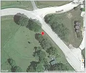
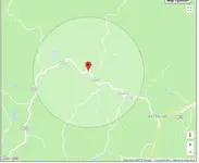
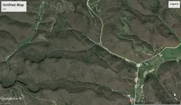
I just thought it was great just to find it and to get a look at it. Especially since they said it was already gone. In someone's yard like that in 2001 or 2009 just maybe it is still there. It is a historical marker anyway and I do not think they would have removed or crushed it into gravel?
 

KY Hiker

Bronze Member
Oct 28, 2014
1,537
3,220
North Central Kentucky
Detector(s) used
Whites
Primary Interest:
All Treasure Hunting
Yes I agree. They wouldn't crush it into gravel, sandstone would break up into powder anyway, limestone is typically used for road and driveway rock. But with all the oil production that was going on there back in the day, there is no telling. A lot of heavy equipment being used. This is a wild guess... if its too small and in the wrong place...this is someone's standing rock in their yard but not "the standing rock". Or the description given was way off and the county line has moved...? I have seen landscape boulders and flat standing stones along driveways around here much larger than this, they are limestone though.
 

Last edited:

franklin

Gold Member
Jun 1, 2012
5,036
7,168
Detector(s) used
Garrett ADS-7X, Fisher Two Box M-Scope, Mother Lode Locator, Dowsing Model 20 Electroscope, White's TM808, White's TM900, Inground Scanners
Primary Interest:
All Treasure Hunting
Yes but when they made Lee County, they took parts of Wolfe, Owsley, Estill and Powell Counties. So they could have removed the corner from the Standing Rock. I tried to contact the fellow that posted the photograph, he would know, but I have not gotten a reply. Try to contact him. He had that photograph up since 2001 but does not say when the photograph was taken or if it was still there?
 

KY Hiker

Bronze Member
Oct 28, 2014
1,537
3,220
North Central Kentucky
Detector(s) used
Whites
Primary Interest:
All Treasure Hunting
Yes but when they made Lee County, they took parts of Wolfe, Owsley, Estill and Powell Counties. So they could have removed the corner from the Standing Rock. I tried to contact the fellow that posted the photograph, he would know, but I have not gotten a reply. Try to contact him. He had that photograph up since 2001 but does not say when the photograph was taken or if it was still there?

Your post with the text says made Wolfe out of Powell... no mention of Lee? Not sure why a place would be called Standing Rock if the rock is a mile down the road in a town called Leeco though? It could be they were misled when they snapped that picture, a geology group from UK thinking that was the rock or told so. Don't know but I am feeling like I'm down another rabbit hole! I might have to go to Campton Courthouse to get an answer.
 

Last edited:

KY Hiker

Bronze Member
Oct 28, 2014
1,537
3,220
North Central Kentucky
Detector(s) used
Whites
Primary Interest:
All Treasure Hunting
Maybe this will help? View attachment 1627702

It is in one of the corners of a survey made for Wolfe County.

No mention of Lee County.... Standing Rock entry Journal of the House of the General Assembly of the Commonwealth of Kentuc.png

Funny that I thought it might be a peculiar rock or a monument rock...turns out it is a monument rock, like a survey monument at one time.
 

Last edited:

franklin

Gold Member
Jun 1, 2012
5,036
7,168
Detector(s) used
Garrett ADS-7X, Fisher Two Box M-Scope, Mother Lode Locator, Dowsing Model 20 Electroscope, White's TM808, White's TM900, Inground Scanners
Primary Interest:
All Treasure Hunting
No mention of Lee County.... View attachment 1628367

Funny that I thought it might be a peculiar rock or a monument rock...turns out it is a monument rock, like a survey monument at one time.

That copy was 1860 when Wolfe County was formed. Lee County was not formed until 1870.
 

OP
OP
1320

1320

Silver Member
Dec 10, 2004
3,436
2,308
East Central Kentucky
Looks like someone took the initiative to post on the Wolfe county forum and got an answer. Thanks!

Standing Rock Picture/Location - Discussion on Topix

"wow, I don't think I'll get help from that!"

"But I'm the kind of person who likes to open all the doors even if someone tells me there is a brick wall behind it...I need to see for myself."

You're welcome. I made the post on Topix. I hope you'll consider Topix as a door to open in the future.
 

OP
OP
1320

1320

Silver Member
Dec 10, 2004
3,436
2,308
East Central Kentucky
Your post with the text says made Wolfe out of Powell... no mention of Lee? Not sure why a place would be called Standing Rock if the rock is a mile down the road in a town called Leeco though? It could be they were misled when they snapped that picture, a geology group from UK thinking that was the rock or told so. Don't know but I am feeling like I'm down another rabbit hole! I might have to go to Campton Courthouse to get an answer.

Leeco = Lee County
 

KY Hiker

Bronze Member
Oct 28, 2014
1,537
3,220
North Central Kentucky
Detector(s) used
Whites
Primary Interest:
All Treasure Hunting
"wow, I don't think I'll get help from that!"

"But I'm the kind of person who likes to open all the doors even if someone tells me there is a brick wall behind it...I need to see for myself."

You're welcome. I made the post on Topix. I hope you'll consider Topix as a door to open in the future.

Much of what I saw posted was trash talk, so I dismissed it.
 

boomer

Sr. Member
Jul 8, 2003
487
523
kentucky
Detector(s) used
army all terrain
:usflag:1320: your first picture showing swift map with 6 and 6A. found parts of a path going up right side of ridge to top. number 6 is where suiters branch road runs up hollow. if you walk on right path you will see cliffs on top of ridge, go south to end of cliff, look hard for a bell cut in cliff at waist high. you should see a cut line running across center pointing downward about 20 degrees toward north. I believed I was to look for path or maybe a cave opening or pile of rocks. I know it was pointing toward a small hill just north of suiters road and ridge. Note: the way up is halfway up suiters rd. and dam steep and hard. the dotted line is correct, you must follow it to bell. because it was end of summer, I could not see anything because of trees and brush. I think they put this path there because you could see the bell from the top of the ridge. if you are walking around that small rise or small hill you would never see any form of bell. look at bottom of first picture, that is where beaver creek runs past suiters road and that is also where route 36 runs into frenchburg. just past suiters rd, 36 turns left and runs towards salt lick ky. go north on 36 and you will come to a bend. look for drain that heads east. that is lower part of bell and part of the lower part of suiters ridge. go past bend and you come to cooper branch road, go up cooper rd. and on left beside road you should see a drain about 5 feet deep, that is left side of bell. I have photo of that section of map. I hope it works? anyway the drains tie together to form bell at bottom of ridge. Spanish and French would want you to look for opening on hill. something hiding on same. I keep looking at the bell tie on top. to me it seem to say gateway to something below. if photo does not work. go to google earth and use historical settings to get best picture of area.
 

Attachments

  • bell.jpg
    bell.jpg
    160.5 KB · Views: 136

Top Member Reactions

Users who are viewing this thread

Top