Possible Bell

boomer

Sr. Member
Jul 8, 2003
487
523
kentucky
Detector(s) used
army all terrain

Attachments

  • summer bell.jpg
    summer bell.jpg
    199.2 KB · Views: 132
OP
OP
1320

1320

Silver Member
Dec 10, 2004
3,436
2,308
East Central Kentucky
:usflag:
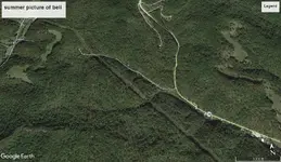
1320: your first picture showing swift map with 6 and 6A. found parts of a path going up right side of ridge to top. number 6 is where suiters branch road runs up hollow. if you walk on right path you will see cliffs on top of ridge, go south to end of cliff, look hard for a bell cut in cliff at waist high. you should see a cut line running across center pointing downward about 20 degrees toward north. I believed I was to look for path or maybe a cave opening or pile of rocks. I know it was pointing toward a small hill just north of suiters road and ridge. Note: the way up is halfway up suiters rd. and dam steep and hard. the dotted line is correct, you must follow it to bell. because it was end of summer, I could not see anything because of trees and brush. I think they put this path there because you could see the bell from the top of the ridge. if you are walking around that small rise or small hill you would never see any form of bell. look at bottom of first picture, that is where beaver creek runs past suiters road and that is also where route 36 runs into frenchburg. just past suiters rd, 36 turns left and runs towards salt lick ky. go north on 36 and you will come to a bend. look for drain that heads east. that is lower part of bell and part of the lower part of suiters ridge. go past bend and you come to cooper branch road, go up cooper rd. and on left beside road you should see a drain about 5 feet deep, that is left side of bell. I have photo of that section of map. I hope it works? anyway the drains tie together to form bell at bottom of ridge. Spanish and French would want you to look for opening on hill. something hiding on same. I keep looking at the bell tie on top. to me it seem to say gateway to something below. if photo does not work. go to google earth and use historical settings to get best picture of area.

On your map Cooper Branch Road is locally known as Suiter's Holler/Branch, that's where the original homestead is. Your Google map is showing Suiter's branch in an entirely different area. Are you refering to the branch at the bottom of Craig Hill? It's on the left, traveling 36 towards Owingsville, just before you begin ascending the hill.

I'm still confused on what the bell is? Is it a rock formation or do the trails represent the shape of a bell? The rock formation picture that I posted looks like a bell and it sits at the top of Craig Hill, plain as day.
 

rgb1

Sr. Member
Nov 24, 2013
295
769
s.w. Ohio
Detector(s) used
2 whites 1 garett
Primary Interest:
All Treasure Hunting
bell

what does bell have to do with swift ledgen guess i missed it
 

KY Hiker

Bronze Member
Oct 28, 2014
1,537
3,220
North Central Kentucky
Detector(s) used
Whites
Primary Interest:
All Treasure Hunting
On your map Cooper Branch Road is locally known as Suiter's Holler/Branch, that's where the original homestead is. Your Google map is showing Suiter's branch in an entirely different area. Are you refering to the branch at the bottom of Craig Hill? It's on the left, traveling 36 towards Owingsville, just before you begin ascending the hill.

I'm still confused on what the bell is? Is it a rock formation or do the trails represent the shape of a bell? The rock formation picture that I posted looks like a bell and it sits at the top of Craig Hill, plain as day.


Here is the only bell shape I see in the area. I'm not sure how they could have seen it from the ground, even if on a ridge.
Inkedsummer bell_LI.jpg

Inkedwinter bell_LI.jpg
 

Last edited:
OP
OP
1320

1320

Silver Member
Dec 10, 2004
3,436
2,308
East Central Kentucky
Here is the only bell shape I see in the area. I'm not sure how they could have seen it from the ground, even if on a ridge.
View attachment 1630723

View attachment 1630725

"look hard for a bell cut in cliff at waist high"

" you could see the bell from the top of the ridge"

I'm not real certain what the "bell" is supposed to be, I'm confused. The rock formation that I posted is right there and it looks more like a bell than anything I can interpret from the drawings.
 

Attachments

  • newbell.jpg
    newbell.jpg
    200.5 KB · Views: 127
  • bbell.jpg
    bbell.jpg
    200.9 KB · Views: 120
Last edited:

boomer

Sr. Member
Jul 8, 2003
487
523
kentucky
Detector(s) used
army all terrain
when trying to work out this type of sign, forget everything about the year 2018 and revert back to say 1760 you are alone with a few men and you must look at the land in there way of seeing it. if they were going to be heading back to civilization. what way is going to help find the best spot for showing something. hmmm? notice the map maker is saying go up this hollow to a halfway point than go right up ridge and you can see outline of our bell. notice he stopped the path line before the bell and the dotted line is a little to the right of center of bell. another clue. do any of you use magnifier. its an add on from Microsoft. on google earth you can zoom in, than use magnifier to get way down to just above ground level and just walk along searching its vary good. where the dotted line stopped just before bell, on google earth it shows a cliff line where the dotted line is and the cliff line is off to right of center. odd they match. why? maybe your suppose to look around cliff just below, or the clapper at bottom center of bell, which would be that small drain running off low center of bell. this is important because they made this to show something around that hill or cliff line. if luck holds a 4x4 should not have any problem running on or around that place. this I wonder about that ring on top its off of center not centered on top. could it mean look for opening to cave or something buried near top of bell?
there are four old maps that have a bell on them. it is an important symbol. but what???
 

Last edited:

KY Hiker

Bronze Member
Oct 28, 2014
1,537
3,220
North Central Kentucky
Detector(s) used
Whites
Primary Interest:
All Treasure Hunting
The people of that age had much more imagination than we do today, they never had video screens or cameras. It can be difficult to get into their way of 'seeing' things from our time and lazy minds. So the bell is a carving, a ridge or a rock ? Sorry, I'm not following well on this one.
 

KY Hiker

Bronze Member
Oct 28, 2014
1,537
3,220
North Central Kentucky
Detector(s) used
Whites
Primary Interest:
All Treasure Hunting
Well, there is this Bell named drain which contains a fault of geological significance. People always stop along the road here to take pictures of the falls and fill up their water bottles. I have been told there is trace radioactive material found here as well. FYI it is about 1.5 miles as the crow flys from Indian Stairway.
The drain is in the center of the map linked...

https://www.topoquest.com/map.php?l...3&zoom=8&map=auto&coord=d&mode=zoomout&size=m


http://www.uky.edu/KGS/minerals/im_uranium.php

"...Another occurrence of uranium is at Bell Falls in Menifee County. This is in the Red River Gorge and Daniel Boone National Forest and was investigated in 1970-71. No extensive work has been done on this deposit, but it is located in an unnamed coarse sandstone and conglomerate containing coal fragments at the base of the Breathitt formation along the Red River. Analysis by the Atomic Energy Commission in Hutchins (1971) confirmed the anomalous nature of this deposit and reported numerous other uranium anomalies in eastern Kentucky. Another uranium occurrence is in an unnamed limonitic sandstone in Catlettsburg in Boyd County, confirmed by a Southern Interstate Nuclear Board project in 1953.

These sandstone occurrences in eastern Kentucky could fit the classic geologic model for sedimentary uranium roll front deposits, similar to deposits in Colorado and Wyoming. The origin of these is probably related to deeper groundwater in eastern Kentucky, which had been in contact with subsurface black shale, migrated upward, and formed a reducing environment to deposit the uranium. "

http://ed-henson.blogspot.com/2011/02/strange-case-of-bell-falls.html
 

Last edited:

Top Member Reactions

Users who are viewing this thread

Top