River Weirs

Old Dude

Gold Member
Joined
Feb 20, 2013
Messages
8,799
Reaction score
9,850
Golden Thread
0
Location
Luzerne County, Pa
🏆 Honorable Mentions:
2
Detector(s) used
Fisher F75, Garrett ATPro, Garrett GTAx 500
Primary Interest:
Metal Detecting
See the "V" in this Google Earth screenshot?
ypa6e9ut.jpg

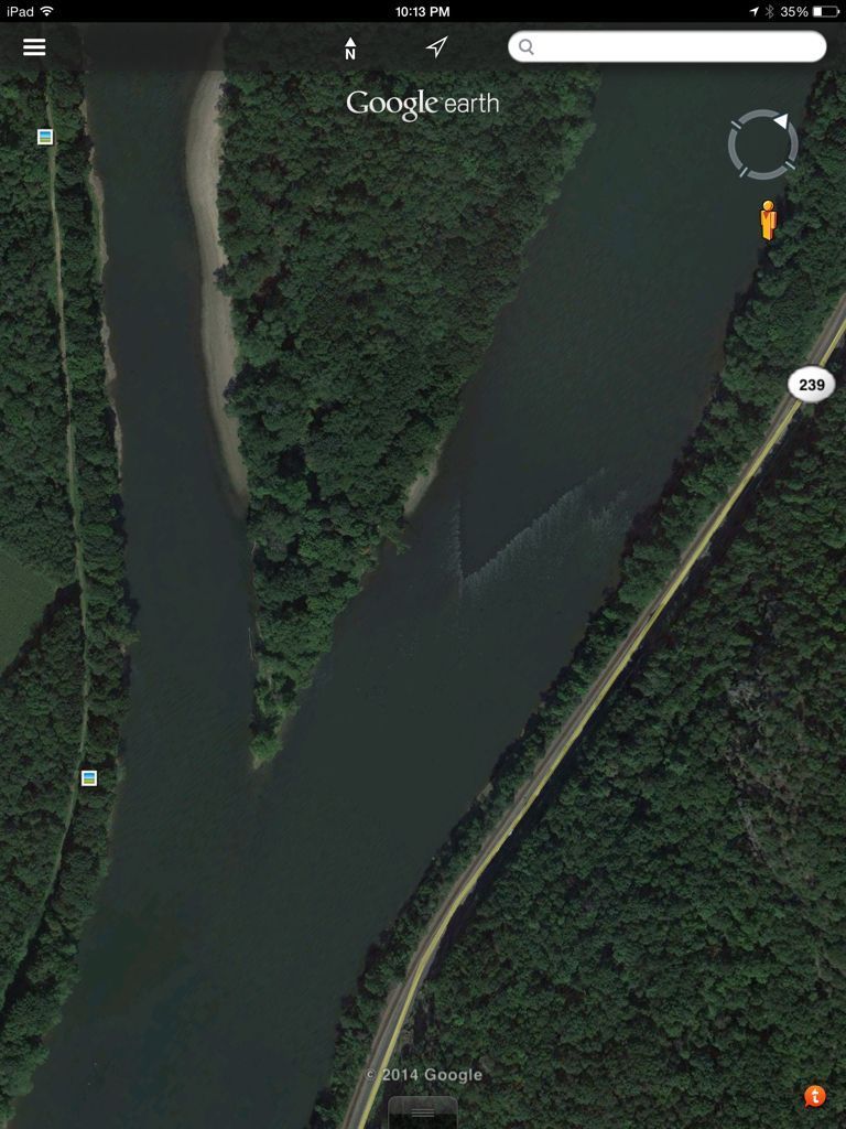
These are something man has created out of necessity to take advantage of the bounty we have been given. They are eel walls or weirs. Fishing peoples worldwide have used similar structures for centuries. A trap of some sort would be placed at the point of the "V" to capture the American freshwater eel in this instance on the Susquehanna River. My fellow detecting friend and Native American enthusiast Wyoming Valley Relics tells me the indigenous peoples of this area would "herd" fish into these weirs and catch them perhaps in nets or baskets. I have read that around the turn of the 20th century, many local churches would hold eel suppers. These weirs provided the star of the meal.
 

You might also be interested to know that there is a trail tree that marks this site ...

weir_pointer.jpg
 

Good info and nice pics
 

There's where water-proof comes into play...We were all made drip dry!:laughing7:
 

I remember a documentary of a guy that caught and smoked eels. A Down Mainer. Seems they went for $20/lb. He had to compete with a bald eagle that would raid his catch. Tastes like snake?
In the documentary, the guy didn't have to do much. His design was such that the eels would swim in and be trapped. He would come back when he figured it was time. The guy was an engineer so his design might have had his stamp on it.
 

Last edited:
Very interesting post and historical info Old Dude. :thumbsup:
I'd be inclined to detect in the 'V' area in the picture.
Dave

"The Susquehanna River is one of the oldest existing rivers in the world, being dated as 320—340 Mya, older than the mountain ridges through which it flows. These ridges resulted from the Alleghenian orogeny uplift events, when Africa (as part of Gondwana) slammed into the Northern part of EurAmerica). The Susquehanna basin reaches its ultimate outflow in the Chesapeake Bay. It was well established in the flat tidelands of eastern North America during the Mesozoic era about 252 to 66 million years ago. This is the same period when the Hudson, Delaware and Potomac rivers were established.

"Susquehanna" comes from the Len'api (or Delaware Indian) term Sisa'we'hak'hanna, which means "Oyster River." Oyster beds were widespread in the bay near the mouth of the river, which the Lenape farmed, leaving oyster shell middens. Peoples of the mid-Atlantic Coast included coastal peoples who spoke Algonquian languages, such as the Len'api (whose bands spoke three dialects of Lenape), and Iroquoian languages-speaking peoples of the interior, such as the Eroni and the Five Nations of the Iroquois. The English of Pennsylvania referred to the Eroni people of Conestoga as "Susquehannocks" or "Susquehannock Indians," a name derived from the Lenape term. In addition, John Smith of Jamestown, Virginia, labeled their settlement as "Sasquesahanough" on his 1612 map when he explored the upper Chesapeake Bay area. In Virginia and other southern colonies, Siouan-speaking tribes constituted a third major language family, with their peoples occupying much of the middle areas of the interior. Iroquoian speakers, such as the Cherokee and Tuscarora, generally occupied areas to the interior near the Piedmont and foothills.

In the 1670s the Conestoga, or Susquehannock people, succumbed to Iroquois conquest by the powerful Five Nations based in present-day New York, and assimilated with them. In the aftermath, the Iroquois resettled some of the semi-tributary Lenape in this area, as it was near the western boundary of the Lenape's former territory, known as Lenapehoking. The river has also played an important role throughout the history of the United States. In the 18th century, William Penn, the founder of the Pennsylvania Colony, negotiated with the Lenape to allow white settlement in the area between the Delaware River and the Susquehanna, which was part of Lenape territory."
 

Attachments

  • Gen_Clinton's_Dam_Monument.jpg
    Gen_Clinton's_Dam_Monument.jpg
    397.7 KB · Views: 93

Top Member Reactions

Users who are viewing this thread

Back
Top