What's new

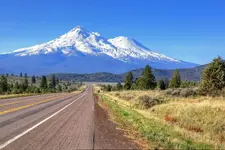
Roadside Pic ( Mt. Shasta )

ronwoodcraft

Bronze Member
Joined
Jul 14, 2007
Messages
2,348
Reaction score
8,450
Golden Thread
0
Location
Idaho
Drive this road ( Hwy 97 ) all the time and get used to seeing this. Thought someone else might like to see it, so I pulled over and took a snapshot.
 

Attachments

  • 007_7_77_MTSHASTA.webp
    007_7_77_MTSHASTA.webp
    211 KB · Views: 136
photo_picture.gif
Nice photograph Ron! Thanks for sharing...
 
I've not gazed upon that landmark in a long time. Nice to see it's still there.
 
That sure is a beautiful picture...wow...like a painting...thanks for sharing it!
 
Please post more of the area when you can. It has been many years since I have been there.
 
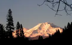
Shasta Sunset at Ballpark.webp
From the south side of Mt. Shasta looking north (the other side) from the town of Dunsmuir CA
 
Click on your original picture (top of this page,) and you notice the "gravel" is red? Yes - it is volcanic cinders - pavement is red in places and the cinders spread on ice and snow are red. Lava flow at the next curve that Highway 97 goes around, heading towards Weed CA (yes that is the name of the town, named after Abner Weed) and I-5. There is potential for treasure hunting on the original railroad grade but - it is now all private property, and access would be difficult. That grade was abandoned in the 1920's. Lots of rattle snakes, loose cattle (county is open range - fences are to keep cattle out, not in), and dead deer along the roads from all sorts of vehicles colliding with them. Did I mention bears?
 
Awesome photo! :icon_thumleft:!
 

Users who are viewing this thread

Back
Top Bottom