Springfield
Silver Member
- Joined
- Apr 19, 2003
- Messages
- 2,850
- Reaction score
- 1,388
- Golden Thread
- 0
- Location
- New Mexico
- Detector(s) used
- BS
the blindbowman said:humans talk a lot of sh-- ! ...
Yes, indeedy they do.
the blindbowman said:humans talk a lot of sh-- ! ...
the blindbowman said:humans talk a lot of sh-- !
your opioions are your own . and i hope others enjoy your input even if you have forgotten one fact ..
what if i am right !
it dose not matter if you agre or even under stand the data or the legends true path .. the fact is i could still be right ..!
IMHO the 4 bells of tayopa do show up in the codex
a water fall get real ...
he said , Fingers of God ,,
it was the only known discriptive wording to the somberro mine
did you ever wonder why waltz told dick holmes , threw the saddle .. and not over the saddle .. it dose make a lot of sence when you under stand the small details .. but this is not about the details or the legends is it ...
fact ,i am correct and nothing you can say or do will change that ...
i have requesed a premit and untill the NFS has proven i am right or wrong ,the request stands and no one will be able to make any clams at that site .. you are so bent on no one finding these legends ..other then your self ..
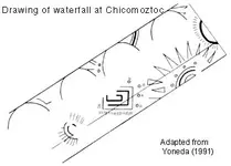
as i said ,watch and learn ...site 4 is chicomoztoc ...
go ahead messure any part of the simbolic drawing compair the scale to the geological hill .. i am right .. this is chicomoztoc . and no matter what insaults you make to me presonally .. you will be the fool when this is over ...
the fact remains i will be proven right ..this is chicomoztoc
stay safe stay free
the blindbowman said:i do find it funny how you over look the details and agree with only your own opioions right or wrong ,...lol
how one acount has waltz killing the prealta for the mine ? and takeing the mine by force yet here is the somberro mine and a mine own by the prealta familiy that dose relate dirrectly to one of waltz's acounts if not all of them ..
i have been to this mine shaft and you dont know it yet but there is evidence to suport what i am saying . but i am only one man, i could not move the mine shaft any more then anyone else could .. and what if , with all your ego and opioions you are all wrong and i am in fact right ..
none of these legends have been solved and documented as of yet ...
post any artifact related to any of these legends , anyone of you ,willing to step up and post a picture of anything from chicomoztoc, tayopa ,the somberro mine or the LDM ...
come on step up .. lets see what evidence you have ...i have a lot more you dont know about and you may be way over your heads and dont even know it yet ....lol
the blindbowman said:i have one more piont to make .
i am sorry ,
very sorry.
i did not preceive how navigationally illiterate the human race is ...
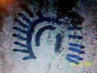
somehiker said:The magnifier tool of Fastone distorts it quite a bit,unfortunately,but the resemblance to the image on the map is still evident.Curious place this.
Regards:SH.
you would have to under stand this culture warshiped the lunar and the solar , a balance between to realities ..somehiker said:Hi BB:
I suspect that the real reason that most of your photos are of such poor quality is that they are low resolution or enlarged versions of web cam/digital cam pics of whatever you could find online and display on your computer screen.I recently used a similar technique to obtain some stills from an old vhs tape for a technical manual,but found that a 35mm film camera gave better results.
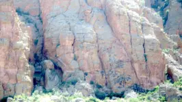
Here is a real photo,and perhaps you can explain what the image on the rock at the bottom of the waterfall(bottom left) might represent.I will also post a view of the MC2 map for comparison.
Regards:SH.
you are so bent on no one finding these legends ..other then your self ..

and no matter what insaults you make to me presonally .. you will be the fool when this is over ...
how one acount has waltz killing the prealta for the mine ?
and what if , with all your ego and opioions you are all wrong and i am in fact right ..
tenochtitlan was said to have been surounded by water thats when i realized the totem was showing the fall of the chicomoztoc culture .

yes i am a senitive preson and i often over react to insaulting remarks

Peerless67 said:QUOTE BB
"we could learn so much from this site ....
it is way beyond the value of any treasure trove
the evidence at this site could some day save the human race from extinction!"
QUOTE BB
"after the football game i will try to post some more pics ..."
 Actually lot's of navigation Duh's.
the legends of chicomoztoc are ancient we just dont know how old chicomoztoc real is . if its older then the clovis site of 13,500bc . this may be the strong hold that helped save the human race from the black matt era . noteing the location would reflect much of the outer weather from the plans around this mt range.. dont fool your selfs this site has some very unique geology qualities .rochha said:BB
" the evidence at this site could some day save the human race from extinction! "
Could you elaborate on this statement a little?
Respectfully,
Rochha