Treasure Signs and Symbols 101

Shortstack said:
After reading Kenworthy's books back in the early 90s, I began noticing the large trail signs that could be seen from the interstate highways. ( I was a truck driver at the time) It was surprising how many can be seen in New Mexico from the "big roads". If someone is driving these roads and spots a marker, they should note the milemarker and return there when they have time to followup. Or, use a GPS to note the location, then check topos of the area to learn the lay of the land and find the backroads and trails before "going in". There are large markers to be seen in Utah, Arizona, west Texas, and the southern half of California, too. Just a thought.
In my opinion these are more like the modern equivelant of the interstate highway sign, dosent neccisarrily denote anything more than the route to travel when crossing the continent. there are literaly hundreds of those things in the county i live in, possibly near a thousand. the smaller ones that are difficult to see might be worth looking into though. i spot four or five a day easy out moving iron, but there are so many of them it boggles the mind
 

heres some picks from the old location today while i was rigging down
 

Attachments

  • 001a1.jpg
    001a1.jpg
    80.8 KB · Views: 1,928
  • 003a1.jpg
    003a1.jpg
    109.8 KB · Views: 1,954
  • 005a1.jpg
    005a1.jpg
    112.7 KB · Views: 1,940
  • 008a1.jpg
    008a1.jpg
    122.8 KB · Views: 1,906
by the way, pics 1 and three are of angel peak, a touristy type place. the pics are taken from the badlands below Angel Peak pic 1 is about 1 mile away on the location, three was a few miles down the road on my way out to the highway. can anyone tell the difference between the man made "markers" and the similar looking naturally occouring ones?
 

rigmover,
Thanks for posting the pics!
you commented,...
can anyone tell the difference between the man made "markers" and the similar looking naturally occurring ones?

At the risk of sounding like a broken record [ yea too late for that now!] it is Confirmation! Confirmation! Confirmation!

The is why they made these confirmation marks, so you tell the difference.
DSC_9735cropped_1_1_1.jpg
(c)2009 copyright-all rights reserved.
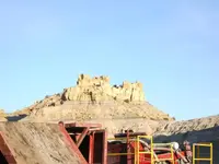
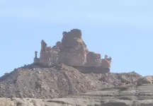
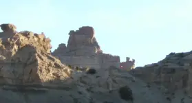
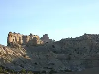
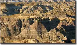
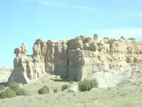
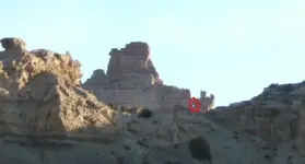
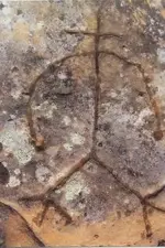
The Mighty Owl, cut from stone, 'holding' a heart rock telling you that you are confirmed and their is a Cache nearby
kinda a double whammy sign!

1. Hoyo
2. Human Faces
3. Letters
4. Numbers
5. Animal Faces
6. Geometric shapes
7. Shadow signs that make up the above

It takes time, you really cant rush this part of the program. Take your pics one at at time and look for the above items.
Crawl over each rock until you can see every nook and cranny. If you find nothing after due diligence, then you have
eliminated that part of the country side. Move on to the next pic. Normally I look for the Hoyo when something catches
my eye..then I take a pic and do like the above! This cuts the time down considerably. As you go you can learn to take pics once you have seen at least a hoyo ..narrowing down the field work/

Even after 20+ years in the field, you still cant see and verify a Monument with out the camera, and the computer..
that how well hidden these marks are - they are made to blend in with background camo of mother nature.

Hidden in plain site
have fun, hope this helps
rangler

Thom Thank You!

Notice!
This thread has had to be extensively edited due to certain members'
inappropriate, inconsiderate, and irresponsible conduct.
It is quite likely that more direct corrective measures will be taken if this problem persists.
Also, please keep the following in mind when posting:
• Do not quote posts unnecessarily— and especially not lengthy posts in their entirety.
• Do not post off-topic comments, quotes, other text, or images...PBK
 

Correct Thom
and It looks like it is a broad head arrow pointing to the right!
I will bet you a cold adult beverage that a trial goes thru pass
right here..and to miss this would take you a long way out of
your way..
A quick overview would say Trail maker as opposed to Alpha..
However some close ups of the boulder would tell you this
if nothing else is found but this hoyo then trail marker.
hope this helps :thumbsup:
rangler
 

Old Dog said:
Jason,
Can you tell me more about pic #1 ?
Do I see an alpa hoyo here?
i dont know about alpha. isocolese triangle long leg pointing down and to the left.here is some info about angel peak, then the unmolested pic that i took yesterday

The Angel Peak National Recreation Site is more than 10,000 acres of scenic badlands about 15 miles southeast of Bloomfield in San Juan County. Looking at these photos you can tell that this is a heavily eroded, old ocean and river bottom landscape. The area started forming about 60 million years ago as the ancient waterflows piled up layers of mud and sand that turned to stone over time. The fantastic shapes have been carved in the layered, multi-colored sandstone, siltstone and mudstone by the action of wind, rain and frost. The banded colors exposed in the deep sculpted fingers at the base of Angel Peak itself (6,988') can only be seen by those who make the journey around the rim of the badlands.

A lot of the mudstone slopes below the sandstone-capped mesas are materials of the Nacimiento Formation (the spire of Angel Peak is of the San Jose Formation, a harder sandstone laid down several million years later). The Nacimiento Formation is composed of hundreds of feet of rock, sand and other materials washed here by high energy rivers flowing down from the Rocky Mountains and meeting the Inland Cretaceous Sea in this area. These rivers were flowing from the high grasslands, swamps, marshes, lakes, and forests further north where the great mammal explosion was happening, after the mass extinction of the dinosaurs. The mudstone, siltstone and sandstone layers here at Angel Peak are still eroding, and with each rainfall, new mammalian fossils are exposed. There's also layers of petrified wood coming out of the canyon walls. We call this a "badlands" but for permitted paleontologists, this area is a vast treasure trove cataloguing the early evolution of mammals.
 

Attachments

  • 001a2.jpg
    001a2.jpg
    97.8 KB · Views: 1,881
here are some stock photos of the area
 

Attachments

  • 01h.jpg
    01h.jpg
    35.1 KB · Views: 1,790
  • 01g.jpg
    01g.jpg
    22.8 KB · Views: 1,775
  • 01e.jpg
    01e.jpg
    34.5 KB · Views: 1,767
  • 01d.jpg
    01d.jpg
    28.2 KB · Views: 1,779
  • 01b.jpg
    01b.jpg
    32.5 KB · Views: 1,796
  • 01a.jpg
    01a.jpg
    30 KB · Views: 1,794
rangler said:
rigmover,
Thanks for posting the pics!
you commented,...
can anyone tell the difference between the man made "markers" and the similar looking naturally occurring ones?
At the risk of sounding like a broken record [ yea too late for that now!] it is Confirmation! Confirmation! Confirmation!
The is why they made these confirmation marks, so you tell the difference.

i was simply eluding to the fact that in pic 4 there used to be a rock in that hole (there didnt used to be a hole). it fell over on the other side after a turd floater rainstorm year before last. the band of dirt they are sitting on is only about two and a half feet wide at the top.
from the pavement to the bottom of the badlands is about three miles then about seven to where i took the pics at. in that seven miles i swear i can see "stuff" in every single rock thats sitting on top of a dirt mound. thats not really practical cause that would be hundreds of "confimation" marks in a bowl shaped canyon that the only exit is the way you came in.im just trying to figure out why these s/s are here cause this whole area is aboot five miles south of the Main spanish trail,Largo.
 

Jason,
you said...
"I was simply eluding to the fact that in pic 4 there used to be a rock in that hole (there didnt used to be a hole). it fell over on the other side after a turd floater rainstorm year before last. the band of dirt they are sitting on is only about two and a half feet wide at the top."

I understand your comment, and I believe what you say is true, the only thing I want to add,is..the hoyo is too perfect for it to be designed by a flood..a symmetrical broad head arrow..is one in a billion by mother nature...now that is not to
say it didnt or couldn't be, but the odds..you know? Another aspect is the angle, lots and lots of hoyo are designed to be seen from only a narrow point of view, meaning that boulder that fell could have been blocking your view from that vantage point, meant to hide it from that direction? Then when the boulder fell it lost part of its camo...
DSC_9735cropped_1_1.jpg
Here is a arrow hoyo, pointing to the critters just at the right, can you see THEM>?
The final point I have is that the Arrow head is pointing at the END of that ridge line, so that is more than just an accident, I think...I may be wrong, but if you hike back there, I think you will see a pass or a drop in elevation that
allows you to move thru this range of mountains. A quick check with an online topo will tell you, if your so inclined
hope this helps
rangler
 

Rangler Wrote " Dign was the Scapegoat, and the Sacrificial Lamb at the same time..so while Dign left
us some awesome original data, he also VOLUNTARY left as a demonstration of his disgust
as a from of protest.So lets pay back Dign for his data, by NOT getting booted ourselves. "

Rangler Sir, Do you know how to get ahold of Stilldign. Maybe he Might reconsider.
 

rigmover2307 said:
In my opinion these are more like the modern equivalent of the interstate highway sign, doesn't necessarily denote anything more than the route to travel when crossing the continent. there are literally hundreds of those things in the county i live in, possibly near a thousand. the smaller ones that are difficult to see might be worth looking into though. i spot four or five a day easy out moving iron, but there are so many of them it boggles the mind

Thanks for the reply, rigmover. Looking for those markers sure helped to make the time pass while going through some of those wide open stretches of road.
Wouldn't the "money" markers be keyed into these main trail markers? Or have you found that one doesn't necessarily relate to the other? Money and treasures are one thing, but looking at the pure SCALE of most of these markers and signs and thinking of the amount of WORK that went into each one is were the real fascination sets in. Those folks were some SERIOUS worker bees. ( in all due respect!! )

I hope my questions and comments don't distract you, rangler,old dog, Victorio, et al, too much. This information is absolutely fascinating. :icon_thumright: :icon_thumleft:
 

rangler said:
I understand your comment, and I believe what you say is true, the only thing I want to add,is..the hoyo is too perfect for it to be designed by a flood..a symmetrical broad head arrow..is one in a billion by mother nature...now that is not to
say it didnt or couldn't be, but the odds..you know? Another aspect is the angle, lots and lots of hoyo are designed to be seen from only a narrow point of view, meaning that boulder that fell could have been blocking your view from that vantage point, meant to hide it from that direction? Then when the boulder fell it lost part of its camo..

were talking about two different pic's the one you are referring to is definatly a marker with a perfect hoyo, the one i am refering to as recently created by a rainstorm has no hoyo and is this pic below.
 

Attachments

  • 008a1.jpg
    008a1.jpg
    122.8 KB · Views: 1,852
  • 008a1.jpg
    008a1.jpg
    122.8 KB · Views: 1,785
Old Dog said:
I was refering to this one.

I circled it a little brighter

Oh i definatly noticed that one, that is a major landmark around here, and iv never seen the trail marker on top till the other day. course that was the farthest into the badlands i had ever been. i took that pic from approx 1 mile away. you cant see it from up on top at the recreation area, and you cant see it from the main spanish trail, the following pics show where the main route of travel south to north (Largo canyon)intersects the San juan river and the trail takes a north westerly direction. the yellow circle is Angel peak as the Spanish would have seen it in passing. durring the colonization period, thats a whole different ball game.
 

Attachments

  • 003b.jpg
    003b.jpg
    133.8 KB · Views: 1,778
  • 008b.jpg
    008b.jpg
    135.9 KB · Views: 1,742
how do you know if you have a turnaround#3 or a 3rd point of a triangle #3 ? thanks brent
 

Attachments

  • resized.jpg
    resized.jpg
    17.4 KB · Views: 3,667

Top Member Reactions

Users who are viewing this thread

Back
Top