What's new

Two gold mines detected

TerryC

Gold Member
Joined
Jun 26, 2008
Messages
7,855
Reaction score
11,225
Golden Thread
0
Location
Yarnell, AZ
Detector(s) used
Ace 250 (2), Ace 300, Gold Bug 2, Tesoro Cortes, Garrett Sea Hunter, Whites TDI SL SE, Fisher Impulse 8, Minelab Monster 1000, Minelab CTX3030, Falcon MD20, Garrett Pro-pointer, Calvin Bunker digger.
Primary Interest:
Metal Detecting
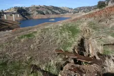
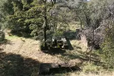
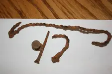
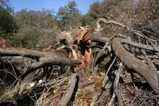
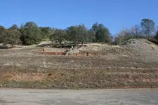
My brother, TimC and myself, detected the Gold mines near Hwy 49 at New Melones Reservoir. Minimal success. The first pic shows the foundation of GM1, visible from the 49 bridge across the reservoir (I always thought this was a bridge foundation). Second pic shows its shaft. Pic 3 shows GM2 with TimC standing in its shaft... he is in the middle of the pic, just above the center. This GM is above #1, about 100 yards into the woods. Pic 4 is my finds. A hand-wound iron wire "cordage", a brass rivet from a tool, and a square nail. The last pic is very sad. The Sentinal is dying, just like the mine and miners have. This tree was here before the mine was made and now, alas, after a few hundred years, it too goes. Now.... BEWARE! The ranger at this FEDERAL park (Mark Twain Rec Area) warned we could detect but we could NOT dig or destroy any foliage! We had a good time. This site is rated EASY, with parking nearby. Come on down and good luck! TTC
 

Attachments
  • Gold.webp
    Gold.webp
    128.6 KB · Views: 3,705
  • Shaft.webp
    Shaft.webp
    191.8 KB · Views: 3,687
  • Middle.webp
    Middle.webp
    242.1 KB · Views: 3,698
  • Relics.webp
    Relics.webp
    28.5 KB · Views: 3,644
  • Tree.webp
    Tree.webp
    199.8 KB · Views: 3,609
Upvote 0

Pretty photos, looks like a nice tranquil area to have a picnic. I presume, however, that picnicking is prohibited.
 
Terry C, just upstream from the small island in your pic and under water,the old highway 49 bridge is still there.If we have another fairly dry winter you will see and be able to walk on it.The Norwegian mine was a good one back in it's day.Many books at the library in Angels/or main branch in San Andreas about Melones,including all the Las Calaveras quarterly mags from the historical society.There are hundreds of archaeological sites around the lake that were studied and some excavated by gov't people.A museumn was supposed to be built to hold the thousands of artifacts found,but lack of cash,gov't bull.... stopped that and and and the stuff went in a warehouse somewhere,with lot's of rare finds being never cataloged and stolen.Believe this is a National recreational area,run by the Bureau of reclamation.There is some BLM ground,however some of it is withdrawn for power sites etc,some claimed and most surrounded by private property,with no legal public access.There are park rangers,fish and game officers and sheriff deputies who patrol on boats.Everything on the north side in the general area of the Stevenot bridge is either viable mining claims or private ground,all the way to Carson Hill!In your general area,between Murphys and Sheep ranch on the Sheep ranch road is much BLM ground with some claims open,abandoned etc.Lot's of hoses these days also,and people who border the BLM ground think and act as if ot's theirs..........Dave.
 
dave wiseman said:
Terry C, just upstream from the small island in your pic and under water,the old highway 49 bridge is still there.If we have another fairly dry winter you will see and be able to walk on it.The Norwegian mine was a good one back in it's day.Many books at the library in Angels/or main branch in San Andreas about Melones,including all the Las Calaveras quarterly mags from the historical society.There are hundreds of archaeological sites around the lake that were studied and some excavated by gov't people.A museumn was supposed to be built to hold the thousands of artifacts found,but lack of cash,gov't bull.... stopped that and and and the stuff went in a warehouse somewhere,with lot's of rare finds being never cataloged and stolen.Believe this is a National recreational area,run by the Bureau of reclamation.There is some BLM ground,however some of it is withdrawn for power sites etc,some claimed and most surrounded by private property,with no legal public access.There are park rangers,fish and game officers and sheriff deputies who patrol on boats.Everything on the north side in the general area of the Stevenot bridge is either viable mining claims or private ground,all the way to Carson Hill!In your general area,between Murphys and Sheep ranch on the Sheep ranch road is much BLM ground with some claims open,abandoned etc.Lot's of hoses these days also,and people who border the BLM ground think and act as if ot's theirs..........Dave.

Thanks, Dave on the large update. There are Many MiWuk settlements in and around Pennsylvania gulch. It pays to get to know your neighbors. I ONLY take pictures. Mmmmm, might be time to strap on the tanks again and get a look at that bridge! TTC
 
Just down the road from Michaelson school on Penn gulch road is the old mining camp of Brownsville,but you probably know that.Getting on the private property with permission is the big thing in all these counties.Watch the boats in the diving..many foundations on the north bank from the bridge upstream and a few just upstream from that Tuolomne ramp you were on.
 
kuger said:
Fair enough you will hear from me.Just as a note the land is Army Cor. of Engineers.All I can ask to the Hoards of your followers is just because its not posted(people think its funny to repeatedly tear "NO TRESPASSING',signs down)doesnt mean you can go.I am not threatening but trespassing has gotten out of control up here and landowners are fed up,and some dont call the law. :thumbsup:

Veiled threat imo. On one hand you are asking people to stay away because its "Federal Land" of which taxpayers money is used to purchase/upkeep etc. and then in the same breath telling everyone to stay away because if someone accidentally (or not) trespasses onto your land you may or may not call the law thereby insinuating that you will take the law into your own hands. So, if anyone here has shown to be guilty of exposing themselves it would be you. And on a personal note, if you take the law into your own hands as you have stated, based on your post I hope you come out on the short end of your effort to hand out your version of the law. :thumbsup:
 
tapoutking said:
kuger said:
Fair enough you will hear from me.Just as a note the land is Army Cor. of Engineers.All I can ask to the Hoards of your followers is just because its not posted(people think its funny to repeatedly tear "NO TRESPASSING',signs down)doesnt mean you can go.I am not threatening but trespassing has gotten out of control up here and landowners are fed up,and some dont call the law. :thumbsup:

Veiled threat imo. On one hand you are asking people to stay away because its "Federal Land" of which taxpayers money is used to purchase/upkeep etc. and then in the same breath telling everyone to stay away because if someone accidentally (or not) trespasses onto your land you may or may not call the law thereby insinuating that you will take the law into your own hands. So, if anyone here has shown to be guilty of exposing themselves it would be you. And on a personal note, if you take the law into your own hands as you have stated, based on your post I hope you come out on the short end of your effort to hand out your version of the law. :thumbsup:

O.K. wise guy....go back and read what I said(if you can)I never said it was up to me whether or not you could detect federal land,I dont make the law!You as well as the poster should learn the law.I have to abide by it as well.I never said I had any control over federal land,I too wish I could do many things on that land I cannot,but I am a law abiding citizen,and found it amazing that a guy goes on to state how to "get away",with it!Do you think the Rangers are stupid?Test the waters for yourself,I do not give a damn!I also never said I would take the law into my hands,I do not own property,just warning you city folk that come up here and just think you can go wherever you please it isnt so!Can I come detect your yard?Veiled threat?I choose to not argue on here,just trying to make it known how it is. :thumbsup:
 
dave wiseman said:
Just down the road from Michaelson school on Penn gulch road is the old mining camp of Brownsville,but you probably know that.Getting on the private property with permission is the big thing in all these counties.Watch the boats in the diving..many foundations on the north bank from the bridge upstream and a few just upstream from that Tuolomne ramp you were on.

Yes, aware of the Brownsville area. A large limb fell out of that tree lately. Did not hit the gravesite, though. Whew! My research indicates a Dr. Oliver of Angels Camp administers that (private land) corner. Went to what should have been his office but was a private residence. Workin' on it! Thanks (all) TTC
 
All very interesting reading, and I can understand where Kuger is coming from (although recovering a square nail as an artifact....while I guess it's what the feds rules state...seems like a BIG stretch to me, but rules are rules, even if their benign I suppose). Maybe some of the larger detecting clubs should challenge those rules and get them changed to something more equitable like the Brits have. If the recovered item qualifies as a bonefide treasure, then the state/fed govt can pay the market value for it if they feel they want it for a museum collection or such. Seems a pity to just let those relics sit there and rot :-\

It's interesting that ridgehunter58 offered his two cents worth with his first and only two posts :icon_scratch:

I've always wanted to hunt up that way with all the great early California history around there, but aside from the few public parks and other public places that exist up there (which I'm sure have been pounded to death), I have no idea where to hunt or any connections to hunt on any of the private property spots that are likely to have old camps and such where good finds could probably be made.
 
Cal-Cobra,
Put your brain to work! ANYWHERE in the "Gold Belt" area is good. The Hwy 49 is named after the 49'rs that worked the area. Most claims were an 8 foot by 8 foot square with 4 feet for "throwing dirt". ALL the area was worked... good... by these old (and young) farts. The Columbia area is a perfect example of gold fever gone amuk! Those rocks were once underground. But that was before metal detectors! And over 150 years ago! It's a whole new day! Rule number one... go to where gold was found in abundance and work it harder than you ever did.Take pictures of the bedrock. Lots of them. Match it to the areas you think would be good. Use Google Earth. Does it still look good? It wouldn't hurt to hit the local parks for gold and silver trinkets, either. Research, research, research. I could go on and on but good books will tell it better than I. Go for it. TTC
 
Great photo's of New Melones lake. I've fished there quite a bit. As far as metal detecting around there I've not considered it as I don't have the knowledge of rules regarding this activity. I've been very cautious to this fact ever since I got warned at Lake Camanche to stop detecting by an employee of East Bay Municipal District, not knowing that Metal Detecting is illegal on their property. I would be more than happy to detect with you if the area we are in has been granted permission, or metal detecting is allowed, and rules are followed.
 
pakeha63 said:
Great photo's of New Melones lake. I've fished there quite a bit. As far as metal detecting around there I've not considered it as I don't have the knowledge of rules regarding this activity. I've been very cautious to this fact ever since I got warned at Lake Camanche to stop detecting by an employee of East Bay Municipal District, not knowing that Metal Detecting is illegal on their property. I would be more than happy to detect with you if the area we are in has been granted permission, or metal detecting is allowed, and rules are followed.
Kudo's to you Pake,know the rules,and please respect private property...thats all I am asking.Terry, good talking to you.Good luck to all! :thumbsup:
 
Pakeha63,
Is that avatar a self protrait? Ugh! Just kidding! If you're from stocton, you have a plethora of places to hunt. As stated earlier in this post, I like to get exact with where I hunt on public property. The private places I hunt are never posted unless I have permission. Since I seldom post private places, you may assume the local land owners are very protective. Rightfully so. I do research up here near Murphys but not near Stocton. I'm sure you have many more public places to pick from than here. Invite me down... we'll go from there. HH TTC
 
Thanks Kuger.... likewise. TTC
 
dave wiseman said:
Terry C, just upstream from the small island in your pic and under water,the old highway 49 bridge is still there.If we have another fairly dry winter you will see and be able to walk on it.The Norwegian mine was a good one back in it's day.Many books at the library in Angels/or main branch in San Andreas about Melones,including all the Las Calaveras quarterly mags from the historical society.There are hundreds of archaeological sites around the lake that were studied and some excavated by gov't people.A museumn was supposed to be built to hold the thousands of artifacts found,but lack of cash,gov't bull.... stopped that and and and the stuff went in a warehouse somewhere,with lot's of rare finds being never cataloged and stolen.Believe this is a National recreational area,run by the Bureau of reclamation.There is some BLM ground,however some of it is withdrawn for power sites etc,some claimed and most surrounded by private property,with no legal public access.There are park rangers,fish and game officers and sheriff deputies who patrol on boats.Everything on the north side in the general area of the Stevenot bridge is either viable mining claims or private ground,all the way to Carson Hill!In your general area,between Murphys and Sheep ranch on the Sheep ranch road is much BLM ground with some claims open,abandoned etc.Lot's of hoses these days also,and people who border the BLM ground think and act as if ot's theirs..........Dave.

Google Earth the bridge. Is the light colored "strip" in the water the old bridge?? I see a strip running from the east end of the present bridge to the land across running northwest. Do you see it? TTC
 
Can't get it....post the link...where you see the old road entering the water on the Calaveras side and the road you came down on the Tuolomne side,line them up and just up from that island.
 
TerryC said:
dave wiseman said:
Terry C, just upstream from the small island in your pic and under water,the old highway 49 bridge is still there.If we have another fairly dry winter you will see and be able to walk on it.The Norwegian mine was a good one back in it's day.Many books at the library in Angels/or main branch in San Andreas about Melones,including all the Las Calaveras quarterly mags from the historical society.There are hundreds of archaeological sites around the lake that were studied and some excavated by gov't people.A museumn was supposed to be built to hold the thousands of artifacts found,but lack of cash,gov't bull.... stopped that and and and the stuff went in a warehouse somewhere,with lot's of rare finds being never cataloged and stolen.Believe this is a National recreational area,run by the Bureau of reclamation.There is some BLM ground,however some of it is withdrawn for power sites etc,some claimed and most surrounded by private property,with no legal public access.There are park rangers,fish and game officers and sheriff deputies who patrol on boats.Everything on the north side in the general area of the Stevenot bridge is either viable mining claims or private ground,all the way to Carson Hill!In your general area,between Murphys and Sheep ranch on the Sheep ranch road is much BLM ground with some claims open,abandoned etc.Lot's of hoses these days also,and people who border the BLM ground think and act as if ot's theirs..........Dave.

Google Earth the bridge. Is the light colored "strip" in the water the old bridge?? I see a strip running from the east end of the present bridge to the land across running northwest. Do you see it? TTC
Dave he is way off,Terry the old bridge is on the east side of the island that is showing down there now and DEEP!That that you are seeing on Google earth is an anomolyThe old road is that pavement that is going into the water to the east of the "anomoly".
 
dave wiseman said:
Can't get it....post the link...where you see the old road entering the water on the Calaveras side and the road you came down on the Tuolomne side,line them up and just up from that island.

Thanks Kuger.. Dave,
got to the Google site, type in Google Earth, and then follow the instructions for a free Google Earth download. Google maps is something else. TTC
 

Users who are viewing this thread

Back
Top Bottom