What's new

Understanding claim locations

BoulderTroll

Full Member
Joined
Sep 20, 2023
Messages
184
Reaction score
522
Golden Thread
0
Location
Bremerton, Wa
Primary Interest:
Prospecting
I have a tendency to think that I understand something correctly, just to find out I was way off. So, before I go prospect this place, I/m asking for a "dummy check" to make sure I'm understanding the location of this claim correctly.
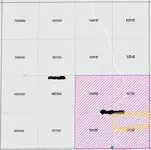
The MLRS just highlights 160 acres for a 20 acre claim. I pulled the location notice, and I believe the actual claim is in the area highlighted yellow.
Am I correct?
 

Attachments

  • claim location post.webp
    claim location post.webp
    10.7 KB · Views: 126
  • Map post.webp
    Map post.webp
    35.7 KB · Views: 73
Upvote 0

I have a tendency to think that I understand something correctly, just to find out I was way off. So, before I go prospect this place, I/m asking for a "dummy check" to make sure I'm understanding the location of this claim correctly.
The MLRS just highlights 160 acres for a 20 acre claim. I pulled the location notice, and I believe the actual claim is in the area highlighted yellow.
Am I correct?
Looks ok to me. Assuming that is a whole section shown. N1/2 of the SE1/4 of the SE1/4 of the section. That would theoretically be 20 acres. You did good.
 
Looks ok to me. Assuming that is a whole section shown. N1/2 of the SE1/4 of the SE1/4 of the section. That would theoretically be 20 acres. You did good.
Thanks! Working that close to a claim, want to be certain.
 
Thanks! Working that close to a claim, want to be certain.
Just remember that sections are not necessarily perfect 1 mile x 1 mile squares. They don’t all contain 640 acres.

Sections can be highly irregular, especially if they are in the north and west sides of the township. Original quarter corners can be hundreds of feet off in distance or line.

Personally I’d make a trip to the County Surveyors Office and see if that section was ever surveyed.

In some remote areas, the sections were never laid out. They call that “unsurveyed”. All of the topo maps and maps that depict the PLSS system will depict protracted sections which really are not sections at all. I believe mining claims in those areas should be metes and bounds descriptions rather than aliquot parts of a section (N1/2 of SE1/4, ect.) Not everyone knows that.

So beware or do additional research or find the claim notice.
 
Did you check with Land Matters, if there are any active claims there you can check on any status of the claims
They? did, but it only depicts a theoretical aliquot part that doesn’t represent a 20 acre claim or maybe even an actual surveyed section. Lots of disputes surrounding claims from non-surveyor types and people can be aggressive about claims.
 
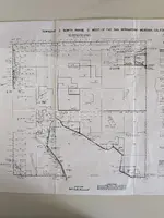
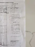
Joan, Chief, Lands Section Branch of Lands and Minerals Operations, sent me this Document with detailed info about my Claim I just need to learn the NE 1/4 S 1/2 SW 1/4 not in that order lol but lots going on back in the day in that area :icon_scratch:
 

Attachments

  • PXL_20260503_153639200.webp
    PXL_20260503_153639200.webp
    1.5 MB · Views: 71
  • PXL_20260503_152911880.webp
    PXL_20260503_152911880.webp
    1.4 MB · Views: 68
There is a handy legend map that explains all the cryptic abbreviations and line types. I’ll upload it tomorrow if you don’t find it sooner.
 
Sure, that would be cool to view TY.
 
So beware or do additional research or find the claim notice.
They? did, but it only depicts a theoretical aliquot part that doesn’t represent a 20 acre claim or maybe even an actual surveyed section. Lots of disputes surrounding claims from non-surveyor types and people can be aggressive about claims.
Thanks for the additional info. This area has been surveyed, multiple times. There are 4 different ages of USFS markers on the corners, so I'm certain of where I'm at on the ground at least. I haven't found the claim notice on the ground yet. Probably because I had assumed the claim was in the S 1/2, not the N 1/2 until I found out that I can look up the claim notice on the county's website.
It's really hard when they don't actually show what 20 acres are the actual claim on the MLRS and landmatters maps. Even more confusing when the claim owner has postings on the S 1/2 when his notice says the claim is on the N 1/2. :icon_scratch:
Fortunately, in this case, I'm working in a different corner, so N 1/2 or S 1/2 shouldn't matter.
Joan, Chief, Lands Section Branch of Lands and Minerals Operations, sent me this Document with detailed info about my Claim I just need to learn the NE 1/4 S 1/2 SW 1/4 not in that order lol but lots going on back in the day in that area :icon_scratch:
Understanding the meridian township is like trying to learn a new language! For the first 5 years of prospecting, I would get so confused trying to understand it all. I avoided areas with claim markings to be safe.
 
Thanks for the additional info. This area has been surveyed, multiple times. There are 4 different ages of USFS markers on the corners, so I'm certain of where I'm at on the ground at least. I haven't found the claim notice on the ground yet. Probably because I had assumed the claim was in the S 1/2, not the N 1/2 until I found out that I can look up the claim notice on the county's website.
It's really hard when they don't actually show what 20 acres are the actual claim on the MLRS and landmatters maps. Even more confusing when the claim owner has postings on the S 1/2 when his notice says the claim is on the N 1/2. :icon_scratch:
Fortunately, in this case, I'm working in a different corner, so N 1/2 or S 1/2 shouldn't matter.

Understanding the meridian township is like trying to learn a new language! For the first 5 years of prospecting, I would get so confused trying to understand it all. I avoided areas with claim markings to be safe.
Work the description backwards. I’ll try and remember the legend tomorrow.
 

Users who are viewing this thread

Back
Top Bottom