want a sea chart of the area of 31 degrees to 29 degrees and 12 / 16 miles out

ivan salis

Gold Member
Feb 5, 2007
16,794
3,809
callahan,fl
🏆 Honorable Mentions:
1
Detector(s) used
delta 4000 / ace 250 - used BH and many others too
I would like very much to get a sea chart of the area off ponte vedra area -- from 31 degrees to 29 degrees and from 12 to 16 miles out --basically 2 degrees tall by 4 miles wide .. to look for odd bottom items and shallow zones --I am looking for the missing patache of the 1641 fleet ...reportly it was found with survivors on it 5 "leagues" offshore by another patache sent from cuba later ..using the 2.6 mile to league its 13 miles and if 3 is used its 15 miles giving a bit for error say 1 mile closer and farther that's 12 to 16 miles ..it was reported at 30 degrees --again give some margin for error 29 to 31 degrees should cover it ---the lovely part is the distance offshore means that both the state of Florida and the US government have no permitting say so or involvement ...the date of 1641 is also before the 1750 cut off date that the Spanish govt agreed to to win the la gagla / juno case --so Spain should not be a factor either hopefully

I plan to be at the cookout this Saturday the 28th ...if anyone wants to chat with me
 

Last edited:

old man

Bronze Member
Aug 12, 2003
1,773
1,709
East Coast
I would like very much to get a sea chart of the area off ponte verda area -- from 31 degrees to 29 degrees and from 12 to 16 miles out --basically 2 degrees tall by 4 miles wide .. to look for odd bottom items and shallow zones --I am looking for the missing patache of the 1641 fleet ...reportly it was found with survivors on it 5 "leagues" offshore by another patache sent from cuba later ..using the 2.6 mile to league its 13 miles and if 3 is used its 15 miles giving a bit for error say 1 mile closer and farther that's 12 to 16 miles ..it was reported at 30 degrees --again give some margin for error 29 to 31 degrees should cover it ---the lovely part is the distance offshore means that both the state of Florida and the US government have no permitting say so or involvement ...the date of 1641 is also before the 1750 cut off date that the Spanish govt agreed to to win the la gagla / juno case --so Spain should not be a factor either hopefully

I plan to be at the cookout this Saturday the 28th ...if anyone wants to chat with me

Ivan,
Contact John Redman. I gave him a Nautical map of fisherman's snags going from S.C. to around the area that you ask about. I'm sure John would bring it to the cookout to show You. As long as he doesn't show it to others. I have no problem with him doing that.
 

OP
OP
ivan salis

ivan salis

Gold Member
Feb 5, 2007
16,794
3,809
callahan,fl
🏆 Honorable Mentions:
1
Detector(s) used
delta 4000 / ace 250 - used BH and many others too
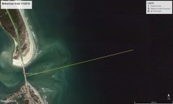
funny thing -- right about where the 1728 dutch map shows that there was a shipwreck area of of 1 or maybe both of the 2 missing vessels from Echevez fleet San Miguel nao (tobacco ship)-- the El Ciervo ( French prize vessel) 1715 fleet vessels * off Matanzas inlet --there is now a about 3 mile "(closed to navigation) " area --1 1/2 mile above / below the inlet 3 miles out to sea in a arc from the inlet
 

Salvor6

Silver Member
Feb 5, 2005
3,755
2,169
Port Richey, Florida
Detector(s) used
Aquapulse, J.W. Fisher Proton 3, Pulse Star II, Detector Pro Headhunter, AK-47
Primary Interest:
Shipwrecks
Bigger is not better. My little Yamaha wave runner jet ski can go in one inch of water!
 

CaptEsteban

Bronze Member
Jul 26, 2011
1,272
1,200
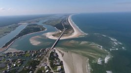
Those pix on that site look scary !! Wonder if they were taken at low tide ?
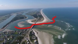
I don't think I would try it in most any rig. Some old the old 60's & 70's Tri-Hulls may make it. I have been on some of those that ran pretty shallow. A jon boat might navigate it , too , but not many of us want to take a jon boat out there. Maybe leave the river running along the lower side, near land. Once under the bridge, run the upper side near the coast. The picture below shows what I am describing.
 

Attachments

  • Matanzas Inlet.jpg
    Matanzas Inlet.jpg
    86.5 KB · Views: 162

FISHEYE

Bronze Member
Feb 27, 2004
2,333
400
lake mary florida
Detector(s) used
Chasing Dory ROV,Swellpro Splash 2 pro waterproof drone,Swellpro Spry+ wa,Wesmar SHD700SS Side Scan Sonar,U/W Mac 1 Turbo Aquasound by American Electronics,Fisher 1280x,Aquasound UW md,Aqua pulse AQ1B
Primary Interest:
All Treasure Hunting

Elite1

Tenderfoot
May 10, 2018
7
3
Primary Interest:
All Treasure Hunting
A wood wreck with a ballast pile or a modern steel wreck?
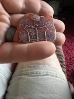
Hi sorry it took me a few years to get back here. Brain surgery screws up the memory. I think I found a shipwreck and I also believe I have found a sword. Not sure which kind if shipwreck.
 

Top Member Reactions

Users who are viewing this thread

Top