What Am I Looking At?

Random4219

Newbie
Jul 25, 2009
4
0

Attachments

  • Mounds.kml
    1.4 KB · Views: 1,024
  • Interesting Square.kml
    1.4 KB · Views: 485

allen_idaho

Hero Member
Dec 4, 2007
808
114
Culdesac, Idaho
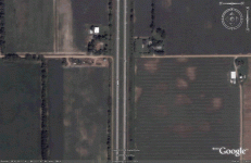
The mounds look like rotting hay to me. But it could also just be dirt. You never know.

The square looks like a maintained camping/recreation area. I think that is a restroom in the center.
 

jog

Bronze Member
Nov 28, 2008
1,364
682
Tillamook Oregon
Detector(s) used
Whites MXT / GMT
Primary Interest:
All Treasure Hunting
The mounds might be where someone has dug test holes.
 

Tank69

Silver Member
May 5, 2009
4,076
62
Yuma Az
Detector(s) used
Tesoro Eldorado , Fisher Gold Bug 2 , Whites MXT , Keen Dry Washer
Primary Interest:
All Treasure Hunting
#1 to me looks like large holes or dirt mounds .

#2 looks like a camping/Rec area

my 2 cents I'd cross the water there an go hunt 34°50'20.72"N 87°56'37.27"W not a bad looking beach an boat ramp
 

gmstreet

Full Member
Jul 29, 2007
121
3
Elkins, West Virginia
Detector(s) used
Whites DFX
Primary Interest:
All Treasure Hunting
Looks like areas where cows ate round haybales. The farmer would set the next one out in a different area afterwards, because the cows would make a mess while eating the hay. That's why there are so many. The circles are larger than the actual bale would have been because they would scatter the hay, track and crap in a circle around it.

Greg
 

jgowans

Full Member
Sep 19, 2008
209
7
Ellicott City, MD
They could be sand blows from the earthquake in 1811/12 New Madrid. I just saw a show on them this week.
They look like this.
http://www.scchealth.org/docs/doche/director/0508_director.html
sand_blows_0508.gif
 

S

stefen

Guest
Another possibility that they may be due to rotory irrigation heads operating with low pressure / low volumn capacity.
 

mrjosh

Full Member
Aug 1, 2008
137
0
Paducah, Kentucky & Hendersonville, Tn
Detector(s) used
Prizm III.
bullseye pinpointer
Ace 400
Primary Interest:
Metal Detecting
The mounds seem to big for hay mounds to me, it looks like there is some height to them. I would think i they were old that they would be grass covered.
 

Salvor6

Silver Member
Feb 5, 2005
3,755
2,169
Port Richey, Florida
Detector(s) used
Aquapulse, J.W. Fisher Proton 3, Pulse Star II, Detector Pro Headhunter, AK-47
Primary Interest:
Shipwrecks
That square is Colbert Island State Park.
 

Feb 23, 2009
364
8
Moscow-ish, Pa
Detector(s) used
Minelab X-Terra 705 w/7.5&3kHz coils
Spooky said:
Well, they weren't there in 1999. (using the later image from google earth)
But they WERE there in 2006.


Hmmmmm.......

That rules out MY guess!

Being and former Redleg.....I was gonna suggest an old artillery range impact zone!
 

Monty

Gold Member
Jan 26, 2005
10,746
166
Sand Springs, OK
Detector(s) used
ACE 250, Garrett
Primary Interest:
All Treasure Hunting
Just recently I went with Burdie, Stoney 56 and Mental Granny to a site where there were several similar looking circles that was thought to be old tepee sites where an Indian summer camp existed. Alas, we found out it was where round hay bales had been set out for cattle. So, I see they have already been ID'd as such. Good Job! Monty
 

Curtis

Hero Member
Sep 3, 2008
899
1,009
Cincinnati
Primary Interest:
All Treasure Hunting
Hope your right about the mounds! I liked the sand hole idea too! Might be hay bales...might be site of the area serial killers body dump too! Could also be where there were trees that got as grandpa use to say "root waded up”! This blown down trees theory is that the root end would pull earth up with the roots, then when the tree decayed there would be a mound left. The rest of the tree would not show after awhile.
 

Monty

Gold Member
Jan 26, 2005
10,746
166
Sand Springs, OK
Detector(s) used
ACE 250, Garrett
Primary Interest:
All Treasure Hunting
There is a town not far from me named Mounds. The reason is because it is right in the middle of an area with hundreds of Indian mounds built many years ago. Several of the mounds were excavated years ago by the well meaning Archies and a lot Indian artifacts were dug up and now most of it resides in museums. I suspect a lot of it resides in various Archie personal collections, but don't know that for a fact. Now it is forbidden to dig up a mound as they are considered sacred by modern Indians and besides it is just poor taste. I'm not positive but I think many of them are burial mounds and the artifacts are there to serve the deceased in the after life. Makes sense to me. Monty
 

ZINCLID

Full Member
Apr 2, 2010
169
4
ALABAMA
Detector(s) used
Mostly Tesoro units-I've owned five of them--but I've used Whites,Fishers,Garretts,Nautilus, Minelab, and Detex.
Primary Interest:
All Treasure Hunting
I'm not sure what did that??? Could be that some type of equipment did it? Who knows? Don't look like usual crop circle patterns on most of it.
 

digging wv

Sr. Member
Sep 16, 2007
302
98
Cabin Creek
Detector(s) used
Prizm V
Primary Interest:
All Treasure Hunting
I've got lot's and lot's of hours flying around the country in USMC CH-46 and CH-53 helos. (back in the day) All our altitudes never exceded 10,000 feet so we had a lot of low level stuff.We made frequent trips from east coast to west and back again. I've seen patterns such as those pictured across the country. I'm sure you have dug a hole with one type of soil and a few hundreds yards you get something else. Well this is just a birds eye :hello: view of that. It makes for an interesting picture but it's a very common thing.
 

dirty_digger

Jr. Member
Jan 8, 2010
94
8
Jacksonville, AR
Detector(s) used
Whites Eagle Spectrum
The "mounds" picture could also be a plant disease. There is some kind of fungus or bacteria that will grow in a cirlce like that. Some will get HUGE. You can find them all across the Central and Southern U.S. I found many of them on Google Earth. Sometimes you can go out to the site and cant find the circle. They can fade during the seasons changing or blend in really well when your standing right on top of them.

Just my two cents.....
 

AlabamaRelic

Hero Member
Jul 2, 2009
523
528
NW Alabama
Detector(s) used
Ace 250
I finally took the time to drive out and look at this. I couldn't see the exact spot where the mounds are due to the lay of the land. However, on the west side of the field were where round bales of hay had been fed to the cows this winter. The cows had spread the hay out in 30'+ circles. So I would say it's hay.
 

Top Member Reactions

Users who are viewing this thread

Latest Discussions

Top