
You are using an out of date browser. It may not display this or other websites correctly.
You should upgrade or use an alternative browser.
You should upgrade or use an alternative browser.
Where is all that Gold and Silver?
- Thread starter Chagy
- Start date
 ?
?If you recall that I once said that there had to be a SPRING of fresh water located near ANY Indian Village.
The are still a few fresh water running springs located throughout Brevard County and not to far from the beach area.
Now all you have to do is find them and when you do there will be a Indian Village not far away-GUARANTEED
Peg Leg
The are still a few fresh water running springs located throughout Brevard County and not to far from the beach area.
Now all you have to do is find them and when you do there will be a Indian Village not far away-GUARANTEED
Peg Leg
Was given a NEW MAP SITE.
www.maps.live.com
It is the best system I have ever seen. You can get close enough to see the branches on the trees.
Here is something very interesting.
I checked out the BIG ISLAND in the BANANA RIVER.
I located what I believe is a Fresh Water spring.
You will also notice that there is NOT a single canal cut on this island-STRANGE until you look at the whole picture.
I BELIEVE THAT THIS ISLAND WAS USED TO STASH TREASURE BY THE AIS INDIANS.
So if anyone wants to check it out HAVE AT IT and good luck.
Peg Leg
www.maps.live.com
It is the best system I have ever seen. You can get close enough to see the branches on the trees.
Here is something very interesting.
I checked out the BIG ISLAND in the BANANA RIVER.
I located what I believe is a Fresh Water spring.
You will also notice that there is NOT a single canal cut on this island-STRANGE until you look at the whole picture.
I BELIEVE THAT THIS ISLAND WAS USED TO STASH TREASURE BY THE AIS INDIANS.
So if anyone wants to check it out HAVE AT IT and good luck.
Peg Leg

Bigcypresshunter
Sapphire Member
- Joined
- Dec 15, 2004
- Messages
- 27,124
- Reaction score
- 3,351
- Golden Thread
- 0
- Location
- South Florida
- Detector(s) used
- 70's Whites TM Amphibian, HH Pulse, Ace 250
- Primary Interest:
- Beach & Shallow Water Hunting
I never stated that treasure ships or shipping lanes were attacked. Calusa had no pirate ships that I know of. I read of a large organized attack on one of Ponce De Leon's ships by Calusa Indian archers in dugout canoes. Francisco Hernández de Córdova also may have been attacked. I am stating from memory only. If I get around to it I will look for a link or the library book. No promises.Jeff K said:I've never read anywhere that Carlos attacked Spanish shipping.

I agree. This is well known. Carlos's village was at the mouth of the Caloosahatchee River were travel could be made to Lake Okeechobee by canoe. (through Ortona canals) Treasure must have been transported along this route all the way from the East Coast somehow.Jeff K said:In any event, Carlos' village was on Mound Key in Estero Bay, and it's an archaeological site now. No treasure hunting allowed.
http://www.floridastateparks.org/moundkey

There were many other villages on the SW coast. Marco Island comes to mind, where many artifacts were found.
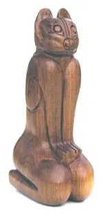
 Cat found at Marco Island before developement. http://www.sanybel.com/calusa_indian.htm
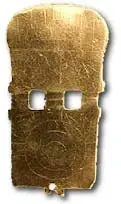
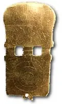
 Gold medallion found near Chokoloskee Island.
Attachments

ivan salis
Platinum Member
- Joined
- Feb 5, 2007
- Messages
- 16,836
- Reaction score
- 3,817
- Golden Thread
- 0
- Location
- callahan,fl
- Detector(s) used
- delta 4000 / ace 250 - used BH and many others too
the dutch "galleon raiders" reportedly watered near the cocoa beach area because of the high water table that allowed there to be a few fresh water springsnear the beaches --- if you know where these fresh water "springs" near the beaches are they might be worth looking at for artifacts and such --- both Ita and Hyen put the hurt on the spanish shipping in 1628 ish time frame
Bigcypresshunter
Sapphire Member
- Joined
- Dec 15, 2004
- Messages
- 27,124
- Reaction score
- 3,351
- Golden Thread
- 0
- Location
- South Florida
- Detector(s) used
- 70's Whites TM Amphibian, HH Pulse, Ace 250
- Primary Interest:
- Beach & Shallow Water Hunting
So little is known about the shipwrecks of the 1500's. Where are they?RGecy said:Peg,
I have several pages of documents that talk about the fort of Carlos. The letters date to 1573 and he had held captive 20 Spanish sailors for at least 20 years. This means the wreck would have dated to 1553.
I believe that the wrecks of this period were mainly on the Gulf coast.
By the way I have discovered a Fresh water spring in the BANANA RIVER.
Of course without going there I cannot prove one way or the other and since I am in the middle of moving to St. Augustine in Dec. we will never know unless some is willing to check this site out but if someone is intersted I will tell the EXACT location.
One other thing I find strange is on some of the canals there appears to be mounds of sand but there are NOT sand mounds but TREES.
For the location you can PM.
Peg leg
By the way I have discovered a Fresh water spring in the BANANA RIVER.
Of course without going there I cannot prove one way or the other and since I am in the middle of moving to St. Augustine in Dec. we will never know unless some is willing to check this site out but if someone is intersted I will tell the EXACT location.
One other thing I find strange is on some of the canals there appears to be mounds of sand but there are NOT sand mounds but TREES.
For the location you can PM.
Peg leg
Bigcypresshunter
Sapphire Member
- Joined
- Dec 15, 2004
- Messages
- 27,124
- Reaction score
- 3,351
- Golden Thread
- 0
- Location
- South Florida
- Detector(s) used
- 70's Whites TM Amphibian, HH Pulse, Ace 250
- Primary Interest:
- Beach & Shallow Water Hunting
I wouldnt bother looking in the mounds, (its illegal anyway) unless you are looking for discarded bones and shells. Maybe treasure is underwater somewhere. 
What are all those lines that look like sunrays in the aerial photo that JeffK posted in reply #61? Are those ancient canals?
What are all those lines that look like sunrays in the aerial photo that JeffK posted in reply #61? Are those ancient canals?
Here is something I find interesting.
Using www.maps.live.com
You can see a canal (Cucumber Island) from the upper right hand side all the way to the Atlantic Ocean of course you can also see where this canal has filled in just west of the dirt road for a distance of about 200 feet but it is plain to see anyway.
I have also discovered that at certain locations that what apperas to be SAND MOUNDS from dredging are actually TREES. These trees appear to be a certain type of tree because they do not match the rest of the foliage.
MORE mystery but WHAT IF:
These trees were planted to provide SHIP building material.
OR material to construct CANOES?
Check it out.
Peg leg
Using www.maps.live.com
You can see a canal (Cucumber Island) from the upper right hand side all the way to the Atlantic Ocean of course you can also see where this canal has filled in just west of the dirt road for a distance of about 200 feet but it is plain to see anyway.
I have also discovered that at certain locations that what apperas to be SAND MOUNDS from dredging are actually TREES. These trees appear to be a certain type of tree because they do not match the rest of the foliage.
MORE mystery but WHAT IF:
These trees were planted to provide SHIP building material.
OR material to construct CANOES?
Check it out.
Peg leg
After looking at the cool pictures I reslized how the Indians were abot to dig the canals.
They were able to use wood just like the Chinese use today and have used for several thousand years.
Take a piece of timber and attach rope or vines to the PLANK or BOARD. Have people DRAG this board-similart to the DRAGLINE.
THINK WHAT YOU CAN MOVE and how much you could move using the process.
I believe this was the way the Indiands were able to dig these canals and not by using shells.
Even the ROMANS used this process and you can see how they were able to build some serious canals.
Peg Leg
They were able to use wood just like the Chinese use today and have used for several thousand years.
Take a piece of timber and attach rope or vines to the PLANK or BOARD. Have people DRAG this board-similart to the DRAGLINE.
THINK WHAT YOU CAN MOVE and how much you could move using the process.
I believe this was the way the Indiands were able to dig these canals and not by using shells.
Even the ROMANS used this process and you can see how they were able to build some serious canals.
Peg Leg

Chagy
Bronze Member
- #73
Thread Owner
Peg Leg said:Here is something I find interesting.
Using www.maps.live.com
You can see a canal (Cucumber Island) from the upper right hand side all the way to the Atlantic Ocean of course you can also see where this canal has filled in just west of the dirt road for a distance of about 200 feet but it is plain to see anyway.
I have also discovered that at certain locations that what apperas to be SAND MOUNDS from dredging are actually TREES. These trees appear to be a certain type of tree because they do not match the rest of the foliage.
MORE mystery but WHAT IF:
These trees were planted to provide SHIP building material.
OR material to construct CANOES?
Check it out.
Peg leg
Peg,
Some Indians made there canoes using only one tree....only one piece canoe
Chagy
Bronze Member
- #74
Thread Owner
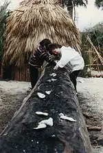
It took 28 days or "1 moon" to make
a canoe. After burning the middle they
would scrape the ash away with shells
http://www.greatdreams.com/canoe2.htm
a canoe. After burning the middle they
would scrape the ash away with shells
http://www.greatdreams.com/canoe2.htm
Attachments
Bigcypresshunter
Sapphire Member
- Joined
- Dec 15, 2004
- Messages
- 27,124
- Reaction score
- 3,351
- Golden Thread
- 0
- Location
- South Florida
- Detector(s) used
- 70's Whites TM Amphibian, HH Pulse, Ace 250
- Primary Interest:
- Beach & Shallow Water Hunting
Correct, they made dugout canoes from large thousand year old Bald Cypress trees...one tree. No need to plant Cypress as they were plentiful. Even Mohaghany trees were once plentiful in South Florida (the only real Mohaghany) and can still be found in the Keys. Brazilwood was logged in South America. The Spanish would not plant trees either. They abused and used any available resource.Chagy said:Peg Leg said:Here is something I find interesting.
Using www.maps.live.com
You can see a canal (Cucumber Island) from the upper right hand side all the way to the Atlantic Ocean of course you can also see where this canal has filled in just west of the dirt road for a distance of about 200 feet but it is plain to see anyway.
I have also discovered that at certain locations that what apperas to be SAND MOUNDS from dredging are actually TREES. These trees appear to be a certain type of tree because they do not match the rest of the foliage.
MORE mystery but WHAT IF:
These trees were planted to provide SHIP building material.
OR material to construct CANOES?
Check it out.
Peg leg
Peg,
Some Indians made there canoes using only one tree....only one piece canoe
I understand that the natives in Florida were able to construct canoes from the Bald Cypress.
If you will recall I posted about seeing a 60 foot long canoe recovered from the St. Johns River where the OSTEAN Bride now stands.
I understand that there is a large Mound but this mound was not discovered where the clearing of the river bed was being conducted.
I was lead to believe that there was a town located at this site called MELLON TOWN which I now believe it was a FORT MELLON also located at this site.
I am just looking for a few answers to WHO may have done this canal building and why.
So far the Corp of Engineers and the State of Florida do not have any answers or are not willing to explain these canals simply because they HAVE NO IDEA and do not want to persue something that may be controversial and believe me this may grow into just that.
I will listen to any thoughts concerning these CANALS no matter how far out they may be.
Thanks
Peg Leg
If you will recall I posted about seeing a 60 foot long canoe recovered from the St. Johns River where the OSTEAN Bride now stands.
I understand that there is a large Mound but this mound was not discovered where the clearing of the river bed was being conducted.
I was lead to believe that there was a town located at this site called MELLON TOWN which I now believe it was a FORT MELLON also located at this site.
I am just looking for a few answers to WHO may have done this canal building and why.
So far the Corp of Engineers and the State of Florida do not have any answers or are not willing to explain these canals simply because they HAVE NO IDEA and do not want to persue something that may be controversial and believe me this may grow into just that.
I will listen to any thoughts concerning these CANALS no matter how far out they may be.
Thanks
Peg Leg
Bigcypresshunter
Sapphire Member
- Joined
- Dec 15, 2004
- Messages
- 27,124
- Reaction score
- 3,351
- Golden Thread
- 0
- Location
- South Florida
- Detector(s) used
- 70's Whites TM Amphibian, HH Pulse, Ace 250
- Primary Interest:
- Beach & Shallow Water Hunting
Peg, your link is not coming up, only the home page. Can you post the pic of aerial photo?Peg Leg said:Here is something I find interesting.
Using www.maps.live.com
You can see a canal (Cucumber Island) from the upper right hand side all the way to the Atlantic Ocean of course you can also see where this canal has filled in just west of the dirt road for a distance of about 200 feet but it is plain to see anyway...
...Check it out.
Peg leg
I wish you would find something closer to where I live.

Are you talking about the canals RGecy posted or Banana River or Cucumber Island or Mound Key? You lost me somewhere.Peg Leg said:I am just looking for a few answers to WHO may have done this canal building and why.
So far the Corp of Engineers and the State of Florida do not have any answers or are not willing to explain these canals simply because they HAVE NO IDEA and do not want to persue something that may be controversial and believe me this may grow into just that.
I will listen to any thoughts concerning these CANALS no matter how far out they may be.
Thanks
Peg Leg
Actually I was talking about the photo that Robert posted.
This area is called Cucumber Island.
I then covered the BIG ISLAND in the Banana River.
Go to
www.maps.live.com
I have no idea where Mound Key is located.
Better than GOOGLE EARTH-MUCH MUCH BETTER.
Peg leg
This area is called Cucumber Island.
I then covered the BIG ISLAND in the Banana River.
Go to
www.maps.live.com
I have no idea where Mound Key is located.
Better than GOOGLE EARTH-MUCH MUCH BETTER.
Peg leg
Bigcypresshunter
Sapphire Member
- Joined
- Dec 15, 2004
- Messages
- 27,124
- Reaction score
- 3,351
- Golden Thread
- 0
- Location
- South Florida
- Detector(s) used
- 70's Whites TM Amphibian, HH Pulse, Ace 250
- Primary Interest:
- Beach & Shallow Water Hunting
You contacted the State and the Army Corps of Engineers? They didnt know? It looks like canals dug for waterfront homes and developement... just a guess. (Roberts pic)Peg Leg said:Actually I was talking about the photo that Robert posted.
This area is called Cucumber Island.
I then covered the BIG ISLAND in the Banana River.
Go to
www.maps.live.com
I have no idea where Mound Key is located.
Better than GOOGLE EARTH-MUCH MUCH BETTER.
Peg leg
I used your maps.live to search the Everglades and I actually can see an airboat at one of our old camps. 8)
bigcypresshunter,
That is correct.
No one knows a thing about this island and you will notice that the sand road to the east near the ocean goes nowhere else.
Did you also notice the canal dug to the ocean?
The reason that I mentioned the BIG ISLAND is the fact there is not a single canal through it.
Alos pay close attention to the round body of water on the island. Look at the middle of this pond and you will see a dark circle.
This is either a fresh water spring or a sink hole but I believe it is a SPRING.
A perfect place for AIS teasure to be located.
Peg Leg
That is correct.
No one knows a thing about this island and you will notice that the sand road to the east near the ocean goes nowhere else.
Did you also notice the canal dug to the ocean?
The reason that I mentioned the BIG ISLAND is the fact there is not a single canal through it.
Alos pay close attention to the round body of water on the island. Look at the middle of this pond and you will see a dark circle.
This is either a fresh water spring or a sink hole but I believe it is a SPRING.
A perfect place for AIS teasure to be located.
Peg Leg


Featured Treasure Finds
Featured Treasure Finds
Similar threads
Users who are viewing this thread
Total: 1 (members: 0, guests: 1)















