What's new

A Geometric Swamp and a Geometry of the Island

gjb

Sr. Member
Joined
Apr 21, 2016
Messages
451
Reaction score
428
Golden Thread
0
Location
UK
Detector(s) used
Garrett Ace 300i
Garrett EuroAce
Primary Interest:
All Treasure Hunting
Although I’ve explained this in detail a number of times on the forum, I appreciate that there may be newcomers here and the following might complement and perhaps reinforce the focus on the swamp seen on The Curse of Oak Island.

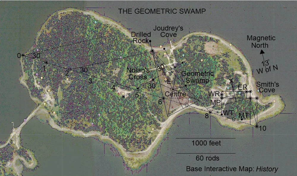
The suggestion is predicated on the suspicion that there may have been an overall geometry applied to the island heavily incorporating the ancient roadway, and, specifically, that a survey of the island would have been undertaken which resulted in survey markers being positioned and then left in situ, some of which have been, and are being, found. However, it could have been that some of these ground markers were also pointers, that is, clues as to the nature of the layout and thus how to reproduce it. The Geometric Swamp emerges from investigating this possibility.
OIGeoSwamp.webp


The geometry above has been superimposed on an interactive map from History's 'reality' show The Curse of Oak Island in order to illustrate its fit. I assume they won’t object! MP is the Money Pit, WR and ER are the rocks and WT and MT are the triangles, all geometrically positioned. E is the Eye of the Swamp and X marks the spot!

It's impossible to determine whether or not the many wooden stakes removed from the swamp might align with the suggested figure, since no information is ever forthcoming from the island and some of the information provided is clearly outright wrong and therefore misleading, doubtless intentionally.

The Roadway with its continuation is drawn above as 10 sections of 25 rods thus being 1375 yards long (1257m), just short of three-quarters of a mile. It bears at azimuth 107 degrees (17 degrees south of due east). As observed in a recent thread concerning La Formule, the centre of the Geometric Swamp is some 374 feet from both the Head Stone and Cone D of Nolan’s Cross.

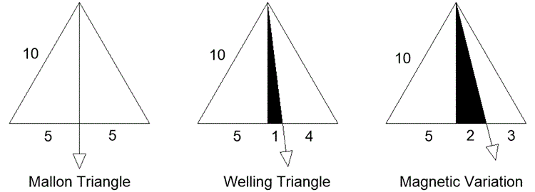
Should tunnels have been cut on the island then it would follow that magnetic compasses were employed in order to navigate underground. However, the bearing of the magnetic compass varies from place to place and over time, and only ocasionally points true to the poles. The angle of difference is frequently referred to as magnetic declination, though I prefer the term magnetic variation.

It would follow that were there tunnels on Oak Island then they would likely betray the angle of magnetic variation operating at the time. However, it's quite possible that a clue was left on the island to indicate what this was. The suggestion is that this was the function of the Welling Triangle, the angle indicated being the arc that is twice the tangent of tilt, or 13 degrees west of north.
OIMagVar.gif


Should this be correct, then it was perhaps desirable that this angle needed to be known by someone other than the originator. For what purpose? The location of the Money Pit was made obvious to everybody and they're still digging there (:dontknow:). So, why would it be necessary to provide any other information? Since such information seems to have been intentionally left, I suggest that the focus of the island's geometry is definitely not the Money Pit, and there's a lot pointing to this.

Details are scattered across my previous posts, while a full explanation in the form of an armchair treasure hunt can be found in my book The Oak Island Concealment: Seeing Beyond the Money Pit.
 
I understand the use of sacred geometry to select a treasure location but i don't see the benefit over finding two natural landmarks far enough a part not to look suspicious yet close enough to accurately pace off a distance between the two markers to select a treasure location.

What would the treasure recovery look like when using sacred geometry?
Do find the stone triangle first? Do you need to the find all the drilled rocks, etc.
Or is there a quicker way to re-locate the treasure?
 
I asked Google AI about the accuracy of surveying a treasure location in the 1600s and it indicated triangulating boulders over 100ft apart would have significant inaccuracies build up causing the location to be off by dozens of feet.

This inaccuracy could explain why boulders in Nolans cross are not aligned perfectly when Nolan used modern methods.

It also suggests the distances from the stone triangle, drilled stones Nolan are large enough (i.e., hundreds of feet) to introduce enough error that the treasure would not be found upon their return...either the original placement or the survey performed by returning depositors or both are significantly inaccurate.
 
Google AI...
Based on the constraints of 1700s surveying methods and the use of boulders as markers 100s of feet apart, the probability of finding a specific treasure location is extremely low, likely under 5–10%, even with a calculated target area.
 
Google AI...
Based on the constraints of 1700s surveying methods and the use of boulders as markers 100s of feet apart, the probability of finding a specific treasure location is extremely low, likely under 5–10%, even with a calculated target area.
Your AI can only tell you what others have told it, and it doesn't actually know whether they got it right. Also, your AI has never conducted surveys, particularly before the widespread use of electronic equipment. Plane table surveying can be accurate. I have personally undertaken such surveys and have also used basic alt-azimuth devices, alidades, levelling over hundreds of yards, without electronic aids, to within inches on closing. I've also used a surveyor's chain back in the day (and didn't like it). The problem isn't equipment, it's knowledge, technique and concentration and, much of the time, sheer hard work - and definitely checking and confirming what you've done.

Alidade1722.webp


It's said that the Welling Triangle was due south of the westerly drilled rock, and that the two points were about 112 yards apart. This is definitely not a problem! However, you're saying that this couldn't have been achieved at all accurately after 1700. This task is actually a very simple one! Furthermore, your AI is likely not taking account of the huge improvements in surveying equipment during the 18th century. The problem is not so much after 1700, its before, particularly if using an astrolabe over distances and sloping ground.

AstrolabeUse.webp


The Drilled Rocks were separated by 421.5 feet at 7 degrees, not visible from each other and at different levels. You may not be able to achieve that, but I could as could anyone with the training and practical experience even in the 18th century. I just wouldn't, or couldn't, attempt it on my own, even with electronic equipment - and of course there would be trees in the way. That might create a problem, but it's not insurmountable.

You're also assuming that someone would actually measure out all the distances on the ground, but they'd only have to survey and plot the ground markers and, thereafter, work everything out on paper (mathematically), finally taking the simplest direct route to the desired point. What's more, they'd find a way to check independently that they were at the right spot, and they'd keep at it until they got it right.

So, I'd seriously advise you not to rely entirely on AI, and to do your own research to supplement and check what it tells you.
 
Your AI can only tell you what others have told it, and it doesn't actually know whether they got it right. Also, your AI has never conducted surveys, particularly before the widespread use of electronic equipment. Plane table surveying can be accurate. I have personally undertaken such surveys and have also used basic alt-azimuth devices, alidades, levelling over hundreds of yards, without electronic aids, to within inches on closing. I've also used a surveyor's chain back in the day (and didn't like it). The problem isn't equipment, it's knowledge, technique and concentration and, much of the time, sheer hard work - and definitely checking and confirming what you've done.

View attachment 2253611

It's said that the Welling Triangle was due south of the westerly drilled rock, and that the two points were about 112 yards apart. This is definitely not a problem! However, you're saying that this couldn't have been achieved at all accurately after 1700. This task is actually a very simple one! Furthermore, your AI is likely not taking account of the huge improvements in surveying equipment during the 18th century. The problem is not so much after 1700, its before, particularly if using an astrolabe over distances and sloping ground.

View attachment 2253608

The Drilled Rocks were separated by 421.5 feet at 7 degrees, not visible from each other and at different levels. You may not be able to achieve that, but I could as could anyone with the training and practical experience even in the 18th century. I just wouldn't, or couldn't, attempt it on my own, even with electronic equipment - and of course there would be trees in the way. That might create a problem, but it's not insurmountable.

You're also assuming that someone would actually measure out all the distances on the ground, but they'd only have to survey and plot the ground markers and, thereafter, work everything out on paper (mathematically), finally taking the simplest direct route to the desired point. What's more, they'd find a way to check independently that they were at the right spot, and they'd keep at it until they got it right.

So, I'd seriously advise you not to rely entirely on AI, and to do your own research to supplement and check what it tells you.
I was simply pointing out that surveying over terrain, through wooded sections and placement of stones/boulders markers using 1700s methods is subject to increased measurements errors the further the distance is.

So for me the method and distance (i.e., 100s of feet) suggested is in adequate to achieve the accuracy needed to locate the treasure upon their return.

This is based on the following depositor scenario...
1. The depositors determine the location for the treasure vault.
2. They survey triangulation points based on sacred geometry
3. They place markers at the triangulation points
4. They bury the treasure.

Recovery scenario...
1. Upon return the depositors locate the triangulation points.
2.They triangulate/survey back to the treasure location.
3. They dig up the treasure.

The further the stone markers are from the treasure location the greater the chance the accumulated measurement errors will cause returng party to dig in the wrong location.

If the treasure is not deep, multiple holes wouldn't be a problem but if buried 100ft deep you only get one chance during the dry season on OI.

So im actually suggesting that someone with a vast treasure would choose a location, distance and triangulation points that guarantees they will recover the treasure upon their return.
 
I was simply pointing out that surveying over terrain, through wooded sections and placement of stones/boulders markers using 1700s methods is subject to increased measurements errors the further the distance is.

So for me the method and distance (i.e., 100s of feet) suggested is in adequate to achieve the accuracy needed to locate the treasure upon their return.

This is based on the following depositor scenario...
1. The depositors determine the location for the treasure vault.
2. They survey triangulation points based on sacred geometry
3. They place markers at the triangulation points
4. They bury the treasure.

Recovery scenario...
1. Upon return the depositors locate the triangulation points.
2.They triangulate/survey back to the treasure location.
3. They dig up the treasure.

The further the stone markers are from the treasure location the greater the chance the accumulated measurement errors will cause returng party to dig in the wrong location.

If the treasure is not deep, multiple holes wouldn't be a problem but if buried 100ft deep you only get one chance during the dry season on OI.

So im actually suggesting that someone with a vast treasure would choose a location, distance and triangulation points that guarantees they will recover the treasure upon their return.
Might they not simply place a marker fairly close to the target location, easily identifiable and found from other ground markers, and then offset from that station in order to improve accuracy?

Might they not also start with the geometry and chose a location upon it at which to make the deposit, then place ground markers at other key points on the geometry thereafter providing instructions on how to make use of them?
 
Might they not simply place a marker fairly close to the target location, easily identifiable and found from other ground markers, and then offset from that station in order to improve accuracy?

Might they not also start with the geometry and chose a location upon it at which to make the deposit, then place ground markers at other key points on the geometry thereafter providing instructions on how to make use of them?
Im sure there were ways an experienced surveyor could improve accuracy but the question becomes..."why place boulders hundreds of feet apart when under 100ft would be adequate and more reliable.

Yes. They could have drawn the sacred geometry on the island first to pick the treasure location.
Yes. If they kept the geometric drawing of the island and geometry, they would have instructions to locating the treasure: however, the implementation of the treasure vault to match the drawing of the island introduces another source of error.
It would give the recovery party an idea where to dig next after they fail to find the treasure on the first attempt.
 
I see nolans cross as the island identifier where the recovery party lands at jourdey cove to find the first boulder of nolans cross. They can quickly use 30/60 degree angles to find the other boulders to conclude...
Yes! We have the correct island.

If nolans cross is tied to treasure, then there is a second part/map to actually find the treasure. Maybe the "le formule"

One could use the Nolan cross boulders as the starting point and then use "le formule" to plot potential treasure locations.
 

Attachments

  • Screenshot_20260514_102719_Chrome.webp
    Screenshot_20260514_102719_Chrome.webp
    76.8 KB · Views: 50
  • Like
Reactions: gjb
Aren't you assuming that they're actually placing the markers hundreds of feet apart expecting somebody to measure this on the ground? Let's say a marker is placed on the beach at Smith's Cove and a marker is positioned at the Money Pit some 500 feet away. Then, a drilled stone marker is located 60 feet north of the Pit marker and another drilled stone marker at 70 feet west of the Beach marker, not massive distances. Thus, the distance between the rocks is some 430 feet, but this wasn't actually measured out and nobody is expected to do so.

That's because I could mark the four points to scale on a piece of paper and perform any amount of calculations and plot any amount of movements on the sheet of paper without going anywhere near any of the markers or measuring from or between them. Perhaps, having done this I find that I need to dig 40 feet east of the westerly stone marker. I can find this point with ease and I haven't been measuring great distances on the ground except initially to locate the Money Pit. I've simply identified the ground markers, plotted them, and then I've done all the work on a sheet of paper sitting at my desk.

 
I see nolans cross as the island identifier where the recovery party lands at jourdey cove to find the first boulder of nolans cross. They can quickly use 30/60 degree angles to find the other boulders to conclude...
Yes! We have the correct island.

If nolans cross is tied to treasure, then there is a second part/map to actually find the treasure. Maybe the "le formule"

One could use the Nolan cross boulders as the starting point and then use "le formule" to plot potential treasure locations.
Exactly! You could do likewise at the east of the island using the drilled rocks. In fact, you could combine the two and if you identify the same spot then you could be fairly confident that you're on the right track!
 
My feeling is that Nolan's Cross and La Formule are what I call confirmation clues. That is, if you know about Nolan's Cross then you can confirm that the first step towards the solution at the east of the island is correct. Then, if you have La Formule you can confirm that the second step to the solution is correct. Is there are a third step to the solution? I don't know!
 
Im been learning about sacred geometry and although i may be convinced nolans cross is man made im not convinced its is sacred geometry. My issue is that you can use the 6 boulders to draw 6 triangles but only 2 of the 6 (33%) are 30-60-90 triangles. It would be more believable if you remove cone D reducing reducing the triangles from 6 to 4 (50%) so this tells me cone D was not placed there for the geometry but for another reason.

The angle of the cross is commonly said to be 30 deg (i.e., sacred geometry) but i read where it is actuallu 35 deg. Just like cone D, this would indicate the 35 deg was chosen not for geometry but for another reason.

How do you determine when sacred geometry is used?
When used in a cathedral, sacred geometry would be repeatedly on display in every room dimension, every window, etc.. it is undoubtedly sacred geometry but for nolans cross there is just one cross with only two 30 deg angles which doesn't scream "sacred geometry". So what is the criteria for concluding nolans cross is sacred geometry?

I ask because...
If your conclusion about sacred geometry is wrong and cone D and the angle of 35 deg are there for anther reason then you'll never solve the mystery.
 

Attachments

  • Screenshot_20260515_062528_Chrome.webp
    Screenshot_20260515_062528_Chrome.webp
    16.5 KB · Views: 35
I will add,...
Sacred geometry communicates that the universe is governed by a divine, orderly blueprint, suggesting all life is interconnected through fundamental patterns

Nolans cross doesn't fit this ideal.
 
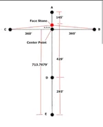
The total height of nolans cross is 145+429+293=867ft.

I asked Google AI how to create a cross 867ft high using sacred geometry.
1. The cross beam/ arms should be locater 1/4 of the way down the height: 217ft
2. Two methods can be used to calculate the length of the cross beam...
A) golden ratio: 1.618 x the height=536ft
Or
B) 2/3 the height=578ft

Notice when using this criteria that there are no 30-60-90 triangles. I asked Google about this...the golden ratio takes precedent over the 30-60-90 triangle making the 30 deg angle secondary.

Based on Google AI, I would conclude nolans cross has nothing to do with sacred geometry.
 
Im been learning about sacred geometry and although i may be convinced nolans cross is man made im not convinced its is sacred geometry. My issue is that you can use the 6 boulders to draw 6 triangles but only 2 of the 6 (33%) are 30-60-90 triangles. It would be more believable if you remove cone D reducing reducing the triangles from 6 to 4 (50%) so this tells me cone D was not placed there for the geometry but for another reason.

The angle of the cross is commonly said to be 30 deg (i.e., sacred geometry) but i read where it is actuallu 35 deg. Just like cone D, this would indicate the 35 deg was chosen not for geometry but for another reason.

How do you determine when sacred geometry is used?
When used in a cathedral, sacred geometry would be repeatedly on display in every room dimension, every window, etc.. it is undoubtedly sacred geometry but for nolans cross there is just one cross with only two 30 deg angles which doesn't scream "sacred geometry". So what is the criteria for concluding nolans cross is sacred geometry?

I ask because...
If your conclusion about sacred geometry is wrong and cone D and the angle of 35 deg are there for anther reason then you'll never solve the mystery.
I've never claimed that the suggested geometry is 'Sacred Geometry'! To me, it's just geometry, the stuff I was taught at school and the stuff I use when I'm surveying land! My suggestion is that the originator used geometry (Euclid, as he'd been taught) in drawing up a plan of the island and, to make things easier, employed angles of 30 and 60 degrees and expressed the angle of magnetic variation as a function of 30 degrees.

That way, the pieces fit much better. Ad triangulum and ad quadratum just happen to make outcomes (building and landscape designs) more aesthetic. Geometry is still used in building and land layouts to this day, and in surveying, and nobody, but nobody, is calling it Sacred Geometry!

I've seen the suggestion that the bearing of the Cross is 35 degrees, but this goes against what surveys have found. Petter Amundsen used sub-metre GPS to plot the positions of the cones and confirmed the bearing to be 30 degrees. Indeed, the History channel's interactive maps (The Curse of Oak Island) always show it at 30 degrees. Only people who don't want it to be 30 degrees say that it's something else! Why not go by what the surveyors say? Or, since you seem to love Google, check it on Google Earth!

Just look at this as straightforward geometry, practical geometry, applied geometry, not 'Sacred Geometry'. Using Pythagoras' Theorem, Circle Theorems, congruent and similar triangles and surds is just geometry. There's nothing sacred about it!
 
I will add,...
Sacred geometry communicates that the universe is governed by a divine, orderly blueprint, suggesting all life is interconnected through fundamental patterns

Nolans cross doesn't fit this ideal.
Don't tell me! Tell it to whoever designed the Cross a few hundred years back when such thoughts were in vogue!
 
The total height of nolans cross is 145+429+293=867ft.

I asked Google AI how to create a cross 867ft high using sacred geometry.
1. The cross beam/ arms should be locater 1/4 of the way down the height: 217ft
2. Two methods can be used to calculate the length of the cross beam...
A) golden ratio: 1.618 x the height=536ft
Or
B) 2/3 the height=578ft

Notice when using this criteria that there are no 30-60-90 triangles. I asked Google about this...the golden ratio takes precedent over the 30-60-90 triangle making the 30 deg angle secondary.

Based on Google AI, I would conclude nolans cross has nothing to do with sacred geometry.
There you go again, basing all you think, and all you know, on AI!! As I've observed before, your AI can only tell you what others have told it. I completely get this, I do, but I'm suggesting that the designer used Euclidean geometry not proportion in his design. Again, it's simply geometry, and it's not sacred! Even I was introduced to Euclid's Elements in my first year of learning geometry, and I'm sure that many learners still are, but with much less focus than a few hundred years back!
 
I've never claimed that the suggested geometry is 'Sacred Geometry'! To me, it's just geometry, the stuff I was taught at school and the stuff I use when I'm surveying land! My suggestion is that the originator used geometry (Euclid, as he'd been taught) in drawing up a plan of the island and, to make things easier, employed angles of 30 and 60 degrees and expressed the angle of magnetic variation as a function of 30 degrees.

That way, the pieces fit much better. Ad triangulum and ad quadratum just happen to make outcomes (building and landscape designs) more aesthetic. Geometry is still used in building and land layouts to this day, and in surveying, and nobody, but nobody, is calling it Sacred Geometry!

I've seen the suggestion that the bearing of the Cross is 35 degrees, but this goes against what surveys have found. Petter Amundsen used sub-metre GPS to plot the positions of the cones and confirmed the bearing to be 30 degrees. Indeed, the History channel's interactive maps (The Curse of Oak Island) always show it at 30 degrees. Only people who don't want it to be 30 degrees say that it's something else! Why not go by what the surveyors say? Or, since you seem to love Google, check it on Google Earth!

Just look at this as straightforward geometry, practical geometry, applied geometry, not 'Sacred Geometry'. Using Pythagoras' Theorem, Circle Theorems, congruent and similar triangles and surds is just geometry. There's nothing sacred about it!
I apologize...
Before i stopped watching, i saw several CoOI episodes where experts proposed sacred geometry as a way of finding the treasure.; seed of life, flower of life etc., which all seemed to start with nolans cross.
When i saw your geometric lines and shapes i made a bad assumption that you based your research on sacred geometry also.
In my defense...your lines look and connect to the same points the sacred geometry guys drew and connected.
 
There you go again, basing all you think, and all you know, on AI!! As I've observed before, your AI can only tell you what others have told it. I completely get this, I do, but I'm suggesting that the designer used Euclidean geometry not proportion in his design. Again, it's simply geometry, and it's not sacred! Even I was introduced to Euclid's Elements in my first year of learning geometry, and I'm sure that many learners still are, but with much less focus than a few hundred years back!
The way i see it, you post here to encourage collaboration on your approach. I am always open to new alternatives, share ideas, provide a different viewpoint or share something that may have been overlooked; HOWEVER, i know from experience that this can be time consuming so before i jump on your "geometry" bandwagon, im going to do my do diligence and fact check what im being told. I would hope respect that.

Through this effort i learn a lot and i believe the back and forth helps you provide more details of your research to not just me but to anyone reads these posts.

I have said many times, i am not an expert which is why i rely on AI for information/answers.
 

Users who are viewing this thread

Back
Top Bottom