What's new

A Geometric Swamp and a Geometry of the Island

BTW, sacred geometry made a lot of sense to me for two reasons
1. Only certain people/trades knew sacred geometry which would act as a deterrence.
2. It is rule based and these rules can be used by those in the "know", to predict the next step when the markers run.
For example...
Lets suppose nolans cross was big"T" instead of a cross, a person who knows sacred geometry would know the top of the "T" is really supposed to be a cross so they would know how to use the golden ratio to locate the top of the missing cross and start digging.
 
I apologize...
Before i stopped watching, i saw several CoOI episodes where experts proposed sacred geometry as a way of finding the treasure.; seed of life, flower of life etc., which all seemed to start with nolans cross.
When i saw your geometric lines and shapes i made a bad assumption that you based your research on sacred geometry also.
In my defense...your lines look and connect to the same points the sacred geometry guys drew and connected.
Please, feel no need to apologise. Your 'defense' is completely understandable. The base is actually the same, but I'm hoping that people will appreciate that the 'sacred geometers' are not using pure geometry to extend their lines. They want the lines to go in a certain direction so they make it happen and attribute it to whatever takes their fancy. Using pure constructional geometry doesn't give you that luxury. You have to go where the lines lead you.

You probably won't have noticed that every significant angle of the geometry in the OP image is a combination of 30, 60, 90 and 13 degrees. That is: 30 ̊ ± 13 ̊, 60 ̊ ± 13 ̊, 90 ̊ ± 13 ̊ . This facilitates layout, but the use of 13 ̊ (the magnetic variation) would have been forced upon the designer. It's why the roadway bears at 107 ̊ , that's 90 ̊ + 30 ̊ - 13 ̊. It bears at 30 ̊ south of magnetic east.

I also use magnetic north as the base of my surveys. I then find the angle of variation and rotate the resulting drawings so that the plans are aligned with true north at the top of the page. The OP image is just this. However, the designer would have 'seen' everything rotated 13 ̊ clockwise. Tilt your head slightly to the left and you may appreciate that several of the lines are magnetic north, south, east and west. Others are 30 ̊ or 60 ̊ offset from these.
 
BTW, sacred geometry made a lot of sense to me for two reasons
1. Only certain people/trades knew sacred geometry which would act as a deterrence.
2. It is rule based and these rules can be used by those in the "know", to predict the next step when the markers run.
I'm with you. Should someone have a good idea of what was done on the island then they could follow the clues, provided they know about the clues, have access to them, and recognise them and accept them for what they are! This, I feel, may well be the reason the mystery is not being solved. It's being approached with a 21st century mindset not an 18th century one.
 
The way i see it, you post here to encourage collaboration on your approach. I am always open to new alternatives, share ideas, provide a different viewpoint or share something that may have been overlooked; HOWEVER, i know from experience that this can be time consuming so before i jump on your "geometry" bandwagon, im going to do my do diligence and fact check what im being told. I would hope respect that.

Through this effort i learn a lot and i believe the back and forth helps you provide more details of your research to not just me but to anyone reads these posts.

I have said many times, i am not an expert which is why i rely on AI for information/answers.
I can't disagree with that, but please go carefully with the AI! I admit I use it, because it's so convenient, but only to provide pointers.
 
BTW, sacred geometry made a lot of sense to me for two reasons
1. Only certain people/trades knew sacred geometry which would act as a deterrence.
2. It is rule based and these rules can be used by those in the "know", to predict the next step when the markers run out.
I thought about this some more and realized this could be true.

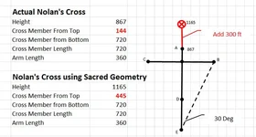
Previously i asked google AI to create a 867ft cross (i.e., the height of Nolans cross) using sacred geometry. The results for the crossmember were substantially off and the angle from cone E to cone B (dashed line) no where near 30 deg so i concluded Nolans cross was not sacred geometry.

After my earlier post shown above, i thought maybe I asked the wrong question and tried again.

I asked...create a cross using the golden ratio where the cross member is 720ft long (i.e., the length of the crossmember of Nolans cross).

The results almost matched every nolan cross dimension, including the 30 deg angle from cone E to cone B, with one exception... the distance from the center point to cone A changed from 144 to 445.

So my theory is a person knowledgeable in sacred geometry would recognize that 144ft is too short and would recalculate the distance to 445ft and dig 300ft further.
 

Attachments

  • Nolan's Cross.webp
    Nolan's Cross.webp
    34.6 KB · Views: 43
This morning i realized the purpose of cone D which is 293ft from cone E but has nothing to do with sacred geometry. 293ft is the number of feet you add to the 144ft at the top of nolans cross or a total or 437ft.

Conclusion: the sacred geometry in nolans cross is disguised or hidden until someone in the "know" adds 293ft to cone A to complete the sacred geometry which identifies where to dig.
 
Although I’ve explained this in detail a number of times on the forum, I appreciate that there may be newcomers here and the following might complement and perhaps reinforce the focus on the swamp seen on The Curse of Oak Island.

The suggestion is predicated on the suspicion that there may have been an overall geometry applied to the island heavily incorporating the ancient roadway, and, specifically, that a survey of the island would have been undertaken which resulted in survey markers being positioned and then left in situ, some of which have been, and are being, found. However, it could have been that some of these ground markers were also pointers, that is, clues as to the nature of the layout and thus how to reproduce it. The Geometric Swamp emerges from investigating this possibility.

View attachment 2253515

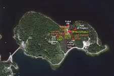
The geometry above has been superimposed on an interactive map from History's 'reality' show The Curse of Oak Island in order to illustrate its fit. I assume they won’t object! MP is the Money Pit, WR and ER are the rocks and WT and MT are the triangles, all geometrically positioned. E is the Eye of the Swamp and X marks the spot!

It's impossible to determine whether or not the many wooden stakes removed from the swamp might align with the suggested figure, since no information is ever forthcoming from the island and some of the information provided is clearly outright wrong and therefore misleading, doubtless intentionally.

The Roadway with its continuation is drawn above as 10 sections of 25 rods thus being 1375 yards long (1257m), just short of three-quarters of a mile. It bears at azimuth 107 degrees (17 degrees south of due east). As observed in a recent thread concerning La Formule, the centre of the Geometric Swamp is some 374 feet from both the Head Stone and Cone D of Nolan’s Cross.

Should tunnels have been cut on the island then it would follow that magnetic compasses were employed in order to navigate underground. However, the bearing of the magnetic compass varies from place to place and over time, and only ocasionally points true to the poles. The angle of difference is frequently referred to as magnetic declination, though I prefer the term magnetic variation.

It would follow that were there tunnels on Oak Island then they would likely betray the angle of magnetic variation operating at the time. However, it's quite possible that a clue was left on the island to indicate what this was. The suggestion is that this was the function of the Welling Triangle, the angle indicated being the arc that is twice the tangent of tilt, or 13 degrees west of north.

View attachment 2253517

Should this be correct, then it was perhaps desirable that this angle needed to be known by someone other than the originator. For what purpose? The location of the Money Pit was made obvious to everybody and they're still digging there (:dontknow:). So, why would it be necessary to provide any other information? Since such information seems to have been intentionally left, I suggest that the focus of the island's geometry is definitely not the Money Pit, and there's a lot pointing to this.

Details are scattered across my previous posts, while a full explanation in the form of an armchair treasure hunt can be found in my book The Oak Island Concealment: Seeing Beyond the Money Pit.Trusted Win Bet casino

The part about using magnetic variation as a built-in reference is actually quite compelling. If they really wanted something recoverable later, leaving a clue like that would make more sense than relying purely on visible markers that could be disturbed over time.
 
More "could it be" and "what if's" from gjb in an attempt to advertise his non-selling book.

His diagrams could be overlaid over any piece of land with the same result.
 
I'm with you. Should someone have a good idea of what was done on the island then they could follow the clues, provided they know about the clues, have access to them, and recognise them and accept them for what they are! This, I feel, may well be the reason the mystery is not being solved. It's being approached with a 21st century mindset not an 18th century one.
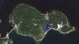
I like the way you guys think. Therefore, may I suggest that the megalith found in the swamp is the 13th megalith of the OI puzzle. That it represents the Eye of Taurus which was the 13th brightest star. That the Mercy Stone also represents 13. A signature or handshake from the depositors. Then the Eye of Taurus appears to chase God at 60 degress (as the solar system is at 60.01 degrees to the galaxy known as the heavens to the medieval depositors. Therefore, the swamp is the start point to recover the Vault. In Nolan's Cross as measured by Fred and Verified by the Stone Triangles internal code . It points 60 degrees and the stone moves at 60 degrees. The distance is 145' at 060T from the only stone in the water, to a location to break ground and execute the next set of intructions. This is conjecture to say that there is an equilateral triangle at 435' surrounding the Eye of Taurus because if you multiply 145 the first distance by 3 you get 435 and this is a way of hiding the number. The triangle has three 60 degree angles around a moving 60 degree star. Oh God the PLEIADES represents God. So the path of God is 60as is the path of the FOLLOWER is what ALDEBARAN means. I have found the 4 features to form a Geospatial Subterranean Offset Vault Astroarcheological Cipher of amazing detal. G2G but at break ground the anhle and the direction of the ramp with the depth makes this statement in code, Christ, Fathers Possessions, Buried in a Crevasse in the Earth
 

Attachments

  • Four Features Equilateral Water Data.webp
    Four Features Equilateral Water Data.webp
    43 KB · Views: 27
I thought about this some more and realized this could be true.

Previously i asked google AI to create a 867ft cross (i.e., the height of Nolans cross) using sacred geometry. The results for the crossmember were substantially off and the angle from cone E to cone B (dashed line) no where near 30 deg so i concluded Nolans cross was not sacred geometry.

After my earlier post shown above, i thought maybe I asked the wrong question and tried again.

I asked...create a cross using the golden ratio where the cross member is 720ft long (i.e., the length of the crossmember of Nolans cross).

The results almost matched every nolan cross dimension, including the 30 deg angle from cone E to cone B, with one exception... the distance from the center point to cone A changed from 144 to 445.

So my theory is a person knowledgeable in sacred geometry would recognize that 144ft is too short and would recalculate the distance to 445ft and dig 300ft further.
This is Nolan's Cross Data. It contains 6 Layers. The Axis Cipher produces a Blueprint of the underground construction when applied to Dr. Taylors Taurus Chart. The Next layer moves the top portion to the swamp stone 145' at 60. Then the Crossbar tells to build a ramp at X . The angle, direction and terminus or depth tell that Christs fathers possessions are buried in the Earth. The below Crossbar segments provide triangulation with the 6 internal angles provide by the Adler's Pyramid Cipher (My other discovery) Then the math gets modified to 10 % to reach the second chamber. In the 6th Layer these angles and distances and directions tell a story in CODE (not Gematria) much of which is found here although some definitions from Kaballah are used https://biblenumbersforlife.com/luke/

Oak Islands the Geospatial Subterranean Offset Vault Astroarcheological Cipher - Star Chart & Keys Cipher
 

Attachments

  • Four Features Nolans Cross Full Data.webp
    Four Features Nolans Cross Full Data.webp
    115.9 KB · Views: 30

Users who are viewing this thread

Latest Discussions

Back
Top Bottom