What's new

Buried Gold in the Iditarod district!

geowizard

Supporting Vendor
🛒 Supporting Vendor
Joined
Apr 9, 2007
Messages
571
Reaction score
513
Golden Thread
0
Primary Interest:
All Treasure Hunting
Hi TreasureNet Treasure Hunters!

I have leads on buried treasure in the Iditarod mining district in Alaska. It was my distinct pleasure to have the opportunity to acquire a mining property at Ophir Creek on the Iditarod Trail. That was in 2010. Coincidentally, I left Ophir for the season in September as an Alaskan geophysical survey crew was arriving! They surveyed the length and breadth of the Iditarod Mining District.

We have an opportunity to discuss the results right here on this thread. I will share some of my many discoveries from that survey with readers! Please chime in with questions and comments.

- Geowizard
 
Last edited:
In 2010, I began placer gold mining at Ophir, Alaska.

I arrived on an air charter from McGrath. It was quiet, almost silent except for the low, ever present, droning sound of mosquitoes. I watched, standing by the runway with my luggage as the airplane flew out of view and disappeared in the distance. I was alone. I was an alone remote prospector about to get his initiation into the world of remote prospecting! I had been in correspondence by email with the owner of the mining claims. We can call him "Mr. R.". I could see a pickup coming toward me from the other end of the runway. As it pulled up and stopped, a lady introduced herself and asked if I needed a ride to Mr. R.'s cabin. She informed me that he was gone to Takotna for supplies and would return in a few hours. After getting dropped off at the cabin, I unpacked and setup my tent camp on the lawn. After the return of Mr. R., I learned more about him and his exploits mining gold at Ophir. :thumbsup:

- Geowizard
 
The 2010 DIGHEM geophysical survey data was released in 2012;

Because I was actively mining in the district, I began the process of interpretation of the Geophysical survey! I wanted to learn more about what the survey data might reveal about where gold deposits were.

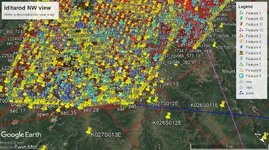
After years of interpretation, I developed a map of geophysical anomalies.

The anomalies were instantiated on Google Earth Pro.

See the attachment for a view of my interpretation of the eastern portion of the survey:

iditarod google earth view.webp

- Geowizard
 
The Ophir/Iditarod survey has a project Report;

Credit for images is given to Alaska DGGS. We are all indebted to their ongoing and tireless work!

The survey was conducted over an area shown on the attached maps.
These maps show the geophysical responses! :thumbsup:

- Geowizard
 

Attachments

Last edited:
The least likely place to find Gold in the Iditarod Mining District is on the third map;

The most Gold mined in the district was one and one-half million ounces of Gold at Flat-Discovery on the third map! I have thoroughly investigated the DIGHEM survey data over the district. The origin of the 1,500,000 ounces of Gold has never been discovered until now. I interviewed with the present claimant in a video conference call. They informed they know more than I do and debated the source of the data. In the end, I didn't reveal the location. Incidentally, they use reports and maps with DIGHEM data as seen on their website. :occasion14:

Fun stuff!

- Geowizard
 

Users who are viewing this thread

Back
Top Bottom