Cache hunting pictures/drawings/signs/markers/soil layers

Margaha, really interesting dig. i would'nt think that the **** did all that digging just for fun.
 

It was just a small island 10claw... it is really possible for them to dug the entire island. They may have thousands of POWs to do it for them.
 

Margaha,
Anugon jud kaayo! The man who had in his possession a significant number of japanese treasure maps of Bohol died of terminal liver cancer more than 20 years ago. He burned them all saying "walay makakupot ug makapahimulos niini!" (Nobody will get hold and benefit from these (maps)!). How did I know?---he was my wife's uncle-- a decorated World War 2 and Korean War veteran and a former top intelligence officer with rank of general during the Marcos dictatorship years.

Tabu

That's quite a story there Tabu... The guy who lured me to these diggings has the maps of minor sites in the entire Philippines if not all. He already recovered some of them but I wonder why he never stopped. My island was 1 site in his map but he never ever told me until I told him that I hired somebody else to scan the area. He said that these maps were given by ****.
 

Are you from Bohol Tabu?
 

Hi Margaha,

I'm not from the beautiful island paradise of Bohol. The late gentleman that I spoke of was a true blue paisano of Dagohoy, the warrior hero of the island. Seems from my hazy recollection of what he mentioned offhand a long time ago, the stashes were inland as well as in the surrounding coastal waters. Best to ask the Japanese who bankrolled the construction of the modern circumferential highway around the island (simultaneous with " archaeological" recovery expeditions--??!--). Unsolicited advice: be always aware that the wartime Japanese military were experts par excellence in creating a whole system of false or misleading signs that were incredibly believable to unsuspecting treasure hunters. I'm confident you won't be misled as you possess the right perspective and oveview. Good hunting!

Tabu
 

Excellent information Tabu... I know of the fact that the Japanese actually made that strategy to recover their loots.
 

Margaha,

I have the feeling you are one of the select few who will solve the mystery of where the Yamashita treasure trove is hidden in Bohol--- or what remains of it. Again, good luck!

Tabu
 

I don't know... It was by mere coincidence and luck that I bought that Island in very good payment terms. I already invested more than a million pesos to develop that area but I failed to harvest prawns in that fishpond for two consecutive runs. That's one reason why I got into digging the island. If not for those failures, I wouldn't dare to move a dirt on that small island because it is really beautiful.
 

Last edited:
Margaha,

Everything has reason fo being. Nobody but no nobody gets to be so lucky as to own an island as you do, prawns or no prawns! The Tiger of Malaya would surely be rolling in his grave seeing you enjoying a plateful of Tiger Prawn tempura under shade of a coconut tree in your treasure of an island in Bohol, Philippines..

Tabu
 

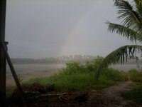
2012-03-23 17.04.38.jpg
If a rainbow is a sign, then I am the luckiest guy on the planet. I was at the end of that rainbow it was thick, so new yet so far. As they say, at the end of the rainbow there is a pot of gold. Maybe it is also a coincidence that rainbow where its colors stood out is a suspected site also.
 

Margaha,

In your rainbow picture there is a coastal landmass across the sea. If your island or islet is part of or within a cluster of islands which is not unusual in the Central Visayan province of Bohol, perhaps the triangulation points of the treasure burial spot are easily identifiable landmarks in the neighboring islands surrounding it. Pack your picnic lunch. But don't forget to bring along a binocular, a NAMRIA topo map and a Coast Guard nautical chart of the area. And of course, a surveyor's compass or better still a theodolite. Or you can scan the spot at the end of the rainbow with a 2-box..

Tabu
 

You seem very familiar with this hobby tabu... got any stories to share about YamTH? I can sense you have already recovered something. am I right?
 

Margaha,

I'm not too sure if I can run away fast enough--- stirring a hornet's nest with palm fronds at the end of a long bamboo pole...

Tabu
 

Tabu, I can tell by the way you choose your words that you got something already. hehehehehe

But anyway, I have a live pointer which is now around 90 yo. He said that during the war he saw a big hole in one of the island in the drawing that I have shown. When he came back to the place, it was already covered.

Actually, the back portion of my Island was also an islet. if we plot it in triangle, my island is the center. To think that previously its shape was a circle.
 

Tabu,

If I may ask, what gadget could be used if I will be searching for treasures under water? Let us Say in a river which is about 10-20ft at low tide.

I would appreciate your advice..

margaha
 

Margaha,

I'm not too sure. You have to seek the help of those with expertise in marine and underwater archaeology and salvage work. Perhaps a DYI or low budget preliminary recon or bottom profiling might work. Enlist the assistance of local divers or spear fishermen who are familiar with the underwater "wrinkles, warts and all" of the place. If the limestone bed of the island is coarse and gravelly, it's possible that a number of treasure boxes encased in concrete cement-limestone admixture and in easily transportable configuration could have been been lowered into the riverbed or seabed in proximity of the beach for convenient pinpointing using landmarks in adjoining islets for triangulation. I wouldn't be too suprised if the hole or pit seen by the sexagenarian WW II survivor was just the remains of the quarrying activities of the Japanese busy with hiding their loot. Personally, I wouldn't dig a deep hole in a limestone island--- too much trouble with the saltwater intrusion while the work is in progress (and afterwards) and it's too easy to find.

An underwater PI unit will come in handy. Do it for fun (you're not going to bail out Greece or save the plummeting euro!). Play safe. Zero accident. No casualties. And inform me if my opinionated views are way off the mark.


Who says a newbie golfer can't make a hole-in-one the first time??

Tabu
 

I will make my own PI detector if that is the case. I'm serious about this. My workers where previous fishermen in the place. They said that a big box always entangles their nets at the deepest portion of the river near my fishpond in front of a small harbor. They don't know if it is still there because a yacht was seen for more than a month and nobody knows if they got it.

The place is very interesting knowing that it is very deep and almost a kilometer away from the ocean. There was a local fisherman who builds a tower "sanggab" who recovered a bronze colored spoon from a a round boulder near 1 of his post. He thought that it was just a bronze, he sold it in a local junkshop for only 1,500 pesos.
Then the **** came to the spot with a boat and left.
 

Top Member Reactions

Users who are viewing this thread

Back
Top