What's new

DIGHEM

geowizard

Supporting Vendor
🛒 Supporting Vendor
Joined
Apr 9, 2007
Messages
503
Reaction score
452
Golden Thread
0
Primary Interest:
All Treasure Hunting
Imagine a metal detector that measures up to 400 feet into the earth!

Digital Helicopter Borne Electromagnetic - DIGHEM.

This is the real deal! Mounted on a an A-Star 350B2 helicopter running survey lines at 90 mph (130 feet per second).

dighem system.webp


It has a footprint 60 feet across!

The data is available to the public. Download it at no cost!

A viewer is available from GeoSoft called Oasis Montaj viewer. It's free!


OM-screen-laptop.webp


Surveys have been done in all of the major mining districts in Alaska!

I have spent 12 years doing interpretation of DIGHEM data.

Stick around! There's more! :)

- Geowizard
 
Last edited:
Not offered at KellyCo or Big Boys Toys yet....
 
Imagine digging a 400 foot hole.


And what have you recovered from your research?
Recovered vs inferred;

There is an important distinction to be made. :)

1. You are standing somewhere in GOLD country in wide-eyed amazement as your detector responds with the loudest most distinctive response to a NUGGET you have ever heard...

What is inferred? Do you dig it?

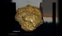
2. You have spent a several thousand hours viewing data from a mining district in Alaska. You are viewing data from within 5 miles of the location of the discovery of the 294.1 troy ounce Alaska Centennial Nugget...

centennial nugget.webp

You discover the highest grade conductor by a factor of 100 in the 3000 miles of survey lines in the mining district. The signature has a phase angle of 5 degrees. Note: Less than 10 degrees is defined as GOLD. The conductor is 200 feet long. The deposit within a designated cutoff grade is 2000 feet long.

What is inferred? Do you dig it?

Stick around. There's more! :)

- Geowizard
 
Imagine a metal detector that measures up to 400 feet into the earth!

Digital Helicopter Borne Electromagnetic - DIGHEM.

This is the real deal! Mounted on a an A-Star 350B2 helicopter running survey lines at 90 mph (130 feet per second).

It has a footprint 60 feet across!

The data is available to the public. Download it at no cost!

A viewer is available from GeoSoft called Oasis Montaj viewer. It's free!

Surveys have been done in all of the major mining districts in Alaska!

I have spent 12 years doing interpretation of DIGHEM data.

Stick around! There's more! :)

- Geowizard
Here we are mostly ravenous about the Art of metal detecting in our nearby communities and are more impressed by the history of primitive artifacts we find and interpreting what they were used for in Old times than what their Gold content may be....
We are like down to earth Happy-go-lucky scavengers of what's within 25 mile radius. Alaska sounds cold and too vast ( too expensive to roam through on ATV or whatever) and already Taken to be intriguing to humble scavengers and Artists that many of us here are.
 
Last edited:
I would dig it.

I sold my Gold Mine in the Iditarod Mining District for a six figure sum in 2021.

I invested that sum over five years in staking, claiming, buying tools, materials, building supplies, four wheelers, an 8x8 Argo and moving all of that to the remote, never before discovered project area.

From the survey data, the top of the deposit is 40 feet below the surface. The survey data shows a portion of the deposit having "negative depth". Negative depth says there is an outcropping (above the surface) of the deposit. The project area is permitted and is 8 miles through "bush" with no access trail. I flew in there for staking by helicopter. Round trip ticket for the charter was $5,000. I can safely say, "mankind has never walked through this area." It was buried and remained undiscovered with one possible exception.

Stick around and find out who it may have been! :)

- Geowizard
 
The Alaska Centennial Nugget:

The Alaska Centennial Nugget was discovered at a well published location. Viewing the DIGHEM survey data, the location is "non mineral" in character. The location of discovery can be excluded as the source of the Nugget. Every adventure seeks metal detector enthusiast with financial means has swung detectors all over the immediate area without success. The location is NOT in a wash, creek bed or other erosional system. It is on a gradually sloping hillside.

Theory 1: The Nugget was discovered elsewhere and was being hand carried to a nearby mining camp. Enroute, the prospector became tired of carrying a 20 pound nugget through the wild bush of Alaska. He or she sat down to rest, possibly falling asleep. It is known bear country. It's not much of a stretch of the imagination to imagine a bear on the hunt for food and tracking or following the scent of a potential food source. I will leave the rest of that imaginary theory to the reader. argh...

Theory 2: Glaciers have scoured much of the area in Alaska. Rocks known as erratics were moved/bulldozed by Glacial Ice many miles. Was the nugget moved by Glacial ice?

Theory 3: Ambush. The hypothetical prospector may have shared information about his or her discovery. The news preceded the intrepid prospector. An individual or individuals tracked or otherwise caught up with the prospector and as the prospector became aware of an impending ambush. buried the nugget.

The source of the nugget was never discovered until now.

I have had a discussion with the person that discovered the nugget. He offered more details.

Don't go away, there's more! :)

- Geowizard
 
Here we are mostly ravenous about the Art of metal detecting in our nearby communities and are more impressed by the history of primitive artifacts we find and interpreting what they were used for in Old times than what their Gold content may be....
We are like down to earth Happy-go-lucky scavengers of what's within 25 mile radius. Alaska sounds cold and too vast ( too expensive to roam through on ATV or whatever) and already Taken to be intriguing to humble scavengers and Artists that many of us here are.
Welcome to TreasureNet!

TreasureNet is used for different things by different people. There are those that may think finding coins in their community park is exciting and interesting and it is. Other treasure hunters are seeking new methods of prospecting for gold and other precious metals using data from bigger and better tools that measure deeper into the earth.

Geophysical tools range from low cost metal detectors to commercial survey tools that provide valuable data that is free and is published on the internet. There are members of this forum and non-member readers from all over the World. Many treasure hunters are well funded experts that travel world-wide in their search for buried treasure in many forms including archaeological artifacts. :)

So, stick around! There's more!

- Geowizard
 
Last edited:
Everything I Dowse is inferred.
I signal the presence of, but not the quality of..
 
View attachment 2243906

You discover the highest grade conductor by a factor of 100 in the 3000 miles of survey lines in the mining district. The signature has a phase angle of 5 degrees. Note: Less than 10 degrees is defined as GOLD. The conductor is 200 feet long. The deposit within a designated cutoff grade is 2000 feet long.

What is inferred? Do you dig it?

Stick around. There's more! :)

- Geowizard
If their signaling conductivity, might the target possibly be, Silver, or Nickel, or Copper?
I look forward to more large nugget info.
 
Last edited:
Welcome to TreasureNet!

TreasureNet is used for different things by different people. There are those that may finding coins in their community park is exciting and interesting and it is. Other treasure hunters are seeking new, methods of prospecting for gold and other precious metals using data from bigger and better tools that measure deeper into the earth.

Geophysical tools range from low cost metal detectors to commercial survey tools that provide valuable data that is free and published on the internet. There are members of this forum and non-member readers from all over the World. Many treasure hunters are well funded experts that travel world-wide in their search for buried treasure in many forms including archaeological artifacts. :)

- Geowizard
Again, am no expert. But if you ( from the drilling perspective on your side ) want to kind of neglect some deposits like Molybdenum and Vanadium because of their hardness, as well as Titanium because of its abundance and Zirconium too, I would seek gold deposits where Manganese or Bismuth deposits are. But I would first find way to register the Manganese Signals despite its low electroconductivity but make it appear as equal strenght to Gold.or almost, and will then Select areas where MN signal is medium strenght ( as juxtaposed to whatever well conductive elements are in same landmases ). Like 60 % strenght of Au signal.
Same for More Narrowerly positioned deposits of Silver. I would look for Au 30 or 40 % or more stronger than the Silver signal that corresponds to visible Ag deposits. But Ag not As Gathered from a broad area. Rather maybe from deeper area.
 
If their signaling conductivity, might the target possibly be, Silver, or Nickel, or Copper?
I look forward to more large nugget info.
A short Tutorial:

There are TWO signals that contain the secret sauce for a simple calculation of "Phase angle". Every discriminating metal detector uses these two signals. Think of the signal returning from the earth. It's called the response. The response is measured by the receiver coil. When a metal or conductive mineral is in the field of detection, the response is measured at the receiver coil as an "amplitude" and a "phase" change! :occasion14:

Think of a right triangle. A right triangle has three sides called the base, opposite and hypotenuse.

The length of the base is one component of the response. The length of the opposite side is the other component. The "angle" of the hypotenuse relative to the base is the angle!

Whites Electronics got a patent on this concept. This is the KEY to "discrimination" in discriminating metal detectors!

The "phase" angle is a calculation so get out your handy dandy scientific calculator. :)

There are keys used to solve the lengths and angles of the sides of a triangle. For those that did not take Trigonometry in high school, please hang in there with me on this!

One of the keys says "ATN". That's the key to get phase angle. There is an "INV" key. The function you need is INV ATN also known as ARCTANGENT. You just graduated to Master of Trigonometry!

The easy part is one of the functions of a four function calculator called DIVIDE. :)

Reading the DATA now, there are columns of DATA. Each column has a label for a signal. They may be abbreviated and the result after calculation is PHASE ANGLE.

From the Patent info:

A Phase angle of 10 degrees or less is GOLD or SILVER or a combination of the two.

A Phase angle of 30 Degrees is COPPER.

A Phase angle of 90 degrees is IRON.

In-between angles? More research needs to be done! All of the metals and related minerals have a Phase Angle!

COPPER-SILVER-GOLD is in the range from 10 degrees (GOLD SILVER) and 30 degrees (COPPER).

IRON SUPPRESSION:

IRON moves the angle toward 90 degrees. It makes GOLD and SILVER look like IRON in a mix of metals and minerals. DIG it and find out! :)

Fun Stuff! :)

- Geowizard
 
Last edited:

BONUS info:

The length of the inphase (base) side and the length of the opposite (Quadrature) side control the length of the hypotenuse of the right triangle. The length of the hypotenuse is the INTENSITY of the response.

Are we having FUN yet? :)

- Geowizard
 
Everything I Dowse is inferred.
I signal the presence of, but not the quality of..
If you say so. With all due respect, peer review and debunking by Randi and others show otherwise.

I'm still waiting for more support for the method. :)

- Geowizrd
 
Last edited:

A short Tutorial:

There are TWO signals that contain the secret sauce for a simple calculation of "Phase angle". Every discriminating metal detector uses these two signals. Think of the signal returning from the earth. It's called the response. The response is measured by the receiver coil. When a metal or conductive mineral is in the field of detection, the response is measured at the receiver coil as an "amplitude" and a "phase" change! :occasion14:

Think of a right triangle. A right triangle has three sides called the base, opposite and hypotenuse.

The length of the base is the "Inphase" component of the response. The length of the opposite side is the "quadrature" component. The "angle" of the hypotenuse relative to the base (inphase) is the "Phase" angle!

Whites Electronics obtained a US Patent on this concept. Anyone familiar with patent searches can "read all about it"! This is the KEY to "discrimination" in discriminating TR metal detectors!

The "phase" angle is a calculation so get out your handy dandy scientific calculator. :)

There are keys used to solve the lengths and angles of the sides of a triangle. For those that did not take Trigonometry in high school, please hang in there with me on this!

One of the keys says "ATN". That's the key to get phase angle. There is an "INV" key. The function you need is INV ATN also known as ARCTANGENT. You just graduated to Master of Trigonometry!

The easy part is one of the functions of a four function calculator called DIVIDE. :)

Reading the DATA now, there are columns of DATA. Each column has a label for signals like Inphase and Quadrature. They may be abbreviated like CPI and CPQ. Divide CPQ by CPI and do the INV ATN. The result is PHASE ANGLE.

From the Whites Electronics US Patent info:

A Phase angle of 10 degrees or less is GOLD or SILVER or a combination of the two.

A Phase angle of 30 Degrees is COPPER.

A Phase angle of 90 degrees is IRON.

In-between angles? More research needs to be done! All of the metals and related minerals have a Phase Angle!

COPPER-SILVER-GOLD is in the range from 10 degrees (GOLD SILVER) and 30 degrees (COPPER).

IRON SUPPRESSION:

IRON moves the angle toward 90 degrees. It makes GOLD and SILVER look like IRON in a mix of metals and minerals. DIG it and find out! :)

Fun Stuff! :)

- Geowizard
A Phase angle of 10 degrees or less is GOLD or SILVER or a combination of the two.

A Phase angle of 30 Degrees is COPPER.

A Phase angle of 90 degrees is IRON.

I don't know about electronics, almost zero.
But I think what you are describing by 10 degrees or less, the helicopter detectors at this ( mechanical ) angle are registering the most spontaneous/ streamlining Gold / silver deposits. Rather their shallower surfacing points. They are pretty precisely pinpointed. But I don't know ( even with 18 meters broad collection width of land capacity) if ALWAYS these " eruption" areas are being fed by the most concentrated Gold deposits underneath. As compared to how concentrated or large other SIIDEWAYS gold deposits may be but not able to Reach surface as convincingly.
Plus, the feeding larger deposits may be connected mainly through Diagonally emerging veins or enriched streaks.
And below 300 or 400 feet you said it's murky.
So every several Meters sideways of not Preferentially 10 degree or less registered landmasses IMMEDIATELY arrived at with initual scanning, may cost you weeks if not months, even if you have equipment.

Of course if you want total 100 % advance planning of optimal outcomes for given efforts...
And thousands of hours of data already sunk in/ analyzed, so I guess at this point you are only interested in extreme looking anomaly spots....
In potentially most difficult and challenging terrain.

I still believe the most economically lucrative Au deposits are where Silver deposits are. Unless the Platinum group elements share somewhat common signature in terms of degrees and what not WHEN and where they are nearby gold accessible deposits.

Does Handheld GPS work in the crevices of those forests with at least 50 m sideways precision in most weather conditions? Or at least 150 meters ? Just a question .


And forgive me for this paranoia but when Uncle Sam decides they need all newly discovered rare metals from Alaska set aside for weaponry?? We then better have enough fuel and food and strenght left to get out ! :))
 
Last edited:
Imagine digging 400 foot holes, 13 feet apart, 10 times per second and getting samples. :occasion14:

- Geowizard
Oh... and getting an instantaneous assay of each sample!

All at no cost. :)

- Geowizard
 
If their signaling conductivity, might the target possibly be, Silver, or Nickel, or Copper?
I look forward to more large nugget info.
dowser, It can be Nickel but more spilled over broader area Nickel deposits. Plus it might be situation based.
But I have told you maybe before, Nickel just serves to reinforce the gold streak/ source presence. But depending on what and how bulky other Gray-color compatible elements are in contact with the Au- accompanying Nickel deposits, the Gold signal may be very slightly weaker. I think so at least.
But gold concentrated mass is not able to communicate to another concentrated gold pure mass, unless they are connected by soil and minerals containing " totally different " elements.
Unless are really close to each other....I think
 

Users who are viewing this thread

Back
Top Bottom